High-Altitude Landforms of Asia
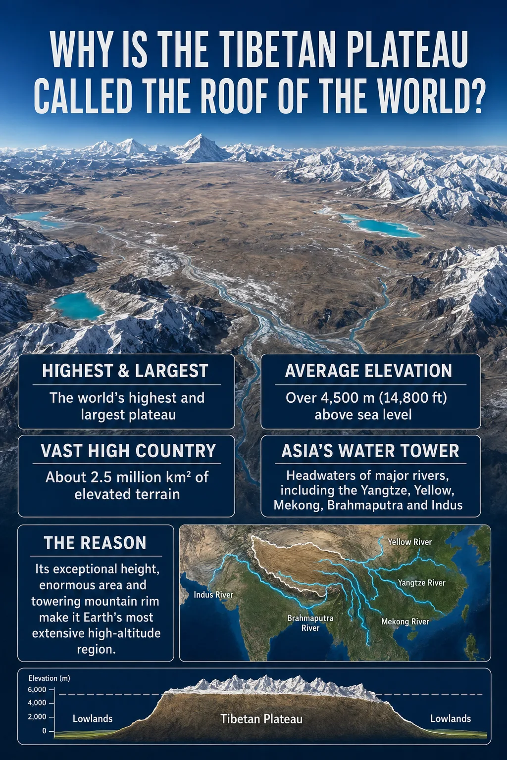
The Tibetan Plateau is called the Roof of the World because it combines an average elevation above 4,500 meters with an immense, broadly connected upland surface. No other plateau matches both its height and geographic scale.
The nickname refers to the height of the whole landform, not just to the Himalayan summits along its southern edge. Much of the plateau floor stands at elevations that would count as high mountains elsewhere. Yet it extends roughly 2,500 kilometers from west to east and as much as 1,000 kilometers from north to south.
| Geographic Measure | Tibetan Plateau | Why It Matters |
|---|---|---|
| Landform type | High tectonic plateau with internal ranges and basins | The nickname describes a raised region, not one mountain |
| Approximate area | About 2.5 million km² | It is generally identified as the world’s largest high plateau |
| Average elevation | More than 4,500 m (14,760 ft) | Its average surface is higher than many famous mountain summits |
| Approximate extent | About 2,500 km east to west and up to 1,000 km north to south | The high terrain continues across a large part of interior Asia |
| Main mountain margins | Himalayas, Karakoram, Kunlun, Qilian, and Hengduan systems | These ranges form high rims and sharp transitions to lower terrain |
| Common alternate name | Qinghai–Tibet Plateau | Different geographic traditions use slightly different boundaries |
Measurement Note
Area and elevation figures vary because researchers do not always use the same boundary. Some definitions include adjoining mountain belts and marginal basins, while others measure only the main plateau surface. Values near 2.5 million km² and an average elevation above 4,500 meters are widely used geographic approximations.
Map Note
The map provides general orientation. A place label or shaded map area should not be treated as the plateau’s exact scientific boundary, especially along the Himalayas, Karakoram, Qilian Mountains, and deeply cut eastern margin.
What “Roof of the World” Actually Means
A roof is a broad surface raised above the space around it. The metaphor works because the Tibetan Plateau forms a vast, elevated base from which mountain ranges, river valleys, basins, and individual peaks rise.
The word world expresses its global rank. The plateau is not the highest individual place on Earth, but it is the highest extensive plateau. Other highlands may contain tall peaks or smaller high basins, yet they do not combine the Tibetan Plateau’s average elevation with a comparable area.
- High average surface: Much of the land already stands between roughly 4,000 and 5,000 meters before nearby peaks are measured.
- Large continuous footprint: The elevated terrain covers a region comparable in area to a large country.
- High mountain rim: Major ranges surround or cross the plateau, making the region appear even more elevated.
- Sharp outer margins: Terrain falls toward the Tarim Basin, Hexi Corridor, Sichuan Basin, and South Asian lowlands.
Elevation Note
The nickname is based on regional elevation, not the height of Mount Everest. Everest rises to 8,848.86 meters on the Himalayan rim, while the plateau’s distinction comes from maintaining very high elevations across millions of square kilometers.
Why a Plateau Can Be Both High and Mountainous
A plateau does not need to be completely flat. In physical geography, it is an extensive area that stands high relative to surrounding land. Its surface can contain hills, mountain chains, valleys, lakes, and enclosed basins.
The Tibetan Plateau is especially rugged around its margins. The Himalayas rise along the south, the Kunlun system borders the north, and the Karakoram forms part of the western mountain setting. In the east and southeast, the terrain is cut into long mountain ridges and deep, closely spaced river valleys.
The interior often has broader relief. High plains and lake basins lie between mountain ranges such as the Tanggula, Gangdise, and Nyainqentanglha. These plains may look relatively level when compared with the surrounding peaks, although they remain extremely high above sea level.
Common Mix-Up
The Himalayas and the Tibetan Plateau are connected but not identical. The Himalayas are a mountain system along the plateau’s southern margin. The plateau is the much broader elevated region to the north and includes its own ranges, plains, valleys, and basins.
How Such a Wide Area Rose So High
The plateau developed within a broad zone where the Indian and Eurasian landmasses converged. Their collision began roughly 60 million years ago, although parts of southern and central Tibet had already developed high mountain belts before the broad plateau reached its present form.
Continued convergence shortened and thickened the crust. Faulting, folding, underthrusting, changes in the deeper lithosphere, and the uplift of basins between older mountain belts all contributed. The modern surface therefore did not rise as one rigid slab or during a single event.
Older Terranes and Mountain Belts Form
Before the full India–Asia collision, earlier continental fragments and volcanic arcs had already created varied terrain across southern and central Tibet.
Continental Convergence Compresses the Region
Northward movement of the Indian landmass placed sustained pressure on the southern edge of Eurasia.
The Crust Shortens and Thickens
Rock layers folded, faulted, and stacked while parts of the Indian lithosphere moved beneath the plateau region.
Mountain Belts and Basins Become a High Plateau
Uplift affected separate areas at different times. As intervening basins rose, the landscape developed a more continuous high surface.
Geography Note
The familiar statement that the plateau formed when India collided with Eurasia is broadly correct but incomplete. Geological evidence points to a long, uneven history involving older highlands, delayed basin uplift, crustal deformation, and different uplift mechanisms across the region.
High Mountain Rims Strengthen the Roof Effect
The plateau’s position between major ranges makes the nickname easier to understand on a physical map. Its outer edges resemble a raised platform bordered by mountain walls and steep transitions.
Southern Margin
The Himalayas separate much of the plateau from the lower plains of the Indian subcontinent. This is the most dramatic margin, with extreme local relief between high peaks, river gorges, foothills, and adjoining lowlands.
Northern and Northeastern Margins
The Kunlun, Altyn-Tagh, and Qilian mountain systems mark transitions toward the Tarim Basin, Qaidam Basin, Hexi Corridor, and dry areas farther north. The plateau surface can fall by several thousand meters across relatively short horizontal distances.
Eastern Margin
The eastern plateau does not end along one simple escarpment. It breaks into the Hengduan Mountains and a series of deep north–south valleys. Rivers cut through this terrain before continuing toward the lower regions of eastern and southeastern Asia.
What the Roof-Like Elevation Does to the Landscape
The nickname describes height, but that height also controls the plateau’s climate, vegetation, drainage, and settlement patterns.
Thin Air and Cold Conditions
Air pressure and oxygen availability decrease with elevation. At much of the plateau’s surface, atmospheric pressure is far lower than at sea level. Temperatures are also reduced by altitude, although strong sunlight can warm exposed ground during the day.
Large areas support alpine grassland, cold steppe, sparse shrubland, permafrost, glaciers, and seasonally frozen ground. Conditions are not uniform. The southeast receives more moisture, while much of the western and northern interior is colder and drier.
A High Divide Between Major Drainage Systems
Water flowing away from the plateau enters several of Asia’s major river systems. Snow, glaciers, rainfall, wetlands, springs, and high lakes all contribute to headwater environments, though their relative roles differ from basin to basin.
| River System | Plateau Connection | General Flow Direction |
|---|---|---|
| Indus | Headwaters near the western and southwestern plateau | West and southwest toward the Arabian Sea |
| Yarlung Tsangpo–Brahmaputra | Crosses southern Tibet in a long high valley | East, then south toward the Indian subcontinent |
| Yangtze | Headwaters in the eastern plateau region | Generally east across China |
| Yellow River | Headwaters on the northeastern plateau | East and northeast across northern China |
| Mekong | Begins in the eastern plateau under the name Lancang | South through mainland Southeast Asia |
| Salween | Rises in the plateau and crosses its eastern margin as the Nu River | South toward the Andaman Sea |
Not all water leaves the plateau. A large part of the interior contains endorheic basins, where streams drain into lakes without reaching an ocean. Evaporation removes water from these closed systems, and many interior lakes contain saline or brackish water.
Influence on Atmospheric Circulation
The plateau forms a huge mechanical barrier in the middle troposphere and a broad surface that heats and cools differently from surrounding lowlands. These effects influence regional circulation, moisture transport, and monsoon behavior.
Its role should not be reduced to a claim that the plateau single-handedly creates the Asian monsoons. Land–sea temperature differences, seasonal pressure patterns, oceans, jet streams, and surrounding mountain systems also shape those circulation patterns.
Why the Plateau Does Not Look Like One Flat Roof
Satellite images reveal a broken surface rather than a smooth tableland. Long mountain chains cross the plateau, while faults, rivers, glaciers, and erosion divide it into smaller landscape units.
The western and northern interior contains broad cold plains and numerous closed lake basins. Southern Tibet includes the long Yarlung Tsangpo valley between major mountain belts. The eastern plateau changes into steep ranges separated by the upper Yangtze, Mekong, Salween, and their tributaries.
This variety does not weaken its classification as a plateau. The defining feature is the high regional base level. Mountains rise from an already elevated surface, and rivers must descend thousands of meters before reaching surrounding lowlands.
Is “Roof of the World” an Official Geographic Title?
No. It is an informal nickname rather than a scientific classification or protected geographic title. Researchers use terms such as Tibetan Plateau, Qinghai–Tibet Plateau, or more specific tectonic and physiographic subdivisions.
The expression is also not exclusive to Tibet. It has long been applied to the Pamir Mountains and is sometimes used for the Himalayas, Nepal, or the wider high-mountain interior of Asia. Earlier geographic writing often connected the phrase especially closely with the Pamirs.
Modern use for the Tibetan Plateau rests on a clear physical comparison: it is the world’s largest plateau at such an extreme average elevation. The Pamirs deserve the same nickname in a narrower mountainous sense, while the Tibetan Plateau fits it as an immense elevated land surface.
Landform Note
Roof of the World, Third Pole, and Water Tower of Asia describe different qualities. “Roof” refers mainly to elevation and scale. “Third Pole” refers to the wider region’s snow, glaciers, and frozen ground. “Water tower” refers to its role in storing water and feeding major drainage systems.
Frequently Asked Questions
Why is the Tibetan Plateau called the Roof of the World?
It has an average elevation above 4,500 meters and covers roughly 2.5 million square kilometers. This combination makes it the highest and largest extensive plateau on Earth.
Is the Tibetan Plateau the highest place on Earth?
It is the highest plateau by average regional elevation, but it does not contain the highest elevation at every point. Mount Everest is Earth’s highest summit above sea level and rises along the plateau’s southern Himalayan margin.
Is the Tibetan Plateau flat?
No. It contains high plains, mountain ranges, valleys, glaciers, lakes, and enclosed basins. It is classified as a plateau because the whole region stands high above surrounding lowlands, not because its surface is perfectly level.
Are the Himalayas part of the Tibetan Plateau?
The Himalayas form the plateau’s southern mountain margin. They are closely connected geologically, but the Himalayan range and the broader plateau are different landforms.
How high is the Tibetan Plateau?
Its average elevation is commonly reported as more than 4,500 meters (about 14,760 feet). Individual valleys may be lower, while internal ranges and surrounding peaks rise much higher.
Did the Indian and Eurasian plates create the plateau?
Their convergence drove much of the crustal shortening, thickening, and uplift that produced the modern plateau. However, some mountain belts were already elevated before the full continental collision, and separate parts of the region rose at different times.
Is the Pamir also called the Roof of the World?
Yes. The nickname has a long association with the Pamir Mountains and is also used for the Tibetan Plateau and wider High Mountain Asia. It is an informal geographic expression, so it does not refer exclusively to one place.