INTERACTIVE CONTEXT MAP
Where is Yukon Plateau?
The selected plateau and nearby mapped locations are shown. Open the full world atlas to explore every region.
The Yukon Plateau is a broad northern upland of rolling ridges, dissected tablelands, deep river valleys and isolated mountain blocks across much of interior Yukon. Its name suggests a flat elevated surface, but the real landscape is far more varied: long erosion surfaces are cut by major drainage corridors, broken by structural trenches and altered unevenly by Pleistocene ice.
Dissected upland terrain
Yukon River drainage
The Yukon Plateau Is an Upland System, Not a Flat Table
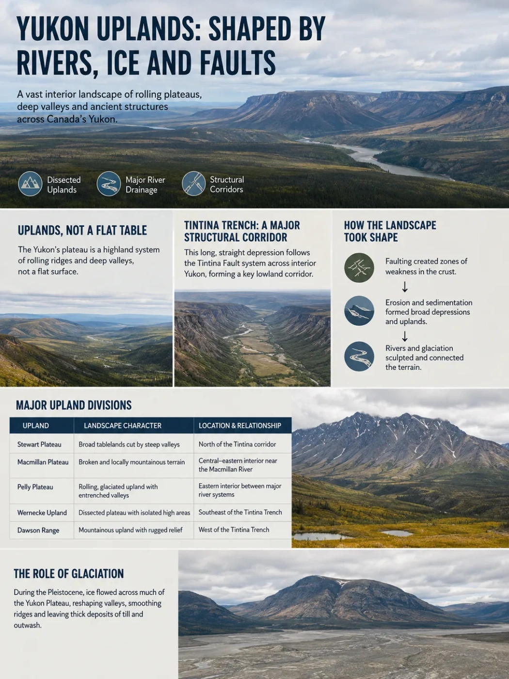
On a regional map, the Yukon Plateau occupies much of the interior between the higher mountain systems of western and eastern Yukon. The terrain commonly consists of rolling or gently rounded uplands separated by broad to deeply incised valleys. In some areas the ridge tops line up at similar heights, giving the landscape the appearance of an older surface that has been cut apart by later erosion.
This is why the word plateau can be misleading when applied to Yukon. There is no single horizontal platform with one clear rim. The plateau is better understood as a large physiographic family of uplands whose original relief has been modified by rivers, faults, weathering and glaciation.
Parts of southern Yukon retain low-relief, broadly accordant uplands. Elsewhere, especially where rivers have cut deeply or resistant rock forms local massifs, the terrain can appear mountainous even though it belongs to the wider plateau landscape.
Why the Name Can Be Confusing
Yukon Plateau is a physiographic name, while modern ecological mapping also uses more specific units such as Yukon Plateau-Central and Yukon Plateau-North. Their boundaries should not be treated as identical to every older physiographic definition of the plateau.
The Tintina Trench Cuts Through the Plateau Landscape
One of the clearest organizing features of interior Yukon is the Tintina Trench, a long, straight northwest–southeast depression developed along the Tintina Fault system. It crosses the plateau country through places including the Ross River area and continues northwest toward central Yukon and the Alaska border.
The trench is much lower than many surrounding uplands and can be several kilometres wide. Rivers occupy portions of this structural corridor, while steep valley sides locally create several hundred metres of relief between the trench floor and adjacent terrain.
Its importance is greater than that of an ordinary river valley. The Tintina Trench separates and connects different sections of the interior uplands, provides a major topographic corridor through the Cordillera and follows a deep geological structure that long predates the modern drainage pattern.
Long-term movement along the Tintina structural system created a zone of weakened and displaced crust.
Erosion and sedimentation helped develop the long trench-like lowland visible across interior Yukon.
Sections of several rivers follow or cross the lower terrain, linking the structural depression with the modern river network.
A Network of Plateaus, Ridges and Lowlands
Older physiographic descriptions divide the wider Yukon Plateau into several named uplands rather than treating it as one uniform block. The arrangement changes noticeably from one part of Yukon to another.
| Area | Landscape Character | Geographic Relationship |
|---|---|---|
| Stewart Plateau | Broad tablelands cut by steep-sided valleys | Interior upland north of the Tintina corridor |
| Macmillan Plateau | Broken and locally mountainous plateau terrain | Extends through the central-eastern interior near the Macmillan River |
| Pelly Plateau | Rolling, glaciated upland dissected by entrenched valleys | Part of the eastern interior plateau country |
| Lewes Plateau | Lower, broad upland and depression terrain | South of the central Pelly Mountain area |
| Nisutlin Plateau | Interior plateau terrain east of Teslin Lake | Part of the southern Yukon uplands |
| Teslin Plateau | Rolling southern upland affected by glaciation | West of Teslin Lake |
| Klondike Plateau | Smooth-topped ridges divided by deep, narrow valleys | Western interior near Dawson and the Alaska border |
These names reveal an important feature of Yukon geography: plateau and mountain terrain interlock. The Pelly Mountains, Dawson Range, Anvil Range and other uplands rise within or beside terrain that may be classified more broadly as plateau country. A local landscape can therefore have steep slopes and mountain-like relief without contradicting its regional physiographic setting.
Rivers Have Cut the Upland Into Separate Blocks
The plateau is tied closely to the Yukon River system. The Yukon, Pelly, Stewart, Macmillan, Nordenskiold, Big Salmon and Little Salmon rivers occupy valleys that divide the uplands into recognizable blocks.
Some valleys are broad and contain terraces, floodplains or wetlands. Others are entrenched below older upland surfaces. Tributary streams have extended this dissection into smaller valleys and gullies, leaving rounded ridges between drainage lines.
This river network explains why the Yukon Plateau often looks less like a continuous plateau from ground level than it does on a regional relief map. The remaining uplands may preserve similar summit levels, but modern drainage has separated them into ridges, hills and isolated high ground.
The Stewart and Pelly Corridors
The Stewart River crosses central Yukon through a broad interior valley before joining the Yukon River. Around the Mayo and Stewart Crossing region, lower valley terrain lies between much higher uplands, producing a strong vertical contrast within the Yukon Plateau-North landscape.
The Pelly River follows another major interior corridor. Together with the Macmillan and Ross river systems, it divides the eastern plateau into highlands and mountain blocks rather than leaving a continuous elevated surface.
Glaciation Did Not Affect Every Part of the Plateau Equally
The modern landforms of the Yukon Plateau cannot be understood from bedrock and rivers alone. During the Pleistocene, large parts of southern and central Yukon were covered or invaded by lobes of the Cordilleran Ice Sheet. Yet the extent and thickness of ice varied greatly.
In parts of southern Yukon, ice covered entire plateau sectors and moved through existing valleys. In central areas near the former limits of the McConnell Glaciation, some high summits and western uplands remained above or beyond the ice. Thin ice was strongly guided by the pre-existing topography.
Ice smoothed some surfaces, widened valleys and left till and other glacial deposits across lower terrain.
Existing valleys channelled glacier movement, so ice flow often followed the structure of the older plateau instead of erasing it.
Some western and higher areas escaped the most recent major ice coverage, preserving older weathered and river-cut landforms.
The contrast can be seen particularly well between smoother glaciated uplands and sections of the Klondike and central plateau country where long-term stream erosion produced dense networks of narrow valleys. Yukon therefore contains neighbouring plateau landscapes with very different surface histories.
The Plateau Surface Predates the Ice Age
Glaciers modified the Yukon Plateau, but they did not create the basic upland. Geological work in southern Yukon has identified extensive erosion surfaces that existed before the major Quaternary glaciations. These older surfaces help explain the repeated pattern of rounded, broadly similar summit elevations.
Long periods of erosion lowered earlier mountain terrain and produced smoother uplands. Later uplift and river incision increased local relief. Valleys cut downward while remnants of the older surface survived above them.
The result is a landscape in which age is expressed vertically: younger rivers occupy the lower valleys, while fragments of older erosional topography remain on the high ground. Glacial erosion then modified this pattern differently from one drainage basin to another.
Its Bedrock Is Much More Varied Than Its Surface Form
The Yukon Plateau is a landform region rather than a single rock unit. Beneath its uplands are sedimentary, volcanic, metamorphic and intrusive rocks formed in very different geological settings.
Parts of the plateau lie on rocks associated with the ancient North American continental margin. Other sections include terranes that were added to western North America during the long tectonic development of the Canadian Cordillera. Granitic intrusions, volcanic sequences and strongly deformed sedimentary and metamorphic rocks occur within the broader plateau country.
This explains why similar-looking rounded uplands can rest on very different bedrock. Regional erosion can produce a shared surface form across multiple geological units, while harder rock bodies may remain as isolated ranges or resistant mountain blocks.
Modern Ecoregions Use a More Detailed Yukon Plateau Classification
Contemporary Canadian ecological classification divides part of the old plateau concept into smaller mapped regions. Within the Northern Boreal Cordillera, Yukon Plateau-Central and Yukon Plateau-North are treated as separate ecoregions.
Yukon Plateau-North includes areas associated with the Stewart River, Stewart Valley, Pelly River, Tintina corridor and uplands around the Anvil Range. Yukon Plateau-Central occupies terrain farther south and includes broad lowlands and uplands around river systems such as the Nordenskiold and parts of the Yukon and Pelly drainage.
The northern ecoregion contains a wide elevation range, from low river valleys only a few hundred metres above sea level to uplands and mountain blocks rising above 2,000 metres. The central ecoregion also spans low valleys and much higher plateau terrain. These ranges reinforce why neither region should be pictured as a level surface.
Map Reading Note
A map labelled Yukon Plateau may show a broader physiographic region than a modern map labelled Yukon Plateau-North or Yukon Plateau-Central. The latter are ecological mapping units with defined ecoregion boundaries, not simply northern and southern halves of every historical Yukon Plateau definition.
Elevation Shapes the Northern Upland Environment
Lower plateau valleys support much of the region’s boreal forest, with white spruce, black spruce and mixed forest occupying suitable sites. Higher slopes pass into more open woodland, shrub communities and alpine vegetation as elevation rises and growing conditions become colder.
Permafrost is also uneven. In the Yukon Plateau-North region it occurs commonly on cooler sites and in lower slope positions, while warmer, well-drained slopes can have very different ground conditions nearby. Aspect, elevation, drainage and surficial deposits therefore create strong local contrasts across what appears on a small-scale map to be one upland region.
The same relief controls wetlands. Broad river valleys and poorly drained depressions can support fens, swamps and shallow-water systems, while steep uplands drain rapidly. This mixture of dry ridges, forested slopes, river flats and wet valley bottoms is one of the defining physical patterns of the interior plateau.
How the Yukon Plateau Fits Into the Canadian Cordillera
The Yukon Plateau occupies an interior position within the northern Canadian Cordillera. Higher mountain belts rise around and through it, while trenches and large river valleys provide lower corridors across the upland.
Its landscape therefore forms a transition between very rugged mountain terrain and the lower plains and basins of northern Canada. The distinction is based less on a sharp edge than on changes in relief, bedrock structure, valley form and the continuity of elevated erosion surfaces.
Seen at regional scale, the plateau is a broad elevated interior. Seen locally, it becomes a complex pattern of rounded highlands, entrenched rivers, structural valleys, glaciated basins and isolated ranges. That difference in scale is central to understanding why the Yukon Plateau is classified as a plateau even where much of the terrain does not look flat.