INTERACTIVE CONTEXT MAP
Where is Labrador Plateau?
The selected plateau and nearby mapped locations are shown. Open the full world atlas to explore every region.
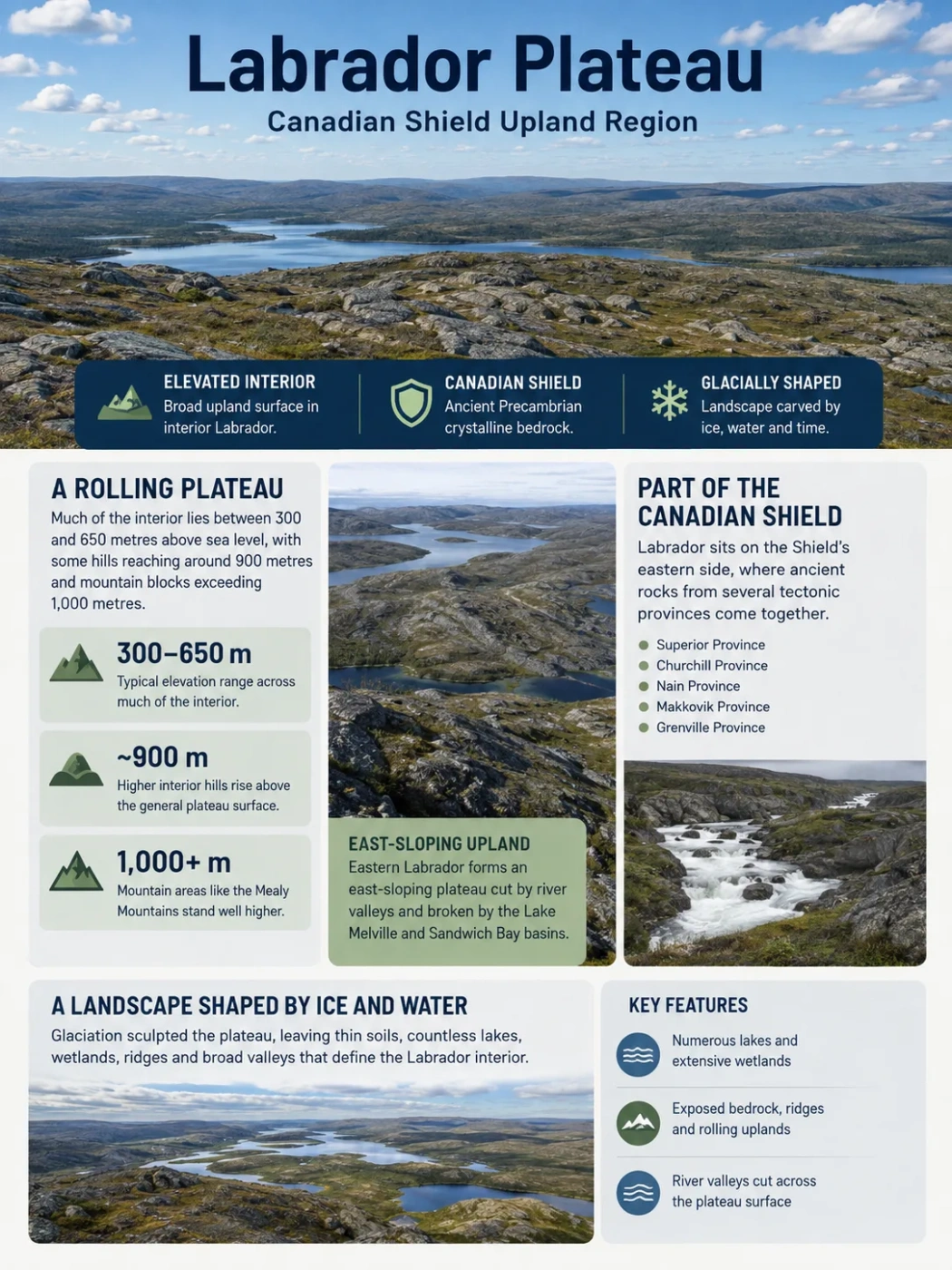
The Labrador Plateau is the broad, elevated interior of Labrador, built on ancient Canadian Shield rocks and heavily reshaped by glaciation. Rather than forming a flat tableland, it is a rolling upland of exposed bedrock, lakes, wetlands, ridges and river valleys that becomes more rugged toward several of its margins.
Canadian Shield
Glacial Upland
What the Labrador Plateau Name Refers To
Labrador Plateau is useful as a broad geographic name for the elevated interior of Labrador, but it should not be mistaken for one sharply bounded modern physiographic province. Canada’s national physiographic classification places the Labrador landscape within several divisions of the Canadian Shield and uses more specific names for many of its individual uplands, plateaus, hills and highlands.
This distinction matters because Labrador does not contain one uniform elevated surface. Northern Labrador includes the Labrador Highlands and George Plateau. Farther south and west are additional Shield uplands and plateau surfaces, while southeastern Labrador includes the Hamilton Plateau, Hamilton Upland and the higher Mealy Mountains around the Lake Melville area.
Geography Note
The term Labrador Plateau is best read as a regional description of Labrador’s interior Shield upland. More detailed physiographic maps divide that broad landscape into smaller named units rather than drawing one fixed Labrador Plateau boundary.
A Rolling Interior Rather Than a Flat Tableland
The plateau character becomes easiest to see at regional scale. Large parts of interior Labrador maintain a relatively elevated surface even though individual ridges, hollows, lakes and valleys create plenty of local relief. Government descriptions place much of the interior plateau generally between about 300 and 650 metres above sea level, with occasional hills reaching roughly 900 metres.
Broad Interior Range
A commonly cited elevation range for the plateau across much of Labrador’s interior.
Higher Interior Hills
Some hills rise well above the general plateau surface without forming a continuous mountain belt.
Mountain Blocks
Areas such as the Mealy Mountains rise distinctly above the surrounding plateau landscape.
These figures describe a broad surface, not a single elevation contour. The plateau can look almost level when viewed across a long horizon while still containing hundreds of metres of relief between nearby valleys and uplands.
Eastern Labrador gives a clear example. Geological mapping describes its overall topography as an east-sloping plateau interrupted by the Lake Melville and Sandwich Bay basins. Rivers crossing this surface have cut downward into it, so the plateau is often much easier to recognize from matching upland levels than from the shape of any one valley.
The Plateau Is Part of the Canadian Shield
The Labrador Plateau belongs to the Canadian Shield, the immense region of exposed and near-surface Precambrian rock surrounding Hudson Bay and extending across much of northern and eastern Canada. Labrador occupies the Shield’s eastern side.
The word Shield does not mean that the plateau consists of one rock type. Labrador’s geological map contains parts of several tectonic provinces, including the Superior, Churchill, Nain, Makkovik and Grenville provinces. These represent different pieces of ancient continental crust and younger Precambrian belts that were assembled through a long geological history.
Ancient Crystalline Terrain
Granites, gneisses and other crystalline rocks form large areas of the Labrador landscape. Resistant bedrock commonly appears at or close to the surface because soils and loose deposits are thin or unevenly distributed in many places.
Geological Belts Within the Upland
The plateau also crosses folded, faulted and metamorphosed belts containing sedimentary and volcanic rocks. The Labrador Trough in western Labrador is one well-known example of a geological belt set within the much older Shield.
This geological variety explains why the plateau does not have the same appearance everywhere. Rock hardness, fractures, faults and old structural boundaries influence the position of ridges, valleys and lake basins, even though later glaciation strongly modified the surface.
Long Erosion Created the Upland Surface
The Labrador landscape is old in a geological sense, but the present plateau should not be pictured as an unchanged remnant of an ancient plain. The underlying rocks have experienced repeated uplift, erosion and deformation over immense spans of time.
Across the Canadian Shield, long periods of erosion reduced older mountain systems and helped produce broad surfaces with relatively even summit levels. Parts of northern Labrador preserve this pattern as an old erosion surface that becomes more continuous inland.
The result is one of the defining visual traits of Shield plateaus: nearby ground may be rough and rocky, yet distant uplands often line up along a surprisingly even horizon. Rounded hills and low ridges project above this broader surface rather than forming continuous young mountain chains.
Glaciation Reworked Almost Every Part of the Surface
The ancient bedrock provides the foundation of the Labrador Plateau, but continental ice gave much of the present landscape its form. Repeated glaciations moved across the Shield, eroding exposed rock, widening existing depressions and transporting huge volumes of sediment.
Moving ice smoothed and rounded resistant bedrock while exploiting fractures and weaker rock zones.
Glacial erosion deepened countless depressions that later filled with water, helping create the dense lake pattern seen across the plateau.
Till, drumlins, sand, gravel, outwash deposits and eskers were left behind as the ice retreated.
Some central areas expose large amounts of bedrock, while others carry broad coverings of glacial material. Older physiographic descriptions of northern Labrador note extensive drumlinized drift on lower parts of the George Plateau, while geological work in the interior records large areas of glacial outwash sand.
This mixture produces a landscape where bare rock ridges can sit beside sandy deposits, wetlands and chains of lakes within the same broad upland.
Why Lakes Are So Common Across the Plateau
Lakes are one of the Labrador Plateau’s most persistent geographic features. Their abundance reflects the interaction between resistant Shield bedrock, an irregular pre-glacial surface and repeated ice erosion.
Glaciers did not carve every lake basin from nothing. Instead, ice often enlarged existing hollows, followed fractures and structural weaknesses, and removed weathered material. After deglaciation, water occupied thousands of depressions with poorly integrated drainage.
The result is not one continuous high plain crossed by a few large rivers. It is a lake-rich upland in which waterways repeatedly widen into lakes and ponds before narrowing again into rocky channels.
Pre-existing weaknesses and depressions provide pathways for erosion.
Ice deepens selected hollows and removes loose material.
Till, sand, gravel and other deposits alter local drainage.
Water fills bedrock basins and low areas across the upland.
The Plateau Acts as a Major Headwater Surface
Because the interior stands above Labrador’s coastal margins and major lowlands, it contains the headwaters of numerous river systems. Water moves away from broad upland divides through lakes, short connecting streams and increasingly defined river valleys.
The Churchill River system is the largest example associated with the Labrador interior. Other drainage systems cross the plateau toward Grand Lake, Lake Melville, the Labrador Sea and adjoining parts of Quebec. Federal river surveys describe streams such as the Beaver River flowing eastward across the barren central Labrador plateau before entering the Grand Lake system.
Many eastern rivers become more deeply incised as they leave the higher interior. Geological work in eastern Labrador links some of this downcutting to postglacial isostatic rebound: after the great weight of glacial ice disappeared, the crust adjusted upward while rivers continued cutting toward lower base levels.
Rocky channels, boulder beds, rapids and waterfalls are therefore common where streams descend from upland surfaces. The contrast between relatively gentle headwater terrain and steeper downstream valleys is an important part of Labrador’s drainage geography.
The Plateau Changes Toward Northern Labrador
The broad interior upland should be separated from the much more rugged relief near parts of Labrador’s northern Atlantic coast. National physiographic mapping places both the George Plateau and Labrador Highlands within the Davis Region of the Canadian Shield, but their landscapes differ sharply.
Interior Plateau
- Broad old erosion surfaces
- Rolling or gently undulating terrain
- Numerous lakes and wetlands
- Drift-covered areas mixed with exposed bedrock
- Longer, more continuous upland surfaces
Northern Coastal Highlands
- Much greater local relief
- Deeply cut valleys and fjords
- Glacial cirques and steep rock faces
- Mountain ridges rising well above the plateau level
- Torngat Mountains forming the highest terrain
Older physiographic work describes the Labrador Highlands and George Plateau as related remnants of an old erosion surface. Near the coast that surface is heavily dissected by deep valleys and fjords. Farther inland it becomes less rugged and more continuous, producing the plateau form.
Southern and Eastern Labrador Have Their Own Upland Pattern
The southern half of Labrador also resists being reduced to one plateau surface. Canada’s Laurentian physiographic region includes the Hamilton Plateau, Hamilton Upland, Mealy Mountains and Melville Plain, creating a sequence of elevated and lower terrain around the Lake Melville region.
The Hamilton Plateau contains extensive drift-covered surfaces, while the Hamilton Upland consists of more prominent rugged hills rising above surrounding plateau terrain. The Mealy Mountains form an even stronger interruption, with summits above 1,000 metres overlooking the broader eastern Labrador landscape.
Lake Melville occupies a much lower structural corridor cutting into this upland system. Geological studies describe the Lake Melville basin as part of an old rift system, showing that some of Labrador’s largest topographic contrasts are connected not only with erosion and ice but also with ancient crustal structures.
How Labrador Fits Into Canada’s Shield Classification
| Canadian Shield Region | Labrador-Related Units | Landscape Character |
|---|---|---|
| Davis Region | Labrador Highlands, George Plateau | Old erosion surfaces ranging from broad inland plateau to deeply dissected coastal highlands |
| James Region | Labrador Hills and adjoining Shield plateau terrain | Rolling uplands, ridges, valleys and lake-rich Precambrian terrain extending toward Labrador |
| Laurentian Region | Hamilton Plateau, Hamilton Upland, Mealy Mountains, Melville Plain | Southern and eastern uplands broken by mountain blocks, river valleys and the Lake Melville lowland |
This classification explains why different maps can appear to disagree about the Labrador Plateau. A small-scale physical map may reasonably portray most of Labrador’s interior as one broad upland. A detailed physiographic map separates that same terrain according to relief, geology, drainage and surface form.
Recognizing the Labrador Plateau on a Physical Map
The plateau is easiest to identify by looking for a large interior zone of moderate elevation rather than searching for one steep escarpment. Its broad surface occupies much of the country behind Labrador’s Atlantic-facing highlands and coastal lowlands.
- Elevation: extensive areas stand several hundred metres above sea level without forming a continuous mountain range.
- Relief: rolling uplands and rounded ridges dominate much of the interior.
- Water: lakes, ponds and connected drainage networks cover large parts of the surface.
- Bedrock: exposed Precambrian rock is common, especially where glacial deposits are thin.
- Margins: rivers become more deeply incised toward lower eastern terrain, while mountain blocks rise above the plateau in several areas.
- North: the smoother inland surface gives way toward the much more dissected Labrador Highlands and Torngat Mountains.
Seen this way, the Labrador Plateau is not defined by flatness. Its geographic identity comes from the persistence of an elevated Canadian Shield surface across a very large part of Labrador despite the lakes, glacial deposits, river valleys and mountain areas that break it into smaller physiographic units.