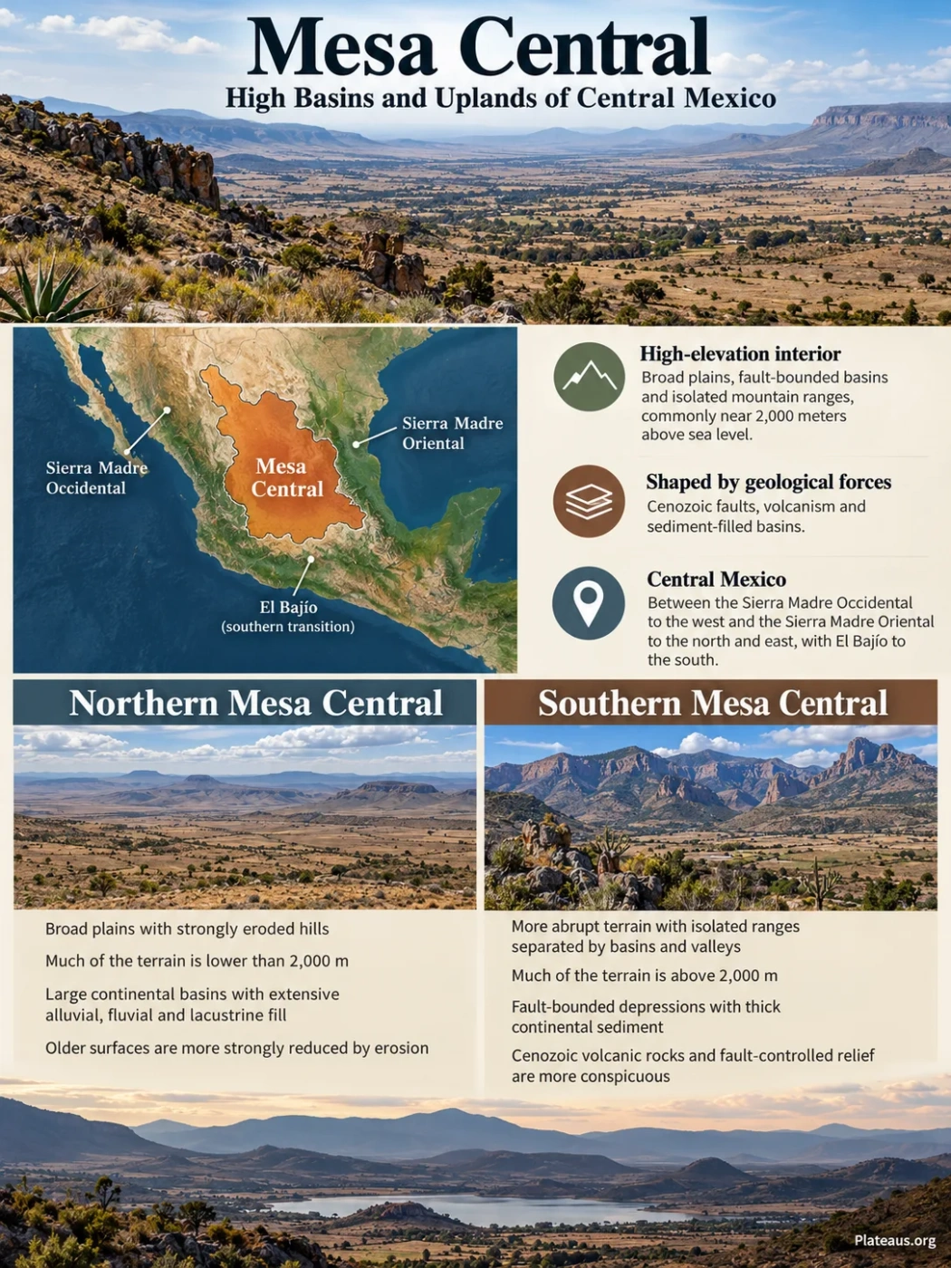
Central Mexico
Mesa Central is a high interior province of central Mexico where broad plains, fault-bounded basins, isolated mountain ranges and volcanic uplands occur at elevations commonly near 2,000 meters above sea level. Its landscape is not a single flat tabletop: the north is smoother and more deeply eroded, while the south is a higher, rougher mosaic of ranges and sediment-filled basins.
Northern plains and southern basin uplands
Cenozoic faults, volcanism and basin fill
Mesa Central Is a Specific Province, Not the Whole Mexican Plateau
The name Mesa Central has been used in more than one way in Mexican geography. Modern geological work commonly treats it as a defined physiographic province in central Mexico, while Mexican physiographic mapping also uses the closely related name Mesa del Centro. Both should be distinguished from the much larger Mexican Plateau or Altiplano Mexicano, which extends far north toward the United States border.
Name and Boundary Note
Mesa Central does not have one universal outline across geology, physiography, hydrology and biogeography. Boundary descriptions therefore vary with the classification being used. In geological treatments, fault systems and contrasts in landform are often more useful than state lines.
In a widely used geological definition, the province lies between the Sierra Madre Occidental to the west and the Sierra Madre Oriental to the north and east, with the El Bajío region forming its southern transition. Parts of the boundary are marked by major Cenozoic fault systems rather than by a simple mountain crest.
Sierra Madre Occidental and the Aguascalientes structural margin
High plains, basins, isolated ranges and volcanic uplands
Sierra Madre Oriental and related structural boundaries
The province crosses parts of several central Mexican states. Zacatecas, San Luis Potosí, Aguascalientes and northern Guanajuato contain some of its clearest basin-and-upland landscapes, while broader physiographic schemes extend the Mesa del Centro into adjoining parts of Durango, Jalisco, Querétaro and Coahuila.
The Plateau Has Two Distinct Landscapes
The most useful way to understand Mesa Central is to separate its northern and southern sectors. The difference is visible in digital elevation models and in the field: one sector is dominated by subdued plains and worn-down hills, while the other retains sharper mountain blocks and more clearly enclosed basins.
| Landscape Trait | Northern Mesa Central | Southern Mesa Central |
|---|---|---|
| General relief | Broad plains with strongly eroded hills and subdued relief | More abrupt terrain with isolated ranges separated by basins and valleys |
| Elevation pattern | Much of the terrain is lower than 2,000 m | Much of the terrain is above 2,000 m, apart from lower depressions such as the Aguascalientes valley |
| Basin character | Large continental basins with extensive alluvial, fluvial and lacustrine fill | Fault-bounded depressions between ranges, commonly with thick continental sediment |
| Rock expression | Older surfaces are more strongly reduced by erosion | Cenozoic volcanic rocks and fault-controlled relief are more conspicuous |
This contrast explains why the word mesa can be misleading. Mesa Central is elevated as a region, but its surface contains internal differences of hundreds of meters. A basin floor can be locally low relative to a nearby range and still stand well above sea level.
The San Luis–Tepehuanes Fault System Separates the Two Sectors
The boundary between the northern and southern landscapes is tied to the San Luis–Tepehuanes fault system, a broad structural zone that runs northwest across the province. It has been documented from the San Luis de la Paz area in Guanajuato toward Tepehuanes in Durango, although satellite imagery suggests that related structures may continue beyond the mapped limits.
Between San Luis de la Paz and Salinas de Hidalgo, the fault system is roughly 30 kilometers wide and consists of numerous northwest-trending normal faults. Different segments record activity from the Eocene into the Quaternary, so it should not be imagined as one fault that moved once. It is a long-lived belt of weakness within the crust.
Smoother plains, eroded hills and broad sedimentary basins
Northwest-trending normal faults and intersecting structures
Higher terrain, volcanic rocks, mountain blocks and fault-bounded valleys
The structural zone also intersects other fault systems, including the Aguascalientes graben. These crossings help explain why the plateau contains abrupt changes in basin shape, range orientation and bedrock exposure rather than a single repeated north–south pattern.
Why High Basins Form Inside Mesa Central
Many of the province’s broad valleys began as tectonic depressions. During Cenozoic crustal extension, normal faults displaced blocks of rock downward to form grabens and half-grabens. Erosion then moved debris from the surrounding ranges into those depressions.
The crust stretches and normal faults divide it into moving blocks.
Some blocks drop relative to neighboring uplands, creating structural depressions.
Streams and slope processes carry gravel, sand, silt and clay from the ranges toward basin floors.
Repeated filling creates broad, relatively flat surfaces that remain high above sea level.
The fill is not uniform. Near mountain fronts, coarse alluvial-fan gravel is common. Farther into the basins, finer river and lake deposits can dominate. Some depressions preserved shallow lakes or playas at different stages, leaving lacustrine beds mixed with alluvium and volcanic material.
A Basin Floor Can Still Be a Highland
The San Luis Potosí basin shows this clearly. Its valley floor averages about 1,840 meters above sea level, yet surrounding ranges rise to roughly 2,200–2,700 meters. The basin is a topographic low within Mesa Central, but it is still a high-elevation interior basin on a continental scale.
Bedrock and volcanic upland; runoff and sediment source
Alluvial fans spread outward from mountain fronts
Thick fluvial, lacustrine and alluvial sediment can bury the older bedrock surface
Another faulted upland closes or partly encloses the depression
Three Areas Show the Basin-and-Upland Pattern Clearly
Ojuelos–Aguascalientes
Broad Plains Broken by Low Ranges and Mesas
Eastern Aguascalientes belongs to the Llanuras de Ojuelos–Aguascalientes physiographic subprovince. The terrain includes plains with hills, mesas, valleys and low ranges. It is one of the clearest places to see how a plateau can be open and relatively level without being perfectly flat.
San Luis Potosí
A High Endorheic Basin
The San Luis Potosí valley is a closed interior basin bordered by the Sierra de San Miguelito, Sierra de Álvarez and other volcanic or mountainous uplands. Alluvial and lacustrine deposits bury the irregular bedrock floor beneath the modern valley.
Zacatecas–Salinas
Volcanic Highlands Feeding Sediment-Filled Basins
Rhyolitic and ignimbritic uplands border sediment-filled basins around Zacatecas and Salinas. Fractured volcanic rocks act as recharge areas, while basin fills store groundwater and record long periods of erosion, transport and deposition.
These examples also show why state boundaries are poor substitutes for landform boundaries. Aguascalientes alone contains terrain assigned to Mesa del Centro, Sierra Madre Occidental and the Trans-Mexican Volcanic Belt. The transition from one province to another follows relief, bedrock and structure rather than administrative lines.
The Modern Surface Records Several Geologic Stages
Mesa Central did not form in one episode. Older sedimentary rocks, mountain-building deformation, Cenozoic volcanism, long-lived faulting and repeated basin filling all contribute to the present relief.
Marine and Continental Sedimentary Sequences Accumulate
Large parts of the region were occupied by marine environments during portions of the Jurassic and Cretaceous, producing thick sedimentary successions that now form part of the deeper geological foundation.
Compression Folds and Faults the Older Rocks
Mountain-building associated with the Mexican segment of the Laramide orogeny deformed the older strata before the later plateau basins took shape.
Extension and Felsic Volcanism Reshape the Region
Normal faulting became widespread while large volumes of rhyolitic and ignimbritic volcanic rocks were emplaced. Fault-controlled depressions began to develop and receive continental sediment.
Basins Continue to Fill During Long-Lived Extension
Fluvial and lacustrine sediment accumulated in grabens and half-grabens as erosion lowered surrounding uplands and broadened valley floors.
Younger Basaltic Volcanism Appears Locally
Later alkaline basaltic activity was smaller in volume than the earlier felsic volcanism. Much of Mesa Central now shows subdued tectonic relief, although localized Pliocene–Quaternary magmatism and seismicity have been documented in parts of Durango and San Luis Potosí.
The result is a layered landscape. Some ridges expose folded Mesozoic rocks, others are built from Cenozoic volcanic sequences, and many basin floors hide those older units beneath thick continental deposits.
Volcanic Rocks Shape the Uplands Without Forming One Continuous Lava Table
Volcanic rocks are widespread across Mesa Central, especially in the south, but the province should not be treated as a single lava plateau. Rhyolite, ignimbrite, volcanic tuff and younger basalt occur alongside older sedimentary rocks and thick basin deposits.
This mixed geology matters for relief. Resistant volcanic units can form mesas, ridges and uplands, while faulted depressions next to them collect sediment and develop smoother surfaces. In places, the contact between volcanic bedrock and basin fill is buried hundreds of meters below the present plain.
Drainage Is Controlled by Basins, Divides and Subsurface Pathways
Closed drainage is an important part of Mesa Central, but it does not describe the entire province. Some basins are endorheic, meaning surface water remains within the basin and is lost mainly through evaporation or infiltration. Other areas connect to larger outward-draining river systems.
Even where a basin appears closed at the surface, groundwater can follow a different geometry. Water enters fractured volcanic highlands, moves through faults and permeable units, and may pass beneath surface drainage divides before reaching basin-fill aquifers or discharge zones.
Surface Basin and Groundwater Basin Are Not Always the Same
A topographic divide controls where surface runoff flows, but fractures, buried faults and connected aquifers can allow groundwater to cross beneath that divide. Mesa Central therefore cannot be understood from surface contours alone.
In the San Luis Potosí basin, for example, volcanic and alluvial units form a layered aquifer system beneath a closed valley. In Zacatecas and Salinas, hydrogeologic studies likewise distinguish shallow local flow from deeper regional flow through volcanic rocks and basin sediments.
Semi-Arid Conditions Emphasize the Relief
Much of Mesa Central has a semi-arid climate with a strong summer-rainfall season. Dry months reduce permanent surface flow across many basin floors, while short periods of heavier rain can activate ephemeral channels and carry fresh sediment from mountain fronts onto alluvial fans.
Elevation prevents the province from behaving as one uniform dry lowland. Higher ranges are generally cooler and can receive more moisture than adjoining basin floors. This produces short-distance transitions from open grassland and xeric shrubland on plains to denser woodland on some higher slopes.
The climatic pattern also helps preserve the basin-and-range appearance. Sparse or seasonal surface flow leaves broad alluvial surfaces exposed, while vegetation and soil conditions change with altitude, slope direction, bedrock and access to groundwater.
Modern Groundwater Chemistry Still Reflects the Plateau’s Geology
Hydrogeologic work in the Zacatecas and Salinas areas shows that the plateau’s geology continues to affect water long after the basins formed. Groundwater moving through felsic volcanic rocks and sediments derived from them can acquire naturally occurring fluoride, arsenic and uranium through weathering and prolonged water–rock interaction.
The concentrations are not uniform from one aquifer or well to another. Shallow local groundwater can have shorter contact with the rock, while deeper regional flow may circulate for much longer periods through rhyolite, ignimbrite and basin-fill sediment. In the Zacatecas study area, groundwater-flow modeling has identified regional water with residence times greater than 8,000 years.
This hydrogeologic pattern connects several physical parts of Mesa Central: volcanic uplands receive recharge, faults provide pathways, sediment-filled basins store groundwater, and long flow paths allow the chemistry of the rocks to leave a measurable record in the water.