Northern Mexican Plateau · Interior Basins · Chihuahuan Desert
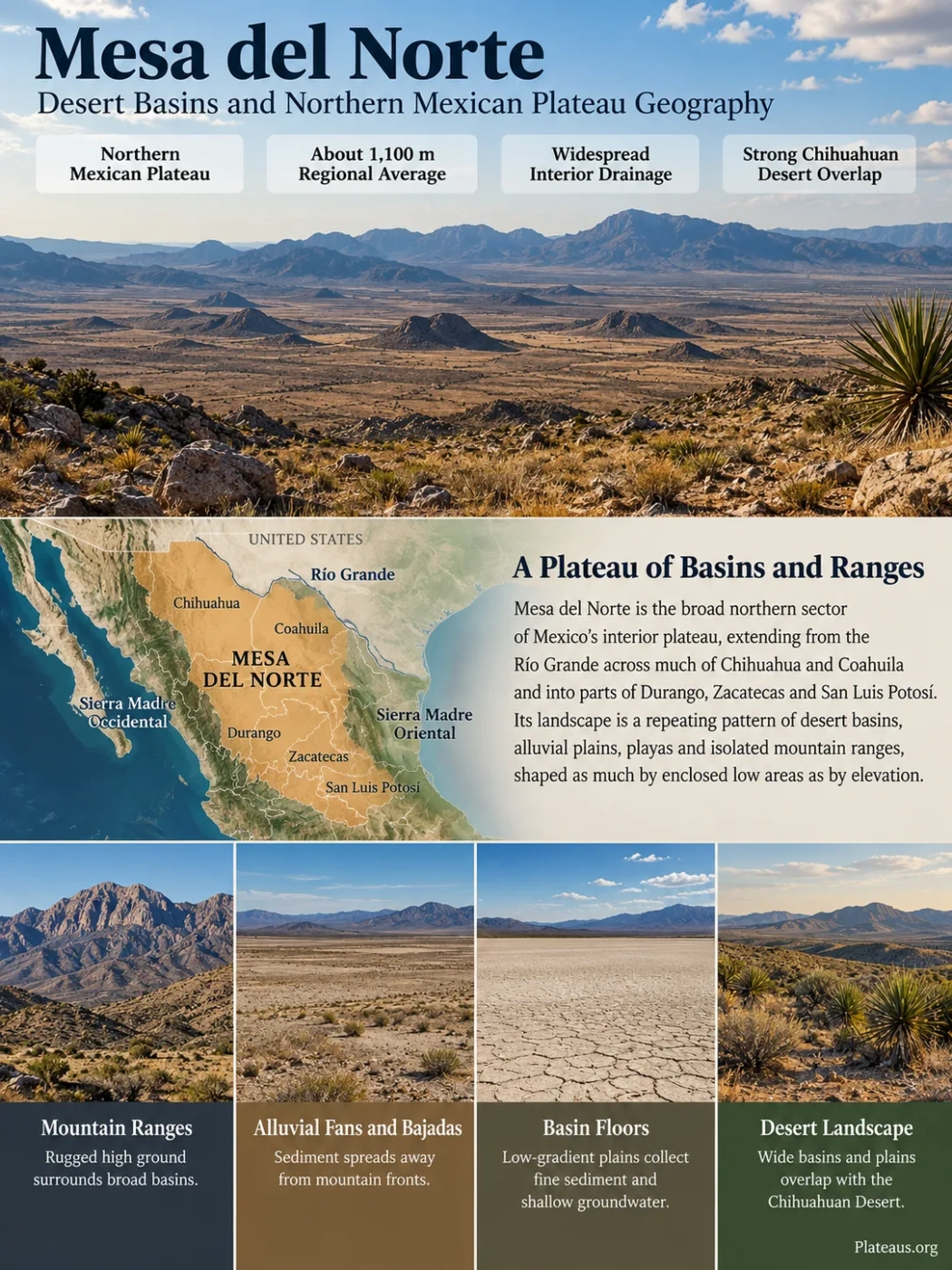
Mesa del Norte is the broad northern sector of Mexico’s interior plateau, extending south from the Río Grande across much of Chihuahua and Coahuila and into parts of Durango, Zacatecas and San Luis Potosí. Its defining landscape is not a single flat tableland. Wide desert basins, alluvial plains, playas and isolated mountain ranges repeat across the region, creating a plateau whose geography is shaped as much by enclosed low areas as by elevation.
About 1,100 m Regional Average
Widespread Interior Drainage
Strong Chihuahuan Desert Overlap
Mesa del Norte Is a Physical Region, Not a Fixed Administrative Unit
The name Mesa del Norte, meaning northern plateau or northern tableland, is a traditional geographic term for the northern part of the Mexican Plateau, also called the Mexican Altiplano. It begins around the Río Grande, or Río Bravo del Norte, and extends south through the dry interior between Mexico’s two major Sierra Madre systems.
The broad western side is framed by the Sierra Madre Occidental, while the Sierra Madre Oriental forms the main mountain system to the east. Between them lies a wide interior of basins, plains and smaller ranges. Chihuahua and Coahuila contain much of the clearest northern plateau terrain, while the traditional regional concept continues southward into Durango, Zacatecas and San Luis Potosí.
Sierra Madre Occidental and adjoining volcanic uplands
Bolsons, desert plains, playas, alluvial basins and isolated ranges
Sierra Madre Oriental and related folded mountain belts
The limits are transitional rather than surveyed boundaries. A mountain range may belong to an adjoining physiographic province while its piedmont slopes merge gradually into a basin traditionally described as part of Mesa del Norte. Political boundaries provide useful orientation but do not define the landform.
Name and Classification Note
Mesa del Norte remains useful as a regional geographic term, but modern Mexican physiographic mapping does not simply use it as one province with one fixed outline. INEGI recognizes Sierras y Llanuras del Norte as a major physiographic province across parts of Chihuahua, Coahuila and Durango, alongside neighboring provinces such as the Sierra Madre Occidental, Sierra Madre Oriental and Mesa del Centro. The traditional Mesa del Norte concept is therefore broader than one modern map label.
The Plateau Is a Repeating Pattern of Basins and Ranges
Seen at continental scale, Mesa del Norte looks like a large elevated interior. At ground level, the surface is far less uniform. Long mountain ridges rise above broad low-relief plains, while sediment-filled depressions occupy the spaces between them.
Runoff and rock debris move away from mountain fronts and spread across alluvial fans. Where neighboring fans join, they form broad sloping aprons commonly called bajadas. Finer sediment travels farther toward the lowest parts of enclosed basins, where clay-rich flats and temporary lake beds can develop.
Rocky high ground supplies runoff and sediment.
Gravel, sand and finer material spread away from the mountain front.
Low-gradient plains collect fine sediment and shallow groundwater.
The lowest enclosed ground may hold temporary water before drying.
This pattern explains why the word plateau can be misleading if it is imagined as one flat rock surface. Mesa del Norte is better understood as an elevated regional base containing many smaller topographic units.
Some basin floors extend for long distances with only gentle changes in elevation. The mountains between them may rise abruptly, creating several hundred metres or more of local relief. Individual ridges can stand far above the commonly cited average elevation of the northern plateau.
Elevation Varies Much More Than the 1,100-Metre Average Suggests
Mesa del Norte is often described as averaging roughly 1,100 metres above sea level. That figure is useful for distinguishing the northern plateau from the generally higher interior farther south, but it should not be treated as the height of one continuous surface.
Broad basin floors commonly occupy the lower elevations of the region. Mountain blocks and narrow ranges rise well above them, with many summits exceeding 2,000 metres. Elevation can therefore change sharply over a relatively short horizontal distance even though the wider region appears plateau-like on a small-scale map.
Elevation Note
There is no useful single “highest point of Mesa del Norte” unless a particular boundary definition is chosen first. Some high ridges are treated as interior ranges, while others belong to neighboring Sierra Madre provinces. Plateau elevation, basin-floor elevation and mountain-summit elevation should not be treated as the same measurement.
Bolsón de Mapimí Shows How the Northern Plateau Works
The Bolsón de Mapimí is one of the clearest expressions of Mesa del Norte’s basin-dominated geography. It occupies a large part of the interior around the meeting area of Chihuahua, Coahuila and Durango and is commonly described as the largest major depression of the northern plateau.
A bolsón is not simply a deep bowl with one rim. In northern Mexico the term commonly refers to a broad enclosed or partly enclosed desert basin system surrounded and subdivided by mountain ranges. The Bolsón de Mapimí includes plains, playas, dunes, alluvial slopes, grassland and shrubland as well as rocky uplands.
The lowest ground receives sediment and intermittent runoff from surrounding slopes. Water may briefly spread over shallow depressions after storms, but high evaporation and the absence of a continuous route to the sea prevent permanent surface drainage across much of the area.
Short storms produce runoff on steep rocky slopes.
Coarse material is deposited on fans while finer sediment travels farther.
Channels may weaken or disappear as water spreads, infiltrates or reaches a playa.
Fine sediment and dissolved salts can remain after temporary water disappears.
Much of the Water Never Reaches the Sea
Drainage is one of the features that most clearly separates Mesa del Norte from a simple sloping plateau. Large parts of the interior are endorheic: runoff flows toward internal depressions rather than entering a river that eventually reaches an ocean.
The pattern is not universal. The northern plateau also includes externally drained areas. The Río Conchos, one of northern Mexico’s major rivers, joins the Río Grande and ultimately belongs to a Gulf of Mexico drainage system. Parts of the southeastern plateau connect toward the Pánuco basin.
Between these externally drained areas are many closed basins where streams are short, intermittent or lost before reaching another river. Some channels end on permeable alluvial surfaces. Others reach a playa, shallow lagoon or saline depression.
External Drainage
River systems such as the Río Conchos carry water out of parts of the plateau and into the Río Grande basin.
Internal Drainage
Many desert channels terminate within bolsons, where water infiltrates or evaporates instead of reaching the sea.
Groundwater Transfer
Water can also move beneath basin floors through permeable gravel and sand even where no permanent surface stream exists.
Playas Record Water in a Landscape That Usually Looks Dry
The flattest parts of closed basins may contain playas, locally also described as barreales. These are low areas where fine clay and silt accumulate. After heavy rainfall they may hold shallow temporary water; during long dry periods they can appear as pale, almost featureless flats.
Because water leaves many of these basins mainly through evaporation or infiltration, dissolved minerals can become concentrated. Repeated wetting and drying helps create saline soils, salt crusts and evaporite-rich deposits in suitable depressions.
The modern dry landscape also preserves evidence of larger former lake systems. The Nazas and Aguanaval rivers historically delivered water into closed basins of the Comarca Lagunera, including the Laguna de Mayrán system. River regulation, irrigation demand and the region’s arid climate have greatly reduced the frequency and extent of water reaching many former lake beds.
This history helps explain an apparent contradiction: a desert plateau can contain extensive lake sediments even where permanent lakes are absent today. The sediments record earlier hydrologic conditions, repeated flooding and the movement of water through an enclosed basin rather than a permanently wet climate.
The Geology Changes From Mountain Fronts to Basin Floors
Mesa del Norte should not be described as a single volcanic plateau. Its geology is mixed because the region lies between major mountain systems and has been affected by several periods of deformation, faulting, volcanism, erosion and sediment accumulation.
Western sectors approach the volcanic terrain of the Sierra Madre Occidental, where thick volcanic sequences form high uplands. Farther east, many ranges expose sedimentary rocks, including Mesozoic limestone, shale and related units that were folded and faulted during mountain-building episodes.
Later crustal extension and fault movement helped organize parts of northern Mexico into alternating ranges and depressions. Erosion then supplied enormous volumes of debris to the basins. Over long periods, gravel, sand, silt and clay filled low areas and softened the relief between mountain blocks.
Volcanic, sedimentary and older basement rocks form the resistant uplands and ranges.
Crustal movement helped separate elevated blocks from lower structural basins.
Weathering and erosion moved sediment from ranges into depressions over long periods.
Alluvial plains, fans, playas and isolated ranges now form the characteristic terrain.
The thick sediment under some basin floors is more than a surface feature. Coarse layers of sand and gravel can store and transmit groundwater, while clay-rich layers slow its movement. This hidden basin fill is central to both the hydrogeology and human use of the northern plateau.
The Chihuahuan Desert Covers Much of the Plateau but Is Not the Same Region
Much of northern Mesa del Norte lies within the Chihuahuan Desert, but the two names describe different kinds of geography. Mesa del Norte is a physiographic and regional landform concept. The Chihuahuan Desert is an ecological and climatic region whose boundaries extend beyond the plateau.
Mesa del Norte
- A northern division of the Mexican interior plateau in traditional geography.
- Defined mainly through relief, elevation, basins and surrounding mountain systems.
- Includes desert terrain but is not defined only by vegetation or climate.
Chihuahuan Desert
- An arid ecological region extending across northern Mexico and into the United States.
- Defined through climate, vegetation, habitats and biogeographic patterns.
- Overlaps strongly with Mesa del Norte but extends beyond it.
Desert shrublands containing creosote bush, lechuguilla, yucca, agaves, mesquite and many cactus species cover large areas. Yet the northern plateau is not one continuous shrub desert. Open grasslands, shrub-grass mosaics, dune systems, saline flats and seasonally wet depressions break up the landscape.
Higher interior ranges create another layer of variation. Cooler conditions and greater local moisture can support woodland on elevated slopes even when the surrounding basin is dry. These uplands act as ecological islands above the desert floor.
Summer Rain Can Reshape an Arid Basin in a Few Hours
Aridity dominates Mesa del Norte, but rainfall is not absent. Much of the region receives an important share of its annual precipitation during the warm season, when moist air and summer thunderstorms can produce short, localized downpours.
These storms matter because bare or sparsely vegetated slopes can shed water quickly. An arroyo that remains dry for much of the year may carry a strong flow after intense rain. Water spreads onto alluvial fans, transports fresh sediment and occasionally reaches playas that appeared completely dry days earlier.
Winter weather follows a different pattern. Northern air masses can bring cold conditions to an interior already elevated well above sea level. Clear skies, dry air and large differences between daytime and nighttime temperature are common features of many basin environments.
Elevation also produces local climate contrasts. A warm basin floor and a nearby mountain slope can experience different temperatures, vegetation and moisture conditions even though they lie within the same broad plateau region.
Groundwater Is Stored Beneath the Bolsons
The sediment-filled basins of Mesa del Norte contain many of the region’s most useful aquifers. Water entering mountain fronts can infiltrate fractured rock, stream channels, gravel fans and coarse alluvial deposits before moving beneath the basin floor.
This produces a basic hydrogeologic pattern: recharge is often concentrated near mountain margins, while pumping commonly occurs farther into populated or cultivated basins. The aquifer is therefore connected to the surrounding topography even when the water is no longer visible at the surface.
Rain and runoff enter fractures, coarse channels and fan deposits.
Sand and gravel layers beneath the basin can store and transmit groundwater.
Wells support towns, livestock and irrigated agriculture where surface water is unreliable.
Water quality is not uniform. Long residence times, evaporation, contact with mineral-rich sediments and movement through saline basin deposits can raise dissolved mineral concentrations. Some north-central Mexican aquifers also face localized problems involving salinity or naturally occurring trace elements.
Heavy pumping adds another pressure. In an arid landscape, groundwater recharge may be slow compared with extraction from agricultural and urban wells. The result can vary widely between basins, so conditions should be assessed aquifer by aquifer rather than applied to Mesa del Norte as one groundwater system.
Basins Concentrate Farming, Roads and Settlement
The same landforms that organize water also influence where people can build, travel and farm. Broad basin floors provide gentler terrain than the intervening mountain ranges. Roads and rail corridors can follow these open surfaces or pass through gaps between ranges instead of crossing steep uplands.
Agriculture is concentrated where soils, river water or groundwater make cultivation possible. Irrigated fields can therefore form sharply defined green zones within otherwise dry basins. The Comarca Lagunera around Torreón, Gómez Palacio and Lerdo is one of the clearest examples of intensive settlement and agriculture developed within an arid interior drainage setting.
Mountain geology creates a different pattern of resource use. Northern Mexico has long contained mining districts associated with particular volcanic, intrusive and sedimentary rock belts. Silver, lead, zinc, copper and other ores occur in specific geological zones rather than being evenly distributed beneath the plateau.
This unevenness is characteristic of Mesa del Norte: flat basins favor transport, settlement and irrigated agriculture, while ranges contain many of the exposed rock resources and steeper grazing lands.
Mesa del Norte and Mesa del Centro Are Different Parts of the Mexican Interior
Traditional regional geography divides the Mexican Plateau into a northern Mesa del Norte and a higher southern section generally called Mesa del Centro or Mesa Central. The transition is gradual in some places, but the contrast remains useful for understanding Mexico’s interior relief.
| Feature | Mesa del Norte | Mesa del Centro |
|---|---|---|
| Position | Northern Mexican interior | Farther south in the Mexican interior |
| General Elevation | Lower overall; a regional average near 1,100 m is often cited | Generally higher than the northern plateau |
| Characteristic Relief | Wide bolsons, desert plains, playas and isolated ranges | Higher basins, uplands, valleys and mountain-bordered plains |
| Drainage | Large areas of internal drainage alongside external river basins | Different mix of enclosed basins and externally drained systems |
| Ecological Setting | Strongly associated with Chihuahuan Desert landscapes in the north | More varied central Mexican highland environments |
The distinction should not be treated as a hard line crossing the country. Modern physiographic systems divide the Mexican interior using more detailed provinces and subprovinces, while Mesa del Norte and Mesa del Centro remain useful broad regional names.
The Landscape Can Be Read Directly From Satellite Patterns
Mesa del Norte’s structure is especially clear from above because the same forms repeat over large distances. Dark or rugged linear features commonly mark mountain ranges, while lighter and smoother areas between them represent alluvial basin floors.
- Triangular or fan-shaped deposits at mountain fronts often indicate alluvial fans.
- Broad coalescing slopes around basin margins are typical bajadas.
- Very pale, smooth basin centers may mark playas, saline flats or fine lake-bed sediment.
- Channels that fade across a plain can indicate interior drainage where runoff infiltrates or spreads before reaching a permanent river.
- Geometric green fields within dry terrain usually show irrigated agriculture supported by river diversions or groundwater.
- Darker high-elevation vegetation on isolated ranges can reveal cooler or wetter ecological zones above desert basins.
These patterns make Mesa del Norte recognizable even without a political map. Its geographic identity comes from the repeated relationship between mountain blocks and the enclosed plains below them.
Mapimí Protects a Rare Desert Grassland and Basin Ecosystem
The Mapimí Biosphere Reserve protects about 342,000 hectares across parts of Durango, Chihuahua and Coahuila. Its landscape includes desert grassland, shrubland, dunes, basin floors and low mountain ranges representative of the southern Bolsón de Mapimí.
One of its best-known animals is the Bolson tortoise (Gopherus flavomarginatus), an endangered species with a naturally restricted distribution centered on the Mapimí region. The tortoise depends heavily on desert grassland and suitable soils in which it can excavate deep burrows for shelter from temperature extremes.
Grassland condition is therefore tied directly to wildlife conservation. Long-term grazing pressure and conversion of land for agriculture can reduce native grass cover, alter soil surfaces and fragment habitat. Restoration work has used livestock exclusion and small-scale water and soil treatments to help native vegetation recover in tortoise habitat.
Current reserve management also includes work with local communities around regenerative livestock practices, habitat protection and community-based tourism. These approaches reflect the geography of the reserve itself: conservation cannot be separated from grassland condition, groundwater use and the way ranching operates across the basin.
Why Mapimí Matters to Mesa del Norte
The reserve preserves more than a desert wildlife site. It contains the basin floor, alluvial slopes, grasslands, shrublands and interior ranges that make the broader Mesa del Norte landscape understandable as one connected physical system.