INTERACTIVE CONTEXT MAP
Where is Mexican Plateau?
The selected plateau and nearby mapped locations are shown. Open the full world atlas to explore every region.
Interior Highlands of Mexico
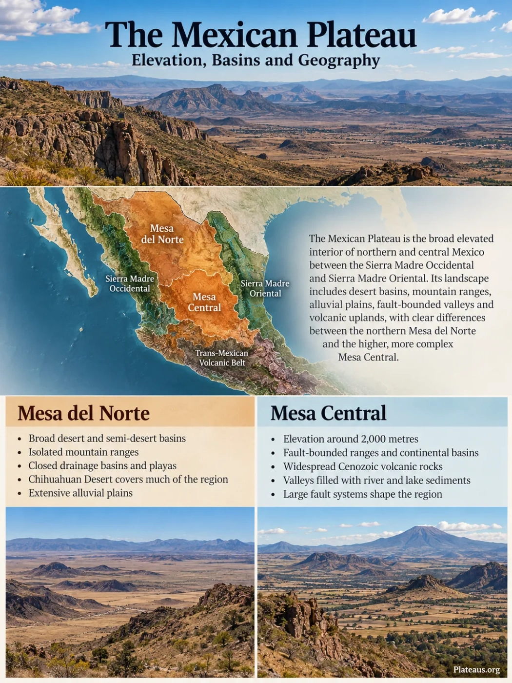
The Mexican Plateau is the broad elevated interior of northern and central Mexico between the Sierra Madre Occidental and Sierra Madre Oriental. Its surface is not a single flat tableland: desert basins, isolated mountain ranges, alluvial plains, fault-bounded valleys and volcanic uplands create a landscape that changes markedly from the northern Mesa del Norte to the higher and more structurally complex country farther south.
The Mexican Plateau Is a Regional Highland, Not One Flat Surface
The name Mexican Plateau is commonly used for the extensive interior highland between Mexico’s two main Sierra Madre ranges. The Sierra Madre Occidental forms the major mountain belt to the west, while the Sierra Madre Oriental rises along the eastern side. Toward central Mexico, the plateau approaches the volcanic and tectonic terrain of the Trans-Mexican Volcanic Belt.
That broad description is useful, but it can also create the wrong image. The plateau does not resemble an enormous level tabletop. Its interior contains mountain blocks, long ridges, sediment-filled basins, dry lake beds, alluvial fans, volcanic terrain and river valleys. Relief can be low across one basin floor and sharply mountainous only a short distance away.
Geography Note
Mexican Plateau, Mesa del Norte, Mesa Central and Mesa del Centro are not interchangeable names in every source. Mexican Plateau is a broad geographic term. Mexican official physiographic mapping divides the interior into more specific provinces, including Sierras y Llanuras del Norte and Mesa del Centro. Geological studies also use Mesa Central for a defined central Mexican province whose mapped limits depend on geomorphology, geology and major fault systems.
This difference in terminology matters when comparing maps. A general map labeled “Mexican Plateau” may cover a much broader interior highland than a scientific map labeled “Mesa Central.” Boundaries drawn for drainage, geology, physiography or ecology may also differ slightly because each classification is describing a different property of the landscape.
High volcanic mountain belt along the western side of the interior.
Elevated basins, plains, ridges and mountain blocks across the continental interior.
Folded and faulted mountain belt forming much of the eastern highland margin.
North and South Do Not Have the Same Landscape
The strongest geographic contrast within the Mexican Plateau is between its broad northern interior and the higher central uplands to the south. The northern region is commonly described as Mesa del Norte. Farther south, Mesa Central or Mesa del Centro appears in geographic and geological classifications, although the exact areas represented by those names vary.
Mesa del Norte
- Broad desert and semi-desert basins are widespread.
- Long isolated ranges rise above sediment-filled lowlands.
- Closed drainage basins and playas are common.
- The Chihuahuan Desert overlaps a large part of the region.
- Alluvial plains can extend for long distances between mountain blocks.
Mesa Central
- Much of the province lies around 2,000 metres above sea level.
- Fault-bounded ranges and continental basins are prominent.
- Cenozoic volcanic rocks cover large areas, especially in the south.
- Fluvial and lake sediments fill many valleys and grabens.
- Large fault systems help define both internal zones and outer margins.
Even Mesa Central is not uniform. Geological mapping distinguishes a northern sector with extensive plains and strongly eroded hills from a southern sector with more abrupt relief, isolated ranges and valleys filled with river and lake sediments. The contrast is partly structural: major fault systems divide blocks of crust that have experienced different patterns of uplift, extension, volcanism and erosion.
This makes elevation alone a poor way to describe the Mexican Plateau. A single average height hides much of its physical geography. Basin floors, mountain summits and volcanic uplands can differ by hundreds or even more than a thousand metres within the same broad plateau region.
Mesa del Norte Is a Country of Basins and Isolated Ranges
Across the northern plateau, especially in Chihuahua, Coahuila and Durango, the terrain repeatedly alternates between mountain ranges and broad sediment-filled basins. Many ranges are elongated rather than compact. Between them lie plains built from material eroded from the surrounding high ground.
Water and sediment move downslope from the mountains during storms. When streams emerge from confined mountain channels onto a wide basin floor, their velocity falls and they deposit gravel, sand and finer sediment. Repeated deposition builds alluvial fans, which can merge into broad aprons along the foot of a range.
Steeper slopes collect runoff and supply rock debris.
Streams spread outward and deposit sediment at the mountain front.
Fine sediment accumulates across flatter interior terrain.
The lowest closed part may temporarily hold water after rainfall.
These basins help explain why photographs and satellite images of the northern plateau can look very different from the usual idea of a plateau. Instead of a broad flat summit bounded by cliffs, much of the region resembles a repeated sequence of low basins and steep-sided ranges held within a larger elevated interior.
Bolsón de Mapimí Shows How Interior Drainage Works
The Bolsón de Mapimí, spanning parts of Durango, Chihuahua and Coahuila, is one of the clearest examples of the northern plateau’s basin geography. The Spanish term bolsón, meaning a large pocket or enclosed basin, is especially useful here because much of the drainage does not continue to the sea.
Low mountain ranges divide the landscape into sub-basins. Streams are often temporary, carrying water mainly after rainfall. Runoff moves from surrounding slopes toward lower ground, where it may soak into basin sediment, evaporate or collect temporarily in playas and shallow depressions.
Short-lived runoff forms on mountain slopes and rocky surfaces.
Channels leave mountain fronts and spread across alluvial fans.
In a closed basin there is no continuous river route to an ocean.
Dissolved minerals may remain behind while part of the water moves underground.
Repeated evaporation explains why saline soils, salt deposits and pale playa surfaces occur in parts of the northern plateau. Water entering a closed basin can carry dissolved minerals, but there is no permanent outlet to flush those minerals downstream to the sea. As water evaporates, salts become concentrated in the basin.
The Mapimí Biosphere Reserve occupies part of this closed-basin landscape within the Chihuahuan Desert. Its desert scrub, grasslands and dry basin terrain provide habitat for the Bolson tortoise (Gopherus flavomarginatus), an endemic species closely associated with this region of northern Mexico.
Not Every River on the Plateau Ends in a Closed Basin
Closed drainage is one of the most recognizable features of the Mexican Plateau, but it does not describe the entire region. The interior contains both endorheic basins, where water remains within the continental interior, and external drainage systems connected to rivers that ultimately reach the sea.
The Río Conchos provides an important contrast with the closed basins. It crosses Chihuahua and joins the Río Bravo, or Rio Grande, creating an outlet from part of the northern interior toward the Gulf of Mexico drainage system.
Elsewhere, rivers can terminate inside the plateau. The Nazas system historically carries water toward the closed Comarca Lagunera basin rather than to an ocean. Water reaching low-lying interior areas may disappear through evaporation, infiltration and human use before forming a permanent terminal lake.
| Drainage Setting | What Happens to Water | Typical Landforms or Features |
|---|---|---|
| Closed interior basin | Runoff remains within the basin and is lost mainly through evaporation or infiltration. | Playas, saline flats, alluvial fans and groundwater-filled basin sediment |
| Temporary desert drainage | Channels flow mainly after storms and may end before reaching a permanent water body. | Arroyos, dry channels and fan deposits |
| External river drainage | Water crosses or leaves the plateau through a connected river system. | Integrated valleys and tributary networks such as the Río Conchos system |
The mixture of internal and external drainage is one reason a single description such as “the Mexican Plateau has no outlet to the sea” is too broad. Drainage changes from basin to basin and depends on topography, fault structure, river capture, sediment accumulation and the position of mountain divides.
Mesa Central Is Higher and More Structurally Broken
South of much of the desert basin country, the central Mexican interior becomes higher and geologically more complex. Modern geological work on Mesa Central describes it as an elevated physiographic province averaging roughly 2,000 metres above sea level, while also stressing that its northern and southern sectors have different terrain.
The Northern Part Has Broader, More Eroded Surfaces
The northern part of Mesa Central contains extensive plains, eroded hills and continental basins. In many areas, younger sediment hides older bedrock beneath the lowlands. These basin fills record repeated episodes of erosion, river deposition and lake sedimentation.
The Southern Part Is More Mountainous
Farther south, relief becomes more abrupt. Individual mountain ranges are separated by fault-controlled valleys and sediment-filled depressions. Cenozoic volcanic rocks are also more extensive across the southern sector, adding lava, ignimbrite and other volcanic units to an older geological foundation.
A major structure known as the San Luis–Tepehuanes fault system helps separate these contrasting northern and southern domains. It is not a single narrow crack. It is a broad fault zone composed of many structures that developed and moved at different times.
Large Fault Systems Help Define the Mesa Central
Mesa Central is unusual among broad plateau regions because several of its geographic limits can be related to mapped fault systems. These structures also cut through the interior, divide areas with different topography and influence the position of grabens and sedimentary basins.
Internal Division
San Luis–Tepehuanes
A broad northwest-trending fault system that helps separate the northern and southern morphological sectors of Mesa Central.
Eastern Margin
Taxco–San Miguel de Allende
A major zone of normal faults associated with the structural transition between Mesa Central and terrain toward the Sierra Madre Oriental.
Southern Margin
El Bajío Fault System
A fault system associated with the southern structural boundary of Mesa Central and the transition toward the Bajío region.
Western-Southern Structure
Aguascalientes Graben
A fault-bounded depression that forms part of the structural pattern along the western side of the southern Mesa Central.
Normal faulting lowered some crustal blocks while leaving adjacent blocks relatively high. Sediment then accumulated in the resulting depressions. Over long periods, erosion softened the relief of older ranges while younger basins continued to collect river, lake and alluvial deposits.
The resulting topography is better described as a faulted plateau-and-basin system than as one intact elevated slab.
The Plateau Records Several Different Stages of Geological Change
The Mexican Plateau did not form in one event. Different parts of the region preserve different histories, but Mesa Central shows particularly well how older marine rocks, mountain building, volcanism, crustal extension and basin sedimentation can overlap in the same landscape.
Marine Sediments Accumulate
Parts of the region lay within marine environments where limestone, shale, sandstone and related sedimentary rocks formed. Many of these rocks were later folded, uplifted, faulted or exposed by erosion.
Compression Builds the Mexican Orogen
Laramide-age deformation shortened and uplifted large parts of northern and central Mexico. Older sedimentary rocks were folded and faulted as regional mountain belts developed.
Extension and Volcanism Reshape the Interior
Crustal extension produced normal faults, while large volumes of volcanic rock were erupted across parts of central and western Mexico. Faulting and volcanism often occurred during overlapping intervals.
Grabens and Continental Basins Develop
Fault-controlled depressions accumulated clastic sediment transported from nearby highlands. Some basins also held lakes, leaving fluvial-lacustrine deposits beneath later surfaces.
Erosion, Sedimentation and Local Tectonic Activity Continue
Alluvial fans, river deposits and playa sediments continue to modify basin floors. Most of Mesa Central is strongly eroded, although younger volcanism and documented seismicity occur in parts of Durango and San Luis Potosí.
Landform Note
Calling the Mexican Plateau an “uplifted plateau” is not wrong at a broad scale, but it is incomplete. The modern surface combines regional elevation with folding, volcanic construction, normal faulting, erosion and the filling of tectonic basins.
Volcanism Is Part of the Plateau Story, but It Did Not Build the Whole Plateau
Volcanic rocks are widespread in parts of the Mexican interior, especially around Mesa Central and along its western and southern surroundings. The nearby Sierra Madre Occidental preserves one of the world’s largest regions of Cenozoic silicic volcanic rocks, and its volcanic history overlaps with the tectonic evolution of the western Mesa Central.
Within Mesa Central, Oligocene volcanic sequences include rhyolitic and other felsic rocks as well as volcanic units associated with periods of crustal extension. In places such as Pinos in Zacatecas, geological mapping shows that volcanic eruptions and normal faulting occurred during overlapping periods rather than as completely separate episodes.
Older marine sedimentary rocks remain exposed in other sectors, while younger continental sediment fills many valleys. The plateau therefore contains a mosaic of sedimentary, volcanic and intrusive rocks rather than a single volcanic cap.
The Trans-Mexican Volcanic Belt farther south is also a separate regional feature. It should not be treated as simply the southern part of the Mexican Plateau, even though the two geographic systems meet and interact along their margins.
The Chihuahuan Desert Covers Much of the North, Not the Entire Plateau
A large part of the northern Mexican Plateau lies within the Chihuahuan Desert, which extends across northern Mexico and into the southwestern United States. This overlap explains the widespread desert scrub, grasslands, playas and sparsely vegetated basin surfaces visible across northern Chihuahua, Coahuila and parts of Durango.
The two regions are not identical. The Mexican Plateau is a landform and physiographic concept; the Chihuahuan Desert is an ecological and climatic region. Their boundaries are defined for different reasons.
Moving southward and upward, the landscape passes through semi-arid grasslands, shrublands, cultivated basins and higher mountain environments. Local elevation can also create cooler conditions and different vegetation on isolated ranges rising above dry basin floors.
Common Mix-Up
Mexican Plateau does not mean Chihuahuan Desert. The desert occupies a large part of the northern plateau, while the broader highland extends into landscapes with different climates, vegetation, elevation and geology.
Elevation Changes the Meaning of “Desert Climate”
Much of the northern plateau is arid or semi-arid, but low rainfall does not mean every part of the region has the same temperature pattern. Large areas stand well above nearby coastal lowlands, and elevation can produce cool nights, cold winter conditions and frost even where daytime sunshine is strong.
The surrounding mountain systems also influence moisture movement. The Sierra Madre Occidental and Sierra Madre Oriental interrupt air masses approaching the continental interior, while distance from the oceans, latitude, seasonal circulation and topography all affect local rainfall. The dryness of the plateau is therefore not produced by one simple rain-shadow effect.
Mountain ranges inside the plateau add another layer of variation. Air forced upward along slopes cools, and higher terrain may receive more precipitation than nearby basin floors. As a result, a dry basin and its bordering range can support noticeably different soils and vegetation despite lying only a short distance apart.
Groundwater Lies Beneath Many of the Basin Floors
The same sediment-filled basins that shape the visible landscape also form important groundwater systems. Gravel, sand and other basin-fill deposits can store water that infiltrates from rainfall, temporary streams and runoff along mountain fronts.
Recharge is uneven. Mountain-front zones may receive more infiltration than central playa surfaces, while thick fine-grained sediment can slow groundwater movement. Faults can also alter underground flow by creating pathways in some places and barriers in others.
This hidden water system matters across dry parts of Chihuahua, Coahuila, Durango and the central plateau because cities, farming districts and rural communities can depend heavily on wells. Official Mexican groundwater assessments show that conditions vary sharply between aquifers: some retain calculated availability, while others have extraction and committed discharge greater than estimated recharge.
Groundwater Pressure
Northern plateau aquifers should not be treated as one underground reservoir. Each basin has its own recharge, pumping, natural discharge and storage conditions. Several aquifers across Coahuila and the Comarca Lagunera are recorded with negative annual groundwater availability, while others retain positive balances. The contrast follows the basin-by-basin structure of the plateau itself.
Groundwater use can also change what is visible at the surface. Irrigated fields may form geometric green patterns across otherwise dry basin floors, while permanent surface water remains scarce. The contrast is one of the clearest ways human water use has become part of the modern plateau landscape.
Faults Also Help Explain the Plateau’s Mining Districts
The relationship between geology and human use is especially visible in Mesa Central. Many known epithermal mineral deposits occur along or close to its large fault systems. Fault zones provided pathways through which magma and hydrothermal fluids could move through the crust, although the exact relationship between individual structures and particular deposits differs from place to place.
The western half of Mesa Central contains numerous Oligocene mineral districts associated with a period of widespread volcanism and faulting. Areas around Zacatecas, Durango and San Luis Potosí preserve examples where mineralization, volcanic rocks and large structural zones occur close together.
This helps explain why historic mining regions are not randomly scattered across the highland. The location of many silver, gold, lead, zinc, tin and fluorite occurrences reflects the same tectonic structures that helped divide the plateau into ranges and basins.
Basins Also Guide the Pattern of Cities, Roads and Farmland
Mountain ranges define much of the plateau’s relief, but many large settlements occupy the lower terrain between them. Broad basin floors provide flatter land for roads, urban growth and agriculture, while thick alluvial deposits may contain groundwater.
Chihuahua lies within the northern interior where valleys and basin terrain interrupt surrounding ranges. Torreón and the wider Comarca Lagunera developed in a closed drainage setting shaped by the Nazas river system. Farther south, Zacatecas and San Luis Potosí occupy higher interior terrain influenced by the structural and volcanic geology of Mesa Central.
Aguascalientes lies near the southern-western structural transition of Mesa Central, where fault-controlled valleys and grabens become part of the regional landscape. These examples show why the human geography of the plateau often follows its lowlands rather than its highest surfaces.
| Terrain | Physical Character | Common Geographic Relationship |
|---|---|---|
| Alluvial basin floor | Relatively flat and sediment-filled | Urban development, transport corridors and irrigated farming |
| Mountain front | Steeper terrain where runoff leaves uplands | Alluvial fans and locally important groundwater recharge |
| Dry upland or basin margin | Thin vegetation and limited surface water | Extensive grazing and lower-density settlement |
| Mineralized fault zone | Fractured rock affected by hydrothermal processes | Concentration of many historic mining districts |
| Closed basin low point | Poor external drainage and strong evaporation | Playas, saline soils and evaporite deposits |
A West-to-East Section Explains the Regional Setting
A flat political map can hide the physical arrangement of the Mexican Plateau. A simplified west-to-east section shows why the interior behaves differently from Mexico’s coastal regions.
Lower terrain lies toward the Pacific side of Mexico.
A major volcanic highland forms the western mountain barrier.
Folded mountain terrain rises along the eastern side of the interior.
Land drops toward lower elevations near the Gulf of Mexico.
This cross-section is conceptual rather than a scale profile. The widths and elevations of individual ranges and basins change greatly from north to south. Its value is in showing the broader geographic relationship: the plateau is an elevated continental interior enclosed by major mountain systems, not a single isolated mesa.
Satellite Images Reveal the Plateau’s Structure Particularly Well
The Mexican Plateau is easier to understand when viewed from above because many of its landforms repeat across large distances. Several patterns can be recognized without needing a geological map.
Mountain Pattern
Long Isolated Ranges
Dark or rugged mountain blocks rise abruptly above smoother plains, especially across the northern plateau.
Sediment Pattern
Fan-Shaped Mountain Fronts
Alluvial fans spread outward where channels leave steep ranges and enter open basins.
Drainage Pattern
Pale Interior Lowlands
Playas and former lake floors may appear as light-toned surfaces near the lowest parts of closed basins.
Human Pattern
Geometric Irrigation Fields
Regular agricultural blocks contrast sharply with surrounding dry scrub where groundwater or river water supports irrigation.
Southern Structure
Fault-Bounded Valleys
Across Mesa Central, elongated valleys and mountain fronts can reflect the position of normal faults and grabens.
Rock Pattern
Volcanic Uplands
More resistant volcanic rocks create mesas, ridges and dissected uplands across parts of central and western plateau terrain.
Five Landscapes Show the Plateau’s Geographic Range
Bolsón de Mapimí
This closed desert basin shows the relationship between isolated ranges, alluvial fans, internal drainage, playa environments and Chihuahuan Desert ecology.
Chihuahua Basin-and-Range Country
Northern Chihuahua displays the repeated basin-and-range pattern especially clearly. Mountain blocks divide broad dry lowlands, while temporary drainage systems move sediment from steep slopes onto basin floors.
Comarca Lagunera
The Torreón region demonstrates how an internally drained basin can support major urban and agricultural development. Its geography is closely tied to the Nazas river system, irrigation and groundwater stored beneath the basin.
Zacatecas Uplands
Zacatecas represents the higher and more geologically complex central plateau, where volcanic rocks, fault systems, mineral districts and mountain-basin relief occur together.
San Luis Potosí Sector
The San Luis Potosí area lies near major structural boundaries within and along Mesa Central. Faulting, volcanic rocks, continental basin deposits and mineralization make it one of the clearest places to see how geology controls the southern plateau landscape.
Why the Mexican Plateau Does Not Fit a Simple Plateau Definition
At continental scale, the Mexican Plateau clearly forms an elevated interior between major mountain systems. At local scale, however, the terrain is repeatedly divided by ranges, faults and basins. Some surfaces are broad and nearly level; others are mountainous, volcanic or deeply dissected.
The northern plateau is especially defined by desert basins and enclosed drainage. Mesa Central adds a different pattern of higher terrain, Cenozoic volcanism, normal fault systems and sediment-filled grabens. Rivers may remain trapped inside one basin or become part of an external drainage network only a short distance away.
For that reason, the most accurate geographic image is not a giant tabletop. The Mexican Plateau is a regional highland system made from many connected basins, plains, ridges and faulted uplands, all held at elevated levels between some of Mexico’s largest mountain belts.