INTERACTIVE CONTEXT MAP
Where is Brazilian Highlands?
The selected plateau and nearby mapped plateau systems are shown in geographic context.
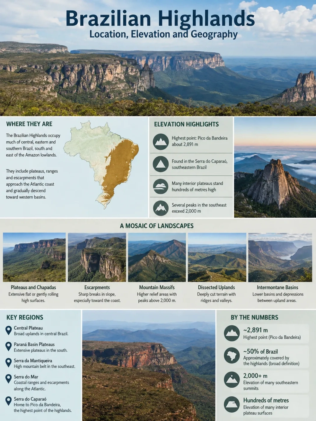
The Brazilian Highlands, also called the Brazilian Plateau or Planalto Brasileiro, form a broad belt of elevated terrain across much of central, eastern and southern Brazil. Rather than one flat tableland, the region contains rolling plateaus, deeply cut uplands, flat-topped chapadas, mountain massifs and steep escarpments near the Atlantic side of the country.
Highest point: about 2,891 m
Plateaus, ranges and escarpments
Where Are the Brazilian Highlands?
The Brazilian Highlands occupy a large part of Brazil south and east of the Amazon lowlands. Broad definitions cover roughly half of the country’s land area, although there is no single sharp boundary surrounding everything described by the term.
The highlands extend through much of central Brazil, continue across the populous Southeast and reach into the southern states. Their eastern side approaches the Atlantic coast, where elevated terrain and mountain fronts such as the Serra do Mar create strong contrasts with narrow coastal lowlands. To the west and northwest, the uplands gradually give way to lower basins, plains and depressions.
Geography Note
The Brazilian Highlands should not be read on a map as one continuous plateau with a precise edge. It is a broad physiographic name covering several distinct upland systems. Modern Brazilian geomorphology maps divide this territory into many separate plateaus, mountain regions, depressions and other relief units.
This distinction explains why maps of the Brazilian Highlands can look different. A continental-scale map may show one broad highland region, while a detailed Brazilian relief map separates places such as the Central Plateau, Paraná plateaus, Serra da Mantiqueira and numerous smaller geomorphological units.
Elevation Varies Widely Across the Highlands
There is no single elevation that represents the Brazilian Highlands. Much of the landscape stands several hundred metres above sea level, while higher plateau surfaces and mountain areas commonly reach well above 1,000 metres. A smaller number of massifs rise beyond 2,000 metres.
Pico da Bandeira
Highest highland massif
Many interior plateau surfaces
Several southeastern summits
Pico da Bandeira Is the Highest Point
Pico da Bandeira, in the Serra do Caparaó of southeastern Brazil, reaches about 2,891 metres above sea level. Brazilian geological records give a measured elevation of approximately 2,891.3 metres, while some national geographic summaries round the figure to 2,892 metres.
It is the highest summit associated with the Brazilian Highlands, but it is not the highest point in Brazil. Brazil’s highest peaks are farther north in the Serra do Imeri, within the Guiana Highlands region rather than the Brazilian Highlands.
The Highest Ground Is Concentrated in the Southeast
Several of the country’s highest upland areas occur in the southeastern mountain belts. The Serra da Mantiqueira contains peaks approaching 2,800 metres, while the Caparaó massif rises still higher. The Serra do Mar forms another elevated belt closer to the Atlantic, although its height and form change markedly along its length.
Central Brazil presents a different landscape. Instead of continuous high mountains, broad plateau surfaces, low ridges, chapadas and dissected valleys dominate much of the terrain. Elevation is high enough to influence river drainage, yet the land can appear relatively open and gently rolling over large areas.
The Highlands Are a Mosaic of Different Landscapes
Calling the region a plateau can create the impression of a vast level surface. The actual relief is much more varied. Long periods of weathering, river incision, faulting, uplift and differential erosion have produced several contrasting types of terrain.
| Area | Typical Relief | Examples | Geographic Character |
|---|---|---|---|
| Central interior | Broad plateaus, chapadas and dissected uplands | Central Plateau, Chapada dos Veadeiros | Major watershed terrain with extensive interior surfaces |
| Eastern highlands | Mountain belts, escarpments and deeply cut valleys | Serra do Mar, Serra da Mantiqueira | Strong elevation contrasts between uplands and the Atlantic side |
| East-central belt | Long ridges, rocky plateaus and elevated massifs | Serra do Espinhaço, Chapada Diamantina, Caparaó | Contains major drainage divides and some of the highest eastern terrain |
| Southern interior | Layered plateaus, escarpments and river-cut surfaces | Paraná Plateau, Serra Geral | Large areas developed over sedimentary rocks and volcanic formations |
Chapadas Form Some of the Flatter Upland Surfaces
A chapada is generally an elevated landform with a relatively broad or flat summit and steeper margins. These landforms are especially noticeable where resistant rock layers protect the top while rivers and erosion cut into the surrounding terrain.
Chapada dos Veadeiros in central Brazil and Chapada Diamantina farther east illustrate how plateau landscapes can contain flat or gently sloping uplands beside cliffs, canyons, valleys and isolated high points. They are parts of much larger relief systems rather than evidence that the entire Brazilian Highlands are flat.
The Atlantic Side Has a Steeper Edge
Near southeastern Brazil’s Atlantic margin, the transition from high ground toward the coast becomes much sharper. The Serra do Mar forms an extensive escarpment and mountain system, while the Serra da Mantiqueira rises farther inland in parts of São Paulo, Minas Gerais and Rio de Janeiro.
Faulting, vertical crustal movements and long-term erosion associated with the evolution of southeastern Brazil helped produce this stepped landscape. River erosion has continued to cut valleys into the elevated blocks and retreat portions of the escarpments.
Ancient Rocks Do Not Mean the Present Relief Has One Age
The geological foundation beneath much of the Brazilian Highlands is very old. Large areas contain Precambrian crystalline rocks belonging to the ancient South American continental platform. These rocks include granites, gneisses and other metamorphic formations that originated long before the modern Atlantic Ocean existed.
The landforms visible today are younger than many of the rocks beneath them. An old rock body can be uplifted, fractured, weathered and eroded repeatedly, producing a landscape whose present shape reflects several different episodes of geological history.
Southern Plateaus Include Vast Volcanic Rock Sequences
The southern part of the highland system has a different geological character from many crystalline uplands in the Southeast. Large areas of the Paraná Basin are covered by volcanic rocks of the Serra Geral Formation.
These rocks formed during enormous episodes of fissure volcanism in the Early Cretaceous as South America and Africa were separating and the South Atlantic was developing. Repeated lava flows spread across large areas of the Paraná Basin. Later erosion cut rivers and escarpments through the stacked volcanic and sedimentary layers, helping form the stepped plateau topography visible across parts of southern and southeastern Brazil.
Ancient crystalline terrains form much of the geological base beneath central and eastern highland areas.
Layered sedimentary rocks underlie extensive interior plateau regions and influence cliffs, slopes and drainage patterns.
Large lava sequences covered much of the Paraná Basin and became part of the southern plateau landscape.
Rivers, weathering and slope retreat dissected elevated surfaces into valleys, ridges, escarpments and isolated remnants.
The Highlands Divide Several Major River Systems
One of the clearest geographic roles of the Brazilian Highlands is their effect on drainage. Elevated surfaces in central and eastern Brazil separate rivers flowing toward very different parts of the Atlantic drainage system.
Elevated interior terrain forms broad watershed divides.
Some rivers enter the Tocantins-Araguaia system.
The São Francisco and numerous shorter rivers ultimately reach the Atlantic.
Other rivers join the Paraná system and continue toward the Río de la Plata.
The Central Plateau is especially notable as a watershed region. High ground around central Brazil separates headwaters belonging to the Tocantins-Araguaia, São Francisco and Paraná drainage systems. Small differences in elevation can therefore send nearby streams toward river networks that eventually reach the ocean thousands of kilometres apart.
Farther east, ranges such as the Espinhaço also affect drainage direction. Parts of the range separate tributaries of the São Francisco from shorter rivers flowing east toward the Atlantic. Along the southeastern escarpments, steep gradients allow rivers to cut deeply into the plateau margins.
Climate and Vegetation Change Across the Upland System
The Brazilian Highlands cover too much territory to have one climate or one natural vegetation type. Latitude, altitude, distance from the Atlantic and the position of mountain barriers all change environmental conditions from one part of the uplands to another.
Much of the central highland interior lies within the Cerrado, where savanna vegetation, grasslands, wooded formations, gallery forests and wetland corridors occur in different combinations. Plateau surfaces and river headwaters are closely interwoven across this region.
Eastern uplands overlap extensively with the Atlantic Forest biome. Mountain relief there creates large local changes in rainfall and temperature over relatively short distances. Higher areas can support vegetation and climatic conditions quite different from nearby lowlands.
Toward northeastern Brazil, uplands meet landscapes associated with the Caatinga and other transitional environments. Farther south, cooler conditions occur on elevated terrain, with Araucaria forest historically associated with parts of the southern plateaus. Frost can occur in higher and more southerly areas during the austral winter.
These contrasts are another reason the Brazilian Highlands are better understood as a collection of connected upland regions than as one uniform physical environment.
Brazilian Highlands and Guiana Highlands Are Different Regions
Brazil contains two major highland areas that can be confused because both lie within the same country. The Brazilian Highlands occupy much of the central, eastern and southern territory. The Guiana Highlands lie far to the north, around Brazil’s borders with Venezuela, Guyana and neighboring parts of northern South America.
Brazilian Highlands
- Dominant across central, eastern and southern Brazil
- Includes extensive plateaus and southeastern mountain systems
- Contains Pico da Bandeira
- Closely linked to the Paraná, São Francisco and several Atlantic drainage systems
Guiana Highlands
- Located along the far northern part of Brazil and neighboring countries
- Geographically separate from the main Brazilian highland system
- Contains Brazil’s highest mountain, Pico da Neblina
- Much of its Brazilian drainage connects with the Amazon basin
The distinction matters when comparing elevations. Pico da Bandeira is the highest point of the Brazilian Highlands, while Pico da Neblina is higher but belongs to the northern Imeri mountain region associated with the Guiana Highlands.
Why Modern Maps May Not Label One “Brazilian Highlands”
The term Brazilian Highlands remains useful for describing Brazil at continental scale. It separates the country’s great central and eastern upland mass from areas such as the Amazon lowlands, Pantanal and northern Guiana Highlands.
Detailed geomorphology requires finer divisions. Brazilian relief classification identifies individual plateaus, mountain belts, depressions, escarpments and other terrain units according to their structure and landform history. The Central Plateau, Serra da Mantiqueira, Serra do Mar, Paraná plateaus and Caparaó massif therefore have their own geographic identities even though they can all be discussed within the broader Brazilian highland region.
This is also why assigning one elevation, one geological origin or one landscape type to the entire Brazilian Highlands is misleading. The name describes a large upland domain made from many connected but different relief systems, ranging from broad interior tablelands to some of the highest mountains in eastern South America.