South-Central British Columbia
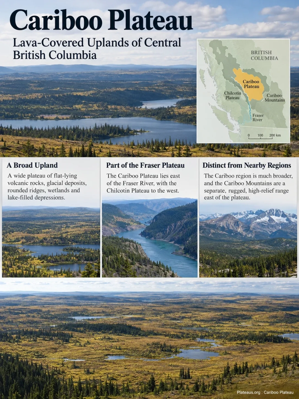
The Cariboo Plateau is a broad, rolling upland in the interior of British Columbia, forming the eastern plateau division of the Fraser Plateau. Its surface combines flat-lying volcanic rocks, thick glacial deposits, rounded ridges, lake-filled depressions, wetlands and river-cut valleys. The name is easy to confuse with the much broader Cariboo region and with the rugged Cariboo Mountains farther east, but these are different geographic units.
The Cariboo Plateau Is a Physical Landform, Not the Entire Cariboo Region
The term Cariboo is used for several overlapping parts of British Columbia, and those uses do not share one boundary. The physical Cariboo Plateau belongs to the Fraser Plateau within British Columbia’s Interior Plateau system. In broad physiographic terms, the Fraser River separates much of the eastern Cariboo Plateau from the western Chilcotin Plateau.
The historical and regional meaning of Cariboo is much broader. The Cariboo region can extend west across the Fraser and include mountains, river basins, communities and other terrain that are not part of the plateau itself. The Cariboo Mountains are another separate unit: they form rugged, high-relief mountain country east of the plateau rather than a continuation of its gently rolling surface.
Why Cariboo Boundaries Differ Between Maps
Physiographic maps classify landforms, ecological maps divide terrain by climate and ecosystems, and regional maps may follow administrative or historical usage. The Cariboo Plateau Ecosection used in British Columbia’s ecological classification is therefore not an exact substitute for every physiographic use of the name Cariboo Plateau.
| Name | What It Describes | Relationship to the Cariboo Plateau |
|---|---|---|
| Cariboo Plateau | A physical plateau within the Fraser Plateau system | The landform itself |
| Cariboo Plateau Ecosection | An ecological classification unit covering upland terrain in the southeastern Fraser Plateau Ecoregion | Overlaps the plateau concept but follows ecological boundaries |
| Cariboo region | A broader regional and historical geographic area | Extends beyond the physical plateau |
| Chilcotin Plateau | The broad plateau west of the Fraser River | A neighboring division of the Fraser Plateau |
| Cariboo Mountains | High, rugged mountain terrain east of the plateau | A different landform with much greater relief |
Chilcotin Plateau
Fraser River and its deeply dissected basin
Cariboo Plateau
Cariboo Mountains and adjoining highlands
A Rolling Plateau Rather Than a Flat Tableland
The Cariboo Plateau is broad enough to look subdued on a regional relief map, but its surface is not uniformly flat. Long upland slopes, rounded hills, low ridges, wetlands and shallow basins create a rolling landscape. Rivers and larger creeks cut much more sharply into this surface, producing local relief that can be far greater than the gentle terrain above them suggests.
Across the Central Interior plateau belt that includes the Cariboo and Chilcotin plateaus, large areas of relatively undissected upland occur around 1,200 to 1,500 metres above sea level. The upland rises toward parts of the southeast, where surfaces can approach about 1,800 metres. These figures describe a regional elevation pattern rather than one fixed elevation for the Cariboo Plateau.
This distinction matters because a plateau is defined by its broad elevated surface and relationship to surrounding terrain, not by being perfectly level. On the Cariboo Plateau, glacial deposits and stream erosion have added smaller-scale irregularities to a much broader upland surface.
Elevation Is a Range, Not a Single Number
Different mapped definitions include different parts of the upland, and the plateau surface rises and falls across a large area. A single quoted elevation can describe a locality, but it cannot accurately represent the whole landform.
Basalt Forms Much of the Plateau’s Broad Geological Foundation
Large parts of the Fraser Plateau are underlain by nearly horizontal volcanic rocks of the Chilcotin Group. Basaltic lava spread across older terrain and locally filled pre-existing lowlands, helping create extensive surfaces with relatively low regional relief.
The volcanic cover should not be imagined as one enormous lava sheet produced in a single eruption. Geological mapping in south-central British Columbia identifies several episodes of Chilcotin Group volcanism. Dated flows have been grouped into episodes around 14–16 million, 6–9 million and 1–3 million years ago in parts of the interior. Older flows tend to form broader remnants, while some younger flows occupy former valleys.
Where erosion exposes the volcanic sequence, basalt can form resistant cliffs, rimrock and locally column-jointed outcrops. Yet much of the plateau does not show bare lava at the surface because younger glacial sediments cover the bedrock.
Basalt Distribution and Plateau Boundaries Are Different Things
The Chilcotin Group extends across more than one physiographic unit. Its geological distribution should not be used as a direct boundary map for the Cariboo Plateau.
Soils, wetlands, forests and modern stream deposits
Till, glaciofluvial material and other sediments left or reworked by ice and meltwater
Flat or gently dipping basalt flows across many parts of the plateau
Older volcanic, sedimentary, metamorphic and intrusive rocks beneath or between younger volcanic units
Cordilleran Ice Reworked the Volcanic Upland
The modern surface cannot be explained by volcanism alone. During the Pleistocene, the region was overridden by the Cordilleran Ice Sheet. Ice moving across the interior rounded pre-existing hills and ridges, transported large quantities of rock and sediment, and left widespread glacial deposits over the volcanic bedrock.
This glacial cover is one reason bare basalt is less dominant in the landscape than the underlying geology might suggest. Morainal till blankets large areas. Meltwater sorted other sediments into glaciofluvial deposits, while ice movement produced streamlined forms and modified drainage routes.
Drumlins and drumlin-like ridges occur in parts of the wider Fraser Plateau, along with eskers, meltwater channels and other landforms associated with glacial flow and retreat. Low depressions were also left in terrain where water could collect after the ice disappeared.
Basalt flows helped establish broad, relatively low-relief surfaces.
Cordilleran ice crossed the plateau and modified older slopes and ridges.
Till and meltwater sediments accumulated across large areas.
Wetlands, shallow basins, lakes and modern drainage developed across the reworked surface.
The resulting landform is therefore layered in both age and process. The broad plateau owes much of its geological foundation to older volcanism, while much of the texture visible at ground level comes from glaciation and postglacial erosion.
The Fraser River Cuts Below the Plateau Surface
The Fraser River is more than a drainage route beside the Cariboo Plateau. Its deeply incised valley is one of the clearest physical breaks in the Fraser Plateau. The river and lower reaches of its tributaries descend well below surrounding uplands, creating steep valley walls and dissected terrain between the Cariboo and Chilcotin sides.
This contrast is easiest to understand as two scales of relief operating together. The upland can remain gently rolling for long distances, while a major river valley cuts deeply through the same regional surface.
Within the Cariboo Plateau Ecosection, several rivers carry water generally westward toward the Fraser system. These include the Quesnel, Horsefly and Canim rivers. Southern parts of the broader plateau drainage differ: some water reaches the Thompson River system through the upper Bonaparte drainage.
Much of the plateau drains toward the Fraser River through tributary systems descending from the uplands.
Some southern uplands drain toward the Thompson system rather than directly west to the Fraser.
The valleys also reveal geology that is hidden beneath glacial deposits on the plateau surface. Where rivers and creeks have cut downward, they may expose basalt, older bedrock and layers of unconsolidated glacial or postglacial sediment.
Glacial Depressions Help Explain the Plateau’s Many Lakes and Wetlands
Lakes are a defining part of the Cariboo Plateau landscape, but their abundance is not simply a matter of high precipitation. The shape and drainage of the glaciated surface are equally important.
Ice left an irregular blanket of sediment across the uplands. In low-gradient terrain, shallow depressions can hold water because runoff is slow and local drainage divides are subtle. Fine-grained glacial deposits can also reduce infiltration in some settings. The result is a landscape with numerous wetlands, ponds, small lakes and connecting streams.
The Cariboo Plateau Ecosection contains medium-sized lakes such as Canim, Sheridan, Deka, Bridge, Eagle and Bonaparte, together with many smaller water bodies. Schoolhouse Lake Park preserves a representative example of rolling forested Cariboo Plateau terrain containing several lakes.
These water bodies do not all share the same origin or chemistry. Some occupy glacially modified basins with normal external drainage. Others occur in more restricted basins where evaporation and groundwater chemistry produce very different conditions.
Some Cariboo Plateau Basins Produce Hypersaline Lakes
One of the more unusual features of the southern Cariboo Plateau is the presence of highly saline and alkaline lake basins. Research on Basque Lakes, Salt Lake and Last Chance Lake shows that some small interior basins can develop brines with very high concentrations of dissolved ions.
These lakes form in a setting where water chemistry, groundwater movement, limited surface outflow and evaporation interact. Groundwater acquires dissolved material while moving through soils, sediments and bedrock. When that water reaches a basin with restricted drainage, evaporation removes water but leaves dissolved salts behind.
Minerals Enter Groundwater
Water moving through rock and sediment dissolves mineral ions.
Water Collects in a Restricted Basin
Some shallow basins have little effective surface outflow.
Evaporation Removes Water
Warm-season evaporation lowers water volume while dissolved material remains.
Brine Becomes Concentrated
Repeated concentration can produce saline or hypersaline water and seasonal mineral deposits.
The studied lakes differ chemically from one another. Basque Lakes and Salt Lake contain brines in which magnesium and sulfate are prominent, while Last Chance Lake has a different major-ion balance. This variation shows why the lakes should not be treated as identical examples of a single chemical lake type.
Some of these basins also develop separate adjoining brine pools that create a spotted surface pattern during suitable seasonal conditions. The pattern reflects the unusual chemistry and internal structure of the lake beds rather than a feature shared by Cariboo Plateau lakes in general.
Most Cariboo Plateau Lakes Are Not Hypersaline
The saline basins are localized features. They are useful because they show how geology, groundwater, basin shape and evaporation can produce very different lake environments within the same broad plateau landscape.
Moisture and Elevation Create a Forest–Grassland Transition
The Cariboo Plateau does not have one uniform vegetation cover. Climate changes across the interior, and local elevation, slope direction, soils, drainage and fire history add further variation.
Lower and drier parts of the wider Cariboo landscape support open forests and grasslands, especially on warm, exposed slopes. Interior Douglas-fir is common in many lower areas. Lodgepole pine becomes widespread across cooler uplands, while white spruce and subalpine fir become more important in cooler or moister settings.
The Cariboo Plateau Ecosection is generally cooler and receives more moisture than the adjacent Cariboo Basin Ecosection. Its greater elevation and proximity to rising terrain toward the east help create this difference. Provincial ecological classification places large areas within Sub-Boreal Pine–Spruce and Sub-Boreal Spruce environments, with changes occurring across elevation and latitude.
Grassland patches, open forest and Douglas-fir are more likely on dry lower terrain and warm exposures.
Lodgepole pine, trembling aspen, wetlands and mixed forest form broad mosaics.
Spruce and subalpine fir become more common toward higher and cooler settings.
South-facing slopes can be noticeably drier than nearby shaded slopes, allowing grassland and open forest to occur close to denser tree cover. Wet depressions introduce another layer of variation, so the surface often appears as a mosaic rather than a continuous forest type.
Cariboo Plateau, Chilcotin Plateau and Cariboo Mountains Form Very Different Terrain
The surrounding landforms make the character of the Cariboo Plateau easier to identify. The Chilcotin Plateau shares several broad traits, including volcanic bedrock, glacial modification and large areas of gently rolling upland. The Cariboo Mountains, by contrast, have steep slopes, narrow valleys and high alpine relief.
| Feature | Cariboo Plateau | Chilcotin Plateau | Cariboo Mountains |
|---|---|---|---|
| Regional position | Mainly east of the Fraser River | Mainly west of the Fraser River | East of the plateau country |
| Dominant relief | Rolling upland with local river incision | Broad rolling to gently sloping plateau terrain | Steep, rugged mountain relief |
| Volcanic plateau rocks | Widespread in many areas | Widespread in many areas | Not the defining landform structure |
| Glacial imprint | Extensive till, rounded terrain, lake and wetland basins | Extensive glacial cover and streamlined landforms | Strong mountain glacial erosion and alpine forms |
| Typical visual character | Forested and locally grassland-covered uplands dotted with lakes | Open and forested plateau country with broad drainage basins | High ridges, narrow valleys and alpine terrain |
Human Land Use Follows the Plateau’s Relatively Gentle Surface
Much of the Cariboo Plateau offers gentler terrain than the mountain belts to the east. That physical difference has influenced how roads, ranches, forestry operations and communities occupy the interior.
Forestry is widespread across forested uplands, while ranching and agricultural land are concentrated where soils, climate, access and topography allow. Roads often follow the easier gradients of the plateau or use major valleys to cross more dissected terrain. Settlements such as 100 Mile House and Williams Lake belong to the wider Cariboo landscape, although regional names and physical plateau boundaries should not be assumed to match municipal or resource-management boundaries.
The same gently rolling relief that aids access also creates many wet depressions and small drainage systems. Roads, forest harvesting and other land uses therefore intersect a dense network of streams, lakes and wetlands rather than crossing a uniformly dry upland.
Fire, Beetles and Forest Harvesting Are Reshaping the Modern Landscape
The present-day Cariboo landscape continues to change after the volcanic and glacial processes that established its physical form. Large wildfires, forest insect outbreaks, timber harvesting and subsequent salvage logging have altered forest age and structure across parts of the broader region.
The mountain pine beetle outbreak affected extensive lodgepole pine forests in interior British Columbia, including Cariboo uplands. Fire has subsequently become another major source of landscape change. Provincial assessments of the wider Cariboo region also identify flooding and summer drought as important pressures on forests and watersheds.
Scale Matters When Reading Modern Disturbance Data
Many current fire, forest and watershed datasets are reported for the broader Cariboo administrative or natural-resource region rather than the physiographic Cariboo Plateau alone. Regional disturbance statistics should therefore not be presented as measurements for the entire plateau unless the mapped study area matches the landform boundary.
These disturbances create a patchwork of surviving mature forest, younger regrowth, burned stands, harvested areas, wetlands and open grassland. The result is a modern surface whose ecological pattern can change much faster than the underlying basalt, glacial deposits and major river valleys that define the plateau’s physical geography.