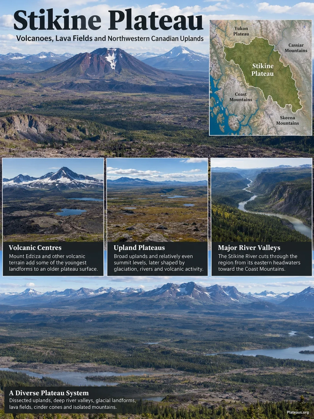
The Stikine Plateau is a broad highland system in northwestern British Columbia, but it does not look like a single flat tableland. Its older upland surfaces are broken by deep river valleys, glacial landforms, volcanic plateaus, cinder cones and isolated mountains. The Stikine River cuts through the region from its eastern headwaters toward the Coast Mountains, while volcanic centres such as Mount Edziza and Level Mountain add some of the youngest terrain to a much older physiographic surface.
A Plateau System Rather Than One Flat Surface
The name Stikine Plateau refers to a large physiographic region of the northern Canadian Cordillera. Much of it lies in the interior of northwestern British Columbia between the Coast Mountains to the west and the Cassiar Mountains to the east, with the Skeena Mountains forming a major southern boundary. To the northwest, plateau country continues toward the Yukon Plateau rather than ending at a single sharp escarpment.
A plateau is not required to be perfectly level. In the Stikine region, the more useful clue is the presence of broad uplands and relatively even summit levels that have later been cut, glaciated or covered by volcanic rocks. Some sectors remain open and gently rolling; others are deeply dissected or rise into volcanic and mountain-like masses.
Boundary Note
The Stikine Plateau is a physiographic region, not an administrative unit. Its edges follow changes in landform and relief, so the transition into neighbouring mountain or plateau regions is not equally sharp everywhere. Historical physiographic mapping also treated part of the northern boundary toward the Yukon Plateau as a conventional line rather than a natural wall.
Boundary Ranges and the Coast Mountains
Dissected uplands, volcanic terrain and major river corridors
Cassiar Mountains and adjoining highlands
The Plateau Is Divided Into Distinct Upland Units
Physiographic treatments divide the Stikine Plateau into several named subregions rather than treating the whole area as one uniform surface. A commonly used arrangement recognizes the Tahltan Highland together with the Taku, Nahlin, Kawdy, Tanzilla, Klastline and Spatsizi plateaus. Their boundaries follow major rivers, changes in relief and differences in geology.
| Unit | Position and Terrain | Distinctive Landform Character |
|---|---|---|
| Tahltan Highland | Western transition toward the Coast Mountains | More strongly dissected highland containing the Mount Edziza volcanic complex and other high volcanic terrain |
| Taku Plateau | Northwestern part of the system | Mountainous and dissected plateau country grading toward the Yukon Plateau |
| Nahlin Plateau | Between the Sheslay, Nahlin and Tuya river systems | Broad upland dominated in part by the low, wide Level Mountain volcanic edifice |
| Kawdy Plateau | Northern sector near the upper Tuya drainage | Open uplands with glacial deposits and a cluster of steep-sided glaciovolcanoes |
| Tanzilla Plateau | East of the Tuya River and north of the Stikine River | Wide valleys, rounded ridges and uplands beside the Cassiar Mountains |
| Klastline Plateau | South of the Stikine River between the Tahltan Highland and eastern plateau units | Rolling, commonly open upland cut by the Klastline, Klappan, Iskut and associated drainage systems |
| Spatsizi Plateau | Upper Stikine headwaters in the southeast | Broad open uplands and wide drift-filled valleys extending toward the Skeena, Cassiar and Omineca mountain margins |
The divisions matter because they prevent the misleading idea that one elevation, one rock type or one surface form describes the whole Stikine Plateau. The Kawdy Plateau, for example, contains classic volcano-ice landforms, while the Spatsizi Plateau is better known for broad high valleys and open uplands. The Tahltan Highland rises into the much more rugged volcanic landscape around Mount Edziza.
Three Similar Names Refer to Different Geographic Ideas
Stikine Plateau
A physiographic region: a broad system of elevated terrain defined mainly by landform, relief and drainage relationships.
Stikine Ranges
A mountain-range name associated with the Cassiar Mountains. It should not be used as another name for the plateau.
Stikinia or Stikine Terrane
A tectonostratigraphic term used by geologists for a crustal terrane. Its geological boundaries and history are different from the surface-landform boundaries of the Stikine Plateau.
Older Uplands Were Reworked by Rivers, Ice and Volcanoes
The modern landscape is easiest to understand as a surface that has been repeatedly modified. Older erosion surfaces provided broad, relatively low-relief uplands. Later uplift and river incision increased local relief. Pleistocene ice then widened valleys, moved sediment and reshaped drainage, while volcanic eruptions built fresh landforms on top of the older terrain.
Long erosion produced extensive surfaces with comparatively even summit levels.
The Stikine and its tributaries cut downward, separating upland remnants and creating deep valleys.
Cordilleran ice and mountain glaciers widened valleys, deposited drift and left streamlined terrain in several sectors.
Lava, ash, cinder cones and volcanoes formed new surfaces, especially in the Tahltan, Nahlin and Kawdy areas.
The result is a dissected plateau rather than a flat slab. Broad uplands may stand only a short distance from steep canyons, glaciated peaks or young lava fields. The relative age of these surfaces also differs: an old erosion surface can lie beside a volcanic feature formed much later.
The Stikine River Cuts Through the Upland
The Stikine River is more than the main drainage line. It is one of the landforms that most clearly reveals how much the plateau has been dissected. From headwaters on and near the Spatsizi Plateau, the river crosses the interior highlands and eventually cuts westward through the Coast Mountains toward the Pacific.
The southeastern plateau also reaches a major continental drainage divide. Parts of the Spatsizi upland drain into the Stikine system and ultimately the Pacific, while water farther east enters the Finlay River system and continues through the Peace and Mackenzie drainage toward the Arctic Ocean. This divide is another reason the Spatsizi area cannot be understood as a simple basin floor around one river.
Its best-known incision is the steep-walled canyon protected within Stikine River Park. About 80 km of canyon cuts through sedimentary and volcanic rock, and parts of the gorge reach roughly 300 m in depth. Near the Tanzilla River confluence, the active river channel is reported to narrow to roughly 2 m at one point. In physiographic descriptions, this deeply cut corridor also helps separate the Tanzilla Plateau to the north from the Klastline Plateau to the south.
Broad upland remnants remain above the river.
River incision exposes a large vertical section through volcanic and sedimentary terrain.
The river can lie hundreds of metres below nearby uplands.
This vertical separation is why a single elevation figure is a poor description of the Stikine Plateau. River floors, broad plateau surfaces and volcanic summits can differ by well over a kilometre within the same regional landform system.
Volcanoes Built New Terrain Across the Plateau
Volcanism is one of the features that makes the Stikine Plateau unusually varied. The landscape includes broad shield-like volcanoes, composite volcanic centres, basalt plateaus, lava fields, cinder cones and volcanoes formed in contact with glacial ice.
Mount Edziza Rises Above the Tahltan Highland
Mount Edziza is the dominant volcanic centre on the western side of the Stikine Plateau system. Its summit reaches 2,787 m, well above much of the surrounding upland. The volcanic complex includes extensive basalt flows as well as more silica-rich volcanic rocks, cinder fields, cones and a heavily glaciated central mountain.
Repeated eruptions built volcanic surfaces across an older plateau landscape. The complex therefore records two scales of relief at once: the regional Stikine upland beneath and around it, and a younger volcanic massif rising above that surface.
Level Mountain Spreads Broadly Across the Nahlin Plateau
Farther north, Level Mountain has a different shape. It forms a broad, low-profile volcanic mass over part of the Nahlin Plateau rather than a single steep cone. Its wide footprint can be difficult to recognize on a small-scale map because the volcanic edifice merges with the surrounding highland.
The Kawdy Area Preserves Volcano-Ice Landforms
The Kawdy and Tuya area contains more than 30 known Pleistocene glaciovolcanoes. Several were built while the Cordilleran Ice Sheet covered the region. Eruptions beneath or within ice produced steep-sided volcanic edifices and deposits that preserve evidence of meltwater lakes and former ice thickness.
What Is a Tuya?
A tuya is a steep-sided, commonly flat-topped volcano whose shape develops when lava erupts beneath thick ice. Water produced by melting ice confines early eruptions; once volcanic material grows high enough to emerge above the water or ice, lava can spread across the top. The landform name was introduced from Tuya Butte in northern British Columbia, where this style of volcano-ice interaction was first described in geological literature.
Glaciation Changed Both Relief and Drainage
Ice affected nearly every part of the Stikine highlands, but its imprint varies from one subregion to another. Broad valleys were widened and deepened, upland surfaces were smoothed in places, and thick deposits of till and meltwater sediment accumulated after ice retreat.
On the Kawdy Plateau, glacial drift includes streamlined, drumlin-like hills and shallow depressions. On the Spatsizi Plateau, wide valleys contain extensive drift and contrast with the higher open uplands. Around Mount Edziza, volcanic rocks and glacial deposits overlap in a more complicated sequence, recording eruptions before, during and after periods of ice cover.
Glaciation also altered drainage. Some river courses were diverted or reorganized as ice blocked valleys and meltwater found new routes. This history helps explain why modern drainage lines do not always follow the simplest path across the plateau surface.
Elevation Changes Sharply Across the Region
Much of the Stikine Plateau lies at high subalpine elevations, and broad areas occur around or above 1,500 m. That regional figure should be read as a terrain tendency, not as a fixed plateau height. The Spatsizi Plateau, for example, commonly occupies elevations of roughly 1,600 to 2,000 m, while deeply incised valleys lie lower and volcanic or mountain summits rise much higher.
Common elevation of broad upland terrain across much of the regional plateau
Typical range across much of the Spatsizi Plateau
Mount Edziza summit
The contrast between upland surface and valley floor is often more informative than the elevation of any one named point. It shows how strongly rivers and glaciers have cut into a region that still retains broad plateau-level surfaces.
Relief Creates Strong Climate and Habitat Contrasts
The plateau sits inland from the Pacific but close enough to the Coast Mountains for topography to shape moisture patterns. Air crossing the coastal ranges loses much of its moisture before reaching parts of the interior, while elevation keeps large areas cool. Weather can therefore shift abruptly between sheltered valleys, open uplands and exposed alpine terrain.
Vegetation follows the same relief. Lower and more sheltered valleys can support boreal forest, willow flats and wetlands. Higher surfaces become more open, with subalpine woodland, shrub communities, tundra-like vegetation and exposed alpine ground. Around the highest volcanic and mountain terrain, snowfields, glaciers and bare rock interrupt the vegetation almost completely.
Spatsizi Shows the Link Between Landform and Wildlife
The Spatsizi Plateau and its broad valleys make this relationship especially clear. Rain-shadow conditions in parts of the area can keep winter snow relatively shallow, which supports important woodland caribou habitat. The Spatsizi River valley, with wetlands, oxbow ponds and willow flats, provides a very different setting for moose. Mountain goats, grizzly bears, wolves and other northern mammals use adjoining uplands, slopes and valleys.
The pattern is not simply a list of species spread evenly across a plateau. Habitat changes with elevation, snow depth, drainage and the transition from forested valley floors to open subalpine and alpine terrain.
Edziza Is Also a Tahltan Cultural Landscape
The western Stikine highlands around Mount Edziza have a long Tahltan history. The Tahltan name Edzi’dzā’e is associated with the sound of walking on hollow lava rocks, and the volcanic landscape contains natural sources of dudāt, or obsidian.
Tahltan people have travelled onto the high plateaus around Edziza for more than 10,000 years to obtain this volcanic glass. Obsidian was worked into knives, spear and arrow points and other tools, and it was traded both as raw material and as finished objects. Quarry and working areas occur high on the volcanic massif, including terrain above 1,750 m.
Retreating ice patches have added another layer to the archaeological record. Surveys around the Edziza and Kitsu Plateau area have recovered perishable materials that normally decay, including wooden walking staffs, birch-bark fragments, hunting equipment and objects made from bone, antler and hide. Radiocarbon ages from a set of perishable finds span thousands of years, showing repeated use of high alpine terrain rather than occasional travel across an empty upland.
Why Ice-Patch Archaeology Matters Here
Obsidian survives well in open terrain, but wood, hide and bark usually do not. When such materials remain frozen at the edge of long-lived ice patches, they can preserve evidence of how people travelled, hunted and worked stone on the high plateau. Continued ice retreat also means newly exposed organic artifacts can deteriorate rapidly once they leave frozen conditions.
Protected Areas Follow the Plateau’s Physical Geography
Several large protected areas line up with the landforms that define the Stikine system. Spatsizi Plateau Wilderness Park protects upper Stikine headwaters, broad plateau terrain and adjoining mountain habitats. Stikine River Park follows the river corridor and the deep canyon through the central highlands. Mount Edziza Park protects the volcanic complex and surrounding Tahltan Highland.
Together, the river park forms a protected connection between the Spatsizi landscape to the east and Mount Edziza to the west. The arrangement mirrors the physical geography: headwater plateau, deeply incised river corridor and volcanic highland are connected as parts of one larger system rather than isolated scenic features.
Current Research Is Testing Mount Edziza’s Recent Eruptive Record
A research program permitted in 2026 is designed to examine the volcanic history of Mount Edziza over roughly the last 12,000 years. The work calls for sampling vents, cones and lava flows and comparing them with tephra layers found well beyond the volcanic complex.
Previously identified ash deposits occur along Highway 37 and as far as about 230 km east of Edziza. The permit record describes evidence for approximately 9 to 13 explosive eruptions that may be linked to Mount Edziza and the Iskut Volcanic Field. Matching those distant tephra layers to individual source vents would improve the eruption chronology and help separate activity from neighbouring volcanic centres.
The field program also includes a peat core near Raspberry Pass and Bourgeaux Creek to test reported tephra layers, along with renewed mapping of Edziza’s glaciers, which have not been mapped in comparable detail since the 1970s–80s. Retreating ice can expose volcanic surfaces that were previously hidden, so glacier change can reveal geological evidence needed to reconstruct the plateau’s youngest volcanic history.