Central British Columbia
The Nechako Plateau is a broad, glaciated upland in the northern part of British Columbia’s Interior Plateau. Its surface is usually subdued rather than table-flat: long low ridges, rounded uplands, shallow basins, lakes, wetlands and river-cut corridors sit above a geologically varied foundation of volcanic, sedimentary and intrusive rocks.
53rd Parallel to Nation River
Strongly reshaped by Pleistocene ice
Where the Nechako Plateau Sits
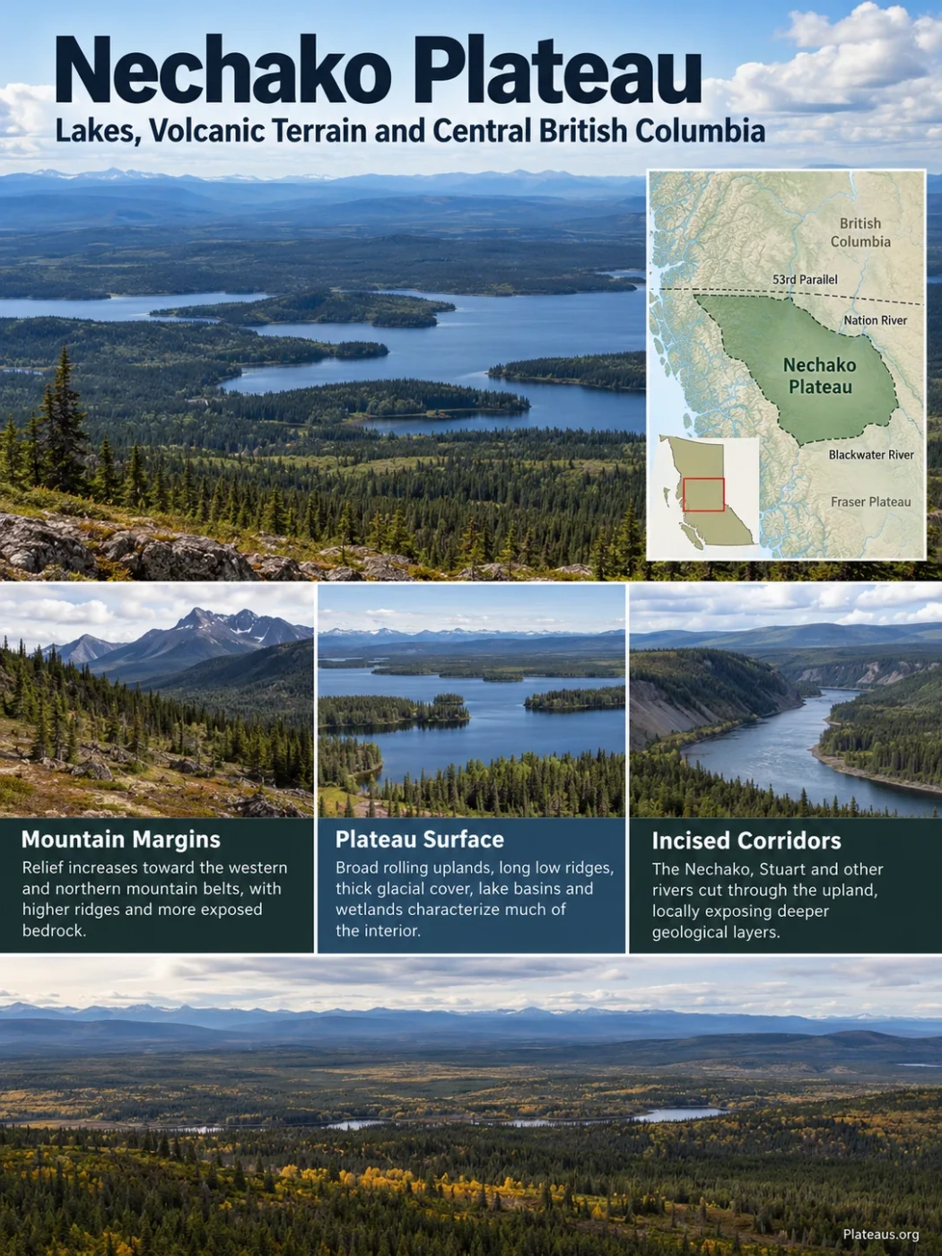
The official British Columbia geographical-name record places the Nechako Plateau from the 53rd Parallel north to the Nation River, east of the Tahtsa and Bulkley ranges. It occupies a large part of central and north-central British Columbia between mountain belts to the west and north and lower-relief interior terrain toward the east.
The southern boundary is especially useful for understanding the landform. Geological mapping treats the Blackwater River as a natural division between the Nechako Plateau to the north and the Fraser Plateau to the south. The change is not a cliff or a sharp wall. It is a physiographic transition in the character of the upland.
Geography Note
Nechako Plateau and Nechako River watershed are not the same geographic unit. The plateau is a physiographic landform. The watershed is the drainage area feeding the Nechako River and includes source areas in the Coast Mountains as well as terrain outside the plateau. Watershed area figures should therefore not be used as the plateau’s area.
A Low-Relief Plateau with Long Ridges and Broad Basins
The word plateau can suggest a flat, elevated slab, but the Nechako surface is more varied. Provincial physiographic descriptions characterize it as an area of low relief with broad expanses of flat or gently rolling ground. Compared with the lower Fraser Basin, the Nechako Plateau has more relief and is marked by long, low ridges.
Mapped parts of the plateau commonly lie around 1,200 to 1,500 metres above sea level, but that range is not a fixed elevation for the entire landform. Lower basins, river valleys and lake depressions occur below the main upland surface, while isolated hills and small ranges rise above it. In the southern plateau, mapped study areas include terrain roughly from 790 to 1,370 metres, with nearby rounded uplands standing higher.
This mix of subdued uplands and local relief gives the Nechako a different appearance from a deeply dissected plateau. Many valleys are broad, drainage can be poorly organized, and water frequently occupies shallow depressions. Elsewhere, rivers have cut through the surface and exposed rock beneath the thick cover of glacial sediment.
Relief strengthens toward the western and northern mountain belts, with higher ridges and more exposed bedrock.
Broad rolling uplands, long low ridges, thick drift cover, lake basins and wetlands dominate much of the interior surface.
Nechako, Stuart and other river systems cut through or cross the subdued upland, locally exposing deeper materials.
The Bedrock Is More Complicated Than a Single Lava Plateau
The Nechako Plateau is sometimes reduced to a flood-basalt landform. That description is too simple. Volcanic rocks are widespread, but the plateau rests on a much older and more varied geological foundation. Different parts expose Jurassic volcanic and sedimentary rocks, Cretaceous volcanic and sedimentary packages, Eocene volcanic sequences, intrusive bodies and younger basaltic cover.
In the southern plateau, rocks of the Hazelton Group form part of the older foundation. Later volcanic activity added other units, including Late Cretaceous rocks of the Kasalka Group. During the Eocene, volcanism produced the felsic Ootsa Lake rocks and the more mafic to intermediate Endako volcanic rocks. Ootsa Lake felsic volcanism in the wider region is commonly dated to roughly 53–47 million years ago.
Younger Chilcotin Group basalt occurs in parts of the region and can form broad, flat-lying lava surfaces. It should not be treated as a uniform cap over the whole Nechako Plateau. The present landform is the product of multiple rock packages, erosion, faulting, volcanism and later glacial modification rather than one continuous lava sheet.
Older Volcanic and Sedimentary Foundation
Hazelton Group rocks are exposed in parts of the plateau and form part of the older bedrock beneath younger cover.
New Volcanic and Sedimentary Packages
Kasalka volcanic rocks and related units added another layer to the southern and western geological record.
Ootsa Lake and Endako Volcanism
Felsic eruptions produced rhyolitic to dacitic rocks, while mafic to intermediate volcanism added extensive andesitic and related units.
Younger Basaltic Cover
Chilcotin Group basalt covered parts of the older terrain, especially toward the southern Interior Plateau.
Ice Reworked the Surface
Continental-scale glaciation streamlined uplands, spread till across the bedrock and reorganized drainage.
Ice Shaped Much of the Landscape Seen Today
The present Nechako surface cannot be explained from bedrock alone. During the Late Wisconsinan Fraser glaciation, roughly 25,000 to 10,000 years ago, glaciers expanded from surrounding mountain regions and merged into the Cordilleran Ice Sheet. Ice moved onto and across the plateau from the Skeena, Hazelton, Coast and Omineca mountain systems, with flow directions changing as the ice sheet grew and its divide shifted.
At maximum ice extent, an ice divide developed over the Nechako Plateau. The moving ice smoothed and streamlined the surface, while later melting left thick deposits of till, sand, gravel and lake sediment. The result is a landscape in which the shape of the ground often records ice movement more clearly than the rock below it.
Mountain Glaciers Expanded
Ice spread from surrounding mountain centres into major valleys and across the plateau margin.
Ice Streams Crossed the Upland
Coalescing glaciers formed a larger ice sheet that overrode broad areas of the low-relief surface.
The Surface Was Streamlined
Drumlins, flutings and crag-and-tail forms developed along ice-flow paths, giving many ridges an elongated shape.
Retreat Left Drift and Meltwater Landforms
Till, eskers, glaciofluvial deposits, meltwater channels and glacial-lake sediments remained after the ice withdrew.
Much of the Bedrock Is Hidden
Glacial drift covers large areas of the plateau, so exposed bedrock can be sparse. In some mapped sectors, rock is visible mainly on higher hills, lake shores, road cuts and the up-ice ends of crag-and-tail landforms. Geological work in parts of the western and central plateau has reported bedrock exposure as low as about five percent locally.
That matters when reading the landscape. A smooth hill may reflect a buried bedrock high, a thick till mantle, glacial streamlining or a combination of all three. Surface shape does not always reveal the exact rock unit underneath.
Glaciation Helps Explain the Plateau’s Many Lakes and Wetlands
The Nechako region is rich in lakes because low relief and glacial modification work together. Ice deepened or modified depressions, deposited material across older drainage routes and left an uneven mantle of sediment. After deglaciation, water collected in shallow basins while fine sediment accumulated in former glacial lakes.
Low-lying areas around parts of the Nechako River, Babine Lake and the Nechako Reservoir contain belts of glaciolacustrine sediment. Elsewhere, small depressions in drift support ponds, wetlands and short connecting streams. The drainage pattern is therefore not simply a set of rivers cut into bare rock; it is partly inherited from the way ice and meltwater rearranged the surface.
| Landscape Feature | What It Often Records |
|---|---|
| Long, streamlined ridges | Former ice-flow direction, especially where drumlin-like and fluted forms are developed |
| Broad flat lowlands | Glacial-lake sediment, valley fill or subdued till-covered terrain |
| Small lakes and wetlands | Poor drainage across irregular glacial deposits and shallow depressions |
| Eskers and gravel ridges | Sediment deposited by meltwater flowing within or beneath retreating ice |
| Sparse rock outcrop | Thick drift masking the older geological surface |
Rivers Cross a Surface That Ice Had Already Reworked
The Nechako River is the best-known drainage feature associated with the plateau, but the plateau should not be defined simply as the Nechako basin. The river rises from the western reservoir system and flows eastward across part of the Interior Plateau before joining the Fraser River at Prince George. The Stuart River joins the Nechako downstream of Vanderhoof, while the Endako system drains another part of the central plateau.
The Blackwater River has a different geographic role: besides carrying water, it marks a useful physiographic transition along the southern side of the Nechako Plateau. This is a good example of why river basins and landform regions do not always share the same boundaries.
In low-relief sectors, rivers occupy broad valleys and sediment-filled corridors. Where channels cut more deeply, they can expose volcanic bedrock and older deposits that are otherwise concealed beneath glacial material.
Nechako Canyon Exposes the Rock Beneath the Rolling Surface
Southwest of Vanderhoof, the Nechako River cut a narrow gorge through volcanic rock. The protected area includes the roughly 7-kilometre Grand Canyon of the Nechako, where steep walls, pinnacles and overhanging rock contrast sharply with the broad uplands around it.
The canyon is also unusual because its modern appearance no longer matches the river process that carved it. Construction of Kenney Dam in the early 1950s blocked the former upper Nechako outlet. Water stored in the Nechako Reservoir is managed through a diversion system, and the old canyon downstream of the dam is now largely a dry riverbed.
This makes the canyon a clear example of two different stages of landscape history in the same place: an erosional gorge cut by the former river, followed by a modern reorganization of drainage that removed the regular flow responsible for that erosion.
The Reservoir Joined Several Former Lake Basins
The Nechako Reservoir is not a natural lake with a simple shoreline. The official reservoir system incorporates Tahtsa, Ootsa, Whitesail, Knewstubb, Natalkuz and Tetachuck lakes together with connecting reaches, arms and rivers. Kenney Dam construction began in 1951, reservoir filling began in 1952 and the dam was completed in 1954.
That change is visible in the geography of the plateau. The reservoir forms a long, branching water body across pre-existing valleys and lake basins, while the former Nechako Canyon records the older outlet route.
Water left the upper lake system through the natural Nechako outlet and canyon.
The dam impounded the upper system and connected several existing lake basins into the managed reservoir.
Much of the stored water is diverted west for hydroelectric generation, while regulated water reaches the Nechako system through the Cheslatta route rather than the old canyon.
Forest Patterns Follow the Plateau’s Relief, Moisture and Glacial Soils
Large parts of the Nechako uplands lie within the Sub-Boreal Spruce ecological zone, a landscape of cold winters, warm summers, spruce-dominated mature forests, extensive lodgepole pine stands and numerous lakes and wetlands. The broad, gently rolling topography of the Interior Plateau is one of the main settings for this forest zone.
At the southernmost edge of the Nechako Plateau, the drier Sub-Boreal Pine–Spruce zone appears on high, gently rolling terrain. Lodgepole pine is especially common there, with wetlands scattered through the forested upland. Higher or wetter local terrain can support different mixtures, including hybrid white spruce, subalpine fir and other interior forest communities.
The forest pattern reflects more than latitude. Elevation, distance from the Coast Mountains, local moisture, drainage and the texture of glacial deposits all affect what grows on a particular part of the plateau. Fine lake-bottom sediments, coarse meltwater gravels and compact till can produce very different soil-water conditions even where elevations are similar.
Nechako Plateau, Watershed and Reservoir Describe Different Things
The repeated use of the name Nechako for several geographic features can create misleading measurements and boundaries. The distinction is easiest to see when each term is tied to the process that defines it.
| Term | What Defines It | Why It Should Not Be Substituted for the Plateau |
|---|---|---|
| Nechako Plateau | A physiographic upland of the Interior Plateau, officially described from the 53rd Parallel to the Nation River east of the Tahtsa and Bulkley ranges | Its limits follow landform geography rather than the direction in which every stream drains |
| Nechako River Watershed | The land draining to the Nechako River and its tributaries; the basin exceeds 47,200 km² when the Stuart system is included | It reaches into mountain source areas and therefore crosses physiographic boundaries |
| Nechako Reservoir | A managed water body behind Kenney Dam that joins six named lake basins and connecting reaches | It is a modern hydrologic feature occupying only part of the wider plateau region |
| Nechako River | A river flowing east across part of the Interior Plateau to the Fraser River | A river corridor does not define the full extent of the upland around it |
Measurement Caution
A single definitive area for the Nechako Plateau should not be inferred from watershed, reservoir, regional-district or ecological-zone statistics. Those boundaries are drawn for different purposes and do not coincide.