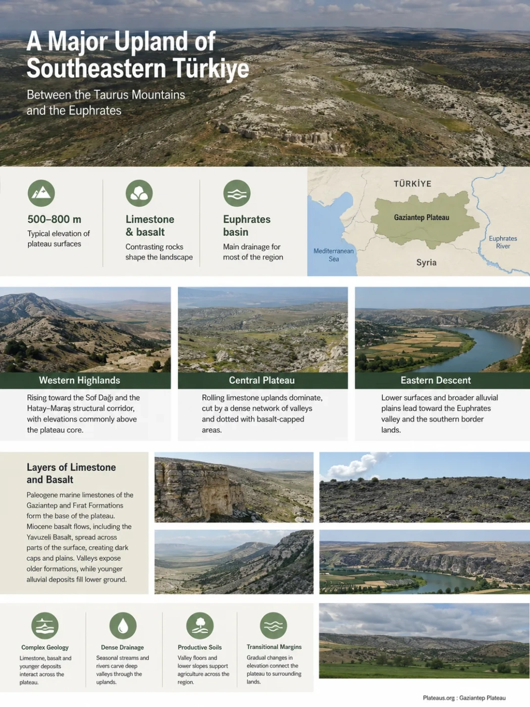
The Gaziantep Plateau is a broad, dissected upland in southeastern Türkiye where pale limestone surfaces, local basalt flows, embedded plains and river-cut valleys meet between the southern Taurus margin and the Euphrates. Much of the plateau lies around 500–800 m above sea level, but the land steps downward toward the south and east, while streams have carved a dense network of valleys across what is far from a uniformly flat surface.
Common elevation range of the broader plateau surfaces
Contrasting rocks that shape much of the upland
Main drainage destination across most of the region
A Regional Upland Between the Taurus Margin and the Euphrates
The Gaziantep Plateau occupies the western part of southeastern Anatolia, south of the outer Taurus ranges and west of the Euphrates. In broad physical-geography descriptions, the plateau extends between the Hatay–Maraş structural corridor in the west and the Euphrates valley in the east. Its southwestern continuation reaches the Kilis area near the Türkiye–Syria border.
This makes the plateau larger than the administrative province of Gaziantep. Gaziantep Province covers much of its central and eastern terrain, but the landform continues beyond provincial boundaries. Kilis, for example, lies on the plateau’s southwestern sector rather than on a completely separate upland system.
Landform Boundary
The Gaziantep Plateau is a physical region rather than an administrative unit. Its margins are transitional, so a provincial boundary should not be treated as the exact edge of the plateau.
The western and northwestern margins rise toward higher ground associated with the Sof and neighboring mountain systems. Sof Dağı reaches about 1,496 m, standing well above the more typical plateau surface. Eastward and southeastward, the relief generally becomes lower as the landscape approaches the Euphrates and the lower plains near Nizip, Karkamış and the Syrian border.
Higher, rougher ground near the Sof mountain belt and the Hatay–Maraş structural corridor
Rolling limestone-dominated uplands cut by shallow and locally deep valleys
Lower surfaces, broader alluvial areas and stronger connection to the Euphrates valley
Limestone Forms the Geological Base, but Basalt Breaks the Pattern
Limestone is central to the appearance of the Gaziantep Plateau, but describing the entire region as a single limestone tableland would hide much of its geological complexity. The plateau exposes several sedimentary formations as well as younger volcanic rocks and valley-floor deposits.
The Gaziantep and Fırat Formations
The Gaziantep Formation contains widespread white to cream-colored limestone, including clay-rich, chalky, fossiliferous and algal beds with local marl and chert. These rocks were deposited during the later Paleogene when marine environments still covered parts of the regional platform.
Above or laterally associated with these rocks in many areas is the Fırat Formation, dominated by thicker limestone beds that can include fossil-rich and reefal carbonate facies. These two carbonate units explain why pale limestone is so prominent around Gaziantep, Nizip and parts of the Euphrates margin.
Miocene Basalt Across Older Carbonate Terrain
The limestone surface is interrupted by dark volcanic rocks. Basaltic volcanism during the Miocene spread lava across parts of the Gaziantep region, especially toward Yavuzeli, the northern plateau and the Kilis sector. The unit commonly known as the Yavuzeli Basalt consists mainly of dark gray to black basaltic lava, locally accompanied by volcanic fragmental material.
The result is a landscape in which an older carbonate foundation may sit beside, beneath or beyond much younger volcanic surfaces. Later erosion cut into both rock types and exposed their boundaries.
| Geological Element | Typical Material | Landscape Expression |
|---|---|---|
| Gaziantep Formation | Clayey, chalky and fossiliferous limestone with local marl and chert | Rolling pale uplands, exposed limestone slopes and locally karstified surfaces |
| Fırat Formation | Thicker-bedded fossiliferous and locally reefal limestone | Resistant limestone ridges, valley walls and elevated surfaces |
| Yavuzeli and related basalts | Dark basaltic lava and local volcanic deposits | Dark rocky uplands, lava-covered surfaces and locally resistant caps |
| Quaternary deposits | Gravel, sand, silt and mud | Valley floors, stream corridors, floodplains and alluvial plains |
Why the Plateau Is Rolling and Dissected Rather Than Table-Flat
The Gaziantep Plateau is broad and elevated, but its surface rarely resembles a perfectly level table. Rivers and seasonal streams have repeatedly cut into the upland, creating a dissected plateau of low ridges, shallow depressions, dry valleys and deeper stream corridors.
Many regional descriptions place the main Gaziantep and neighboring Şanlıurfa plateau surfaces at roughly 500–800 m. In the southern parts of the Gaziantep Plateau, elevations can fall toward about 300 m. The difference is not simply a change from “high plateau” to “low plain.” It is a gradual regional descent interrupted by mountain blocks, basalt-covered uplands, tectonic depressions and alluvial floors.
This varying relief also explains why large named plains can occur inside a plateau region. Araban, Yavuzeli, Oğuzeli and other low areas are embedded within or along the dissected upland system rather than proving that the surrounding plateau disappears.
Plateau Surface
- Broad elevated terrain
- Commonly limestone or basalt bedrock
- Thin or stony soils in many exposed areas
- Low ridges and interfluves between valleys
Valley or Basin Floor
- Lower local relief
- Greater accumulation of alluvium and colluvium
- Deeper sediment cover in many locations
- Gentler slopes and broader agricultural surfaces
Few Permanent Streams, but a Dense Network of Valleys
One of the most revealing features of the Gaziantep Plateau is the contrast between its limited number of permanent streams and its extensive network of stream-cut valleys. Low summer rainfall, high temperatures and strong evaporation reduce perennial flow, yet runoff during wetter months has produced many channels and dry valleys across the plateau.
Some valleys carry much more water during winter and spring, then shrink sharply during the long dry season. Others are normally dry and respond mainly to rainfall events. The resulting drainage pattern can therefore be much denser on a topographic map than the number of continuously flowing streams would suggest.
The Euphrates Organizes Most of the Drainage
Most of the central and eastern plateau drains toward the Euphrates River. The river forms the dominant regional trunk system and establishes a much lower erosion level along the eastern side of the upland. Tributaries descending toward it have progressively cut into the plateau surface.
| River or Stream | Main Area Drained | Landscape Role |
|---|---|---|
| Euphrates | Eastern margin of the plateau | Regional trunk river and the main base level for eastern drainage |
| Sacır / Sajur | Central and southern plateau | Carries drainage southeastward toward the Euphrates system |
| Nizip Stream | Lower eastern plateau around Nizip | Combines channel erosion with broad meandering and alluvial deposition |
| Merzimen Stream | Yavuzeli sector | Drains dissected uplands toward the Euphrates |
| Karasu | Araban Plain and northern plateau sector | Crosses a lower basin between surrounding uplands |
| Afrin system | Western and southwestern uplands | Shows that not all plateau drainage belongs to the Euphrates basin |
Regional hydrological planning records describe Karasu in the Araban Plain as about 64 km long, while the Nizip Stream system exceeds 100 km when its branches are included. Sacır and its tributaries extend for roughly 80 km within Gaziantep Province. These figures describe drainage systems rather than uninterrupted perennial channels.
A Real Watershed Divide
The Gaziantep Plateau does not drain in only one direction. Most of its central and eastern terrain belongs to the Euphrates basin, while western sectors send water toward the Afrin–Orontes system or the Ceyhan basin. Parts of the southern and southwestern terrain drain toward closed or cross-border basins.
Nizip Shows How a Plateau Valley Changes as the Gradient Falls
The Nizip area provides a clear example of how erosion and deposition can operate within the same plateau drainage system. The eastern plateau is lower than much of the central upland, and the channel gradient decreases as streams approach broader lowland surfaces near the Euphrates.
Where the gradient becomes gentler, the Nizip Stream develops meanders rather than remaining confined to a narrow, steep channel. Sediment carried from upstream is deposited along bends and valley margins, creating broader alluvial surfaces. Extensive alluvium occurs around parts of Nizip and continues toward the Euphrates–Birecik corridor.
Runoff enters valleys cut into limestone and other bedrock.
The stream loses some of its ability to transport coarse sediment.
Lateral erosion becomes more visible as bends migrate across the lower valley.
Sand, silt, gravel and finer material accumulate beside and beyond the active channel.
The eastern edge of the Gaziantep Plateau is therefore not simply a sharp drop into the Euphrates. In places, it is a transition through lower plateau remnants, tributary valleys, alluvial surfaces and the deeply established Euphrates corridor.
The Southwestern Plateau Becomes More Volcanic Around Kilis
The southwestern continuation around Kilis demonstrates why the Gaziantep Plateau should not be interpreted as a uniform limestone landform. Official regional descriptions place Kilis on the southwestern part of the plateau between the Hatay–Maraş corridor and the Euphrates region.
Here, extensive basalt plateaus appear alongside older erosion surfaces and sedimentary rocks. Some basalt-covered uplands are gently rolling, while others are deeply cut by the Afrin drainage and its tributaries. The contrast between resistant lava surfaces and incised valleys can produce much sharper local relief than the central plateau’s broader rolling terrain.
Kilis Plain adds another element. It is a lower tectonic and depositional area bordered by plateau surfaces, while basaltic thresholds separate or interrupt some neighboring plains. This creates a mosaic of raised volcanic uplands, limestone surfaces, tectonic lowlands and stream valleys within the wider plateau region.
Sof and related mountain blocks rise above the plateau margin.
Miocene lava locally covers older sedimentary terrain.
Tectonic and depositional plains lie between raised plateau sectors.
Is the Gaziantep Plateau a Karst Plateau?
Limestone is widespread enough for dissolution and karstification to matter, but the label karst plateau needs qualification. Parts of southeastern Anatolia contain karstic features developed in carbonate rock, and some limestone units of the Gaziantep Formation show cavities and solution-related groundwater features.
Karst development is not equally strong through every limestone bed. Clay content, fractures, bedding, groundwater movement and river incision all influence how readily carbonate rock dissolves. Research on the regional carbonate sequence indicates that some upper limestone layers are more favorable for karstification than more clay-rich sections beneath them.
The plateau as a whole also contains basalt, marl, alluvium, ophiolitic rocks and tectonic lowlands. Its present relief reflects river dissection and structural deformation as well as carbonate dissolution. It is therefore more accurate to describe Gaziantep as a limestone-rich, locally karstified and strongly dissected plateau region than to imply that classic karst topography dominates everywhere.
Limestone Does Not Automatically Mean Karst Plateau
Karst is a process and landscape expression produced by dissolution of soluble rock. A plateau can contain large areas of limestone without displaying the dense sinkhole, closed-depression and cave systems associated with strongly developed karst terrain across its entire surface.
How the Present Landscape Developed
The plateau’s modern form records several different geological processes rather than one single episode of uplift or erosion. A simplified sequence helps explain why limestone, basalt and river valleys now occur together.
Carbonate Sediments Accumulated
Marine environments deposited thick carbonate sequences that later became the limestone units now exposed across much of the region.
The Regional Platform Emerged and Deformed
Uplift, folding and fault-related deformation changed the position and relief of the sedimentary surface as southeastern Anatolia evolved along the northern Arabian Plate margin.
Basalt Covered Parts of the Older Surface
Miocene volcanism produced lava flows around areas including Yavuzeli and Kilis, placing resistant volcanic rock over or beside older sedimentary formations.
Streams Dissected the Upland
River incision cut valleys through the raised terrain, exposed different rock units and divided broader surfaces into ridges and interfluves.
Alluvium Collected in Lower Valleys
Sediment accumulated where gradients weakened, producing floodplains, valley-floor deposits and broader lowland surfaces such as those around Nizip.
Climate Helps Explain the Dry Valleys and Seasonal Runoff
The plateau lies in a climatic transition zone between Mediterranean influences to the west and the drier continental conditions of southeastern Anatolia. Summers are hot and very dry, while most precipitation falls from late autumn through spring. This seasonal imbalance has a direct effect on the drainage network.
Long-term measurements at Gaziantep illustrate the contrast. Mean temperature rises from about 3.2°C in January to 28.1°C in July. Average monthly precipitation is about 102.6 mm in January but only 6.9 mm in July and 5.4 mm in August. These station values should not be treated as uniform conditions across every elevation and valley, but they show the strong seasonality affecting the plateau.
During the wetter months, runoff can reactivate channels and transport sediment from exposed slopes toward lower valleys. During summer, many smaller channels carry little or no water. High evaporation strengthens this contrast, helping produce the characteristic combination of dry uplands, seasonal valleys and relatively narrow zones of deeper alluvial soil along drainage corridors.
The same topographic differences influence land use. Stony limestone and basalt surfaces tend to support dry farming and drought-tolerant crops where soils permit, while deeper alluvial and colluvial deposits in plains and valley floors provide different soil and moisture conditions. The agricultural pattern therefore follows the underlying plateau relief rather than spreading evenly across it.