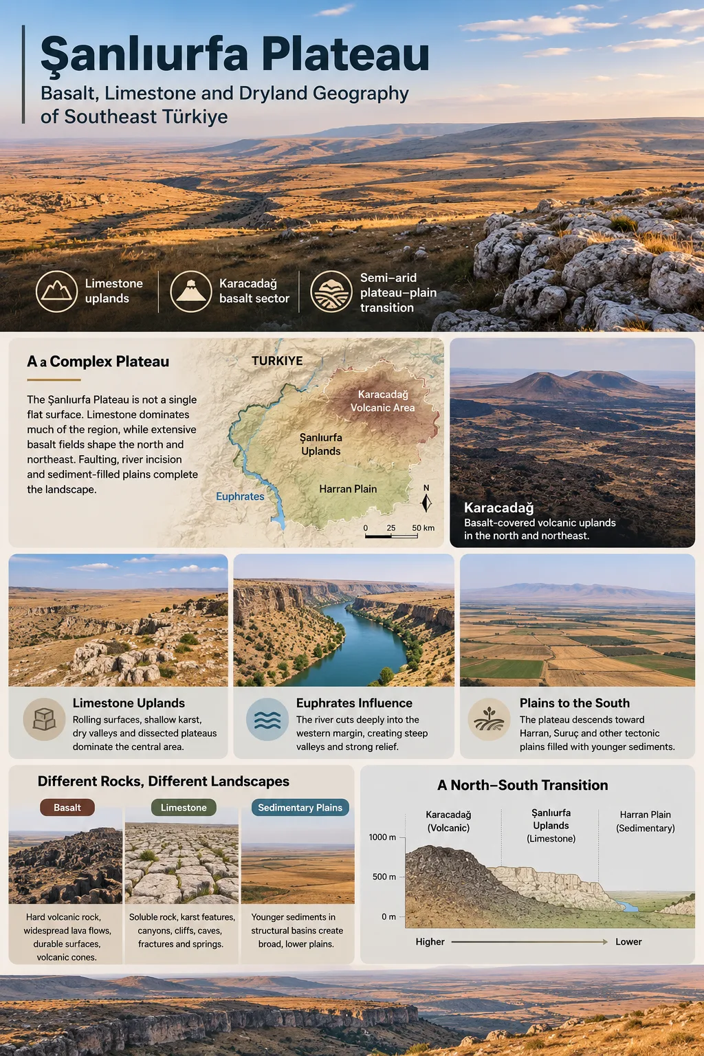
The Şanlıurfa Plateau is a broad semi-arid upland in southeastern Türkiye where pale limestone tablelands meet the dark lava fields of the Karacadağ volcanic system. Its geography cannot be explained by elevation alone: limestone and basalt create different surfaces, the Euphrates cuts deeply into the western side, and fault-bounded depressions such as the Harran Plain interrupt the plateau toward the Mesopotamian lowlands.
Karacadağ basalt sector
Semi-arid plateau–plain transition
A Plateau Made of More Than One Surface
Much of the Şanlıurfa region belongs to a rolling plateau landscape on the northern part of the Arabian Platform. Broad surfaces are developed mainly on limestone and marl, but this sedimentary terrain is interrupted in the north and northeast by extensive basalt associated with the Karacadağ volcanic complex. Farther south, the upland gives way to lower tectonic plains filled with younger sediments.
This combination makes the Şanlıurfa Plateau a poor fit for a simple label such as limestone plateau or volcanic plateau. Limestone dominates much of the regional surface, while volcanic rocks control a large and visually distinct sector around Siverek and Viranşehir. Faulting, river incision and deposition add another layer to the landscape.
Elevation and Boundary Note
Gazetteers may attach an elevation of about 420 m to the named geographic feature “Şanlıurfa Plateau.” That value represents a mapped point, not the average elevation of the entire regional plateau. Geomorphological studies describe the broader plateau surface as varying roughly from 400 to 1,000 m, excluding the much higher Karacadağ volcanic massif. There is also no single universally mapped line enclosing every plateau sector.
The regional slope generally decreases toward the south. Higher uplands and the Karacadağ sector occupy the north and northeast, while lower terrain opens toward Harran, Suruç and the plains continuing toward Syria. The result is less a single flat tableland than a connected system of elevated surfaces separated and bordered by valleys, volcanic fields and structural basins.
From Karacadağ to the Mesopotamian Lowlands
The clearest way to understand the plateau is to follow its north-to-south change in landform. Karacadağ and the basalt-covered Siverek sector occupy the higher volcanic side of the region. Central and southern uplands around Şanlıurfa are dominated more strongly by limestone. These raised surfaces then descend toward broad plains developed within tectonic depressions.
Karacadağ and the basalt-covered Siverek–Viranşehir uplands form the main volcanic sector.
Limestone and marl support rolling uplands, shallow karst, dry valleys and dissected plateau surfaces.
The plateau margins descend toward Harran, Suruç and other lower sediment-filled plains.
The Euphrates forms another major geographic control to the west and northwest. Instead of simply crossing a flat upland, the river and its tributaries have cut into the plateau margin, creating steep-sided valleys and locally strong relief. This incision is one reason the western Şanlıurfa landscape can appear much more rugged than the broad plateau surfaces farther from the river.
Geologically, this setting belongs more closely to the northern Arabian Platform and the uplands of Upper Mesopotamia than to the high interior basins of the Central Anatolian Plateau. The two regions are both called plateaus, but their bedrock, elevation pattern, climate and tectonic setting are different.
Why Basalt and Limestone Produce Different Landscapes
The strongest physical contrast within the Şanlıurfa Plateau comes from the behavior of its two major rock environments. Basalt records repeated lava emplacement. Limestone records deposition, uplift, fracturing, dissolution and erosion. The neighboring Harran Plain represents a third environment: a structural lowland where sediments accumulated between plateau margins.
| Feature | Basalt Upland | Limestone Plateau | Graben Plain |
|---|---|---|---|
| Representative areas | Siverek–Viranşehir and Karacadağ margins | Fatik, Germuş, Tektek and central Şanlıurfa uplands | Harran and related lower basin floors |
| Main surface material | Basaltic lava | Limestone, marly limestone and marl | Alluvial, colluvial and basin sediments |
| Typical appearance | Dark, rocky and locally blocky | Pale, rolling, fractured and locally karstic | Broad, smoother and lower-relief |
| Water movement | Controlled partly by fractures, lava structure and seasonal channels | Strong infiltration through joints and karst openings; many seasonal surface channels | Drainage across sediment-filled lowland, strongly modified in irrigated areas |
| Soil pattern | Highly variable; locally thin and stony | Often shallow and calcareous, with deeper pockets in depressions | Generally deeper sediment-derived soils |
Karacadağ Lava and the Siverek–Viranşehir Plateau
The northeastern part of the Şanlıurfa landscape changes abruptly where dark volcanic rocks replace the pale carbonate bedrock. These lavas belong to the Karacadağ Volcanic Complex, a large shield-volcanic system extending across southeastern Türkiye.
Karacadağ did not form in one short eruptive episode. Geochronological studies show a long volcanic history extending from the Miocene into the Quaternary. The older Siverek-phase lavas produced extensive plateau basalts before later volcanic stages built more of the Karacadağ massif and added younger flows.
This distinction matters because the Siverek–Viranşehir Plateau is not simply the summit area of Karacadağ. Much of it is an extensive lava-covered upland extending away from the main volcanic edifice. The broad distribution of fluid basaltic lava helped create surfaces very different from the sharper relief expected from a typical steep-sided volcano.
Lava Can Turn Old Low Ground Into New High Ground
One of the more unusual features of the basaltic sector is local inverted relief. Fluid lava once followed the existing slope and could enter low areas, including depressions developed in the older carbonate terrain. After the lava solidified, surrounding limestone and other softer material continued to weather and erode.
Because basalt can resist erosion differently from the surrounding carbonate rocks, some lava-filled former depressions eventually remained higher than adjacent terrain. A surface that began as low ground can therefore become a resistant ridge or elevated remnant after long erosion.
Basalt in the Field
Near Siverek, the Kördis basalt contains well-developed columnar cooling structures. These polygonal to prismatic columns formed as a cooling lava body contracted and fractured. They provide a clear field example of the volcanic processes responsible for part of the plateau’s bedrock rather than being a separate landform unrelated to the regional plateau.
Not every basalt surface has columnar jointing, and not every lava-covered area is equally rocky. Weathering, soil development, lava age, fracture density and later erosion all influence the present surface. Some areas support cultivated fields, while others remain visibly stony.
The Limestone Uplands Around Şanlıurfa
Beyond the basalt sector, pale carbonate rocks dominate much of the plateau. Nearly horizontal to gently deformed limestone and marl formations create broad, rolling surfaces rather than continuous mountain relief. Fractures, dissolution and stream incision then break these surfaces into smaller plateaus, ridges, depressions and valleys.
The Fatik, Germuş and Tektek uplands are especially useful for understanding this part of the region because they surround the northern end and sides of the Harran depression.
Western Harran Margin
Fatik Plateau
Limestone of the Fırat Formation forms dissected upland west of the Harran Plain. Valleys cut into the plateau, while fractures and soluble carbonate rock support caves and shallow karst features.
Northern Harran Margin
Germuş Plateau
The Germuş uplands form part of the raised limestone terrain north of the plain. Their position helps show the elevation break between the plateau surface and the lower Akçakale–Harran depression.
Eastern Harran Margin
Tektek Plateau
Tektek is a dry, low limestone upland between the Harran and Ceylanpınar sides of the region. Fractured Neogene limestone, shallow soils and karstic features distinguish it from the sediment-filled plains nearby.
Karst Is Present, but It Is Not Uniform
Limestone commonly encourages karst because slightly acidic water dissolves carbonate rock along joints and bedding planes. Around Şanlıurfa this process has produced dolines, shallow depressions, caves, solution features and dry or partly karst-controlled valleys. The landscape, however, should not be imagined as a continuous field of large sinkholes.
Local stratigraphy can limit how deeply karst develops. In parts of the Fatik Plateau, relatively pure and well-fractured limestone lies above more clay-rich, less permeable layers. Water can move through the upper limestone but encounter a hydraulic barrier below it. This favors shallow karst and cave development at particular levels rather than unrestricted vertical drainage through the entire rock sequence.
Karst Does Not Mean One Surface Type
The amount of visible karst depends on limestone purity, fracture patterns, impermeable layers, valley base level, soil cover and erosion. Two nearby limestone sectors can therefore show very different numbers of caves, dolines or exposed solution surfaces.
Harran Is a Graben Floor, Not Part of the Plateau Surface
The broad Harran Plain south of Şanlıurfa can look like the flattest part of the regional landscape, but geomorphologically it is not simply a continuation of the plateau. It occupies the floor of the north–south-trending Akçakale–Harran graben, a tectonic depression bordered by higher limestone terrain.
Fatik lies along the western side, Tektek along the eastern side, and Germuş forms part of the higher ground to the north. Fault-controlled relief is more obvious in the northern part of the depression. Toward the south, the bounding slopes become less pronounced and the plain opens gradually toward the lower terrain beyond Türkiye’s southern border.
The floor of the Harran Plain generally lies around 350–500 m above sea level. Material carried down from neighboring plateau surfaces has accumulated within the depression, producing a thick sedimentary lowland very different from the thin-soiled limestone above it.
Plateau–Plain Distinction
A broad flat surface is not automatically a plateau. Harran is lower than the surrounding Fatik, Germuş and Tektek uplands and occupies a subsiding, sediment-filled structural basin. Its flatness comes largely from deposition on a graben floor rather than from being the upper surface of the Şanlıurfa Plateau.
This tectonic history also affected nearby valleys. As the graben floor subsided, streams descending from the plateau margins gained relief and cut more deeply into the uplands, especially toward the northern end of the plain. Farther south, both the fault scarps and the incised valleys become less distinct.
Why the Plateau Surface Is So Dry
Şanlıurfa’s dryland character results from more than low annual rainfall. Rain is strongly concentrated in the cool part of the year, while the hottest months receive very little. At the same time, fractured limestone and basalt allow part of the available water to move below the surface rather than remain in permanent streams.
mean annual precipitation at Şanlıurfa, 1991–2020
mean January precipitation
mean July precipitation
The seasonal contrast is sharp. The official 1991–2020 climate normals give a July mean temperature of 32.6°C and an average July maximum of 39.5°C, just as precipitation falls close to its annual minimum. January, by comparison, receives about forty times as much precipitation as July.
Most useful precipitation arrives from late autumn through spring.
Rainfall becomes scarce while temperature and evaporation demand rise sharply.
Water entering limestone joints, karst openings and volcanic fractures can move below the surface.
Many channels carry water mainly after wet periods or heavy rainfall rather than throughout the year.
The combination explains why the plateau can appear intensely dry even though its limestone contains groundwater. Surface dryness and subsurface water storage are not opposites. Fractured and karstified limestone can transmit and store groundwater while the land above remains nearly streamless through much of summer.
Dry Valleys, Karst Drainage and Hidden Water
Many valleys crossing the plateau have strongly seasonal flow. During prolonged dry weather their channels may contain little or no surface water, yet they still record the work of runoff generated during wetter periods and intense storms.
In limestone terrain, some precipitation disappears into joints and solution openings before it can build a continuous surface drainage network. Elsewhere, water follows valleys until it reaches permeable rock or sinks underground. The exact pattern depends on rock structure, soil thickness, local relief and the depth of less permeable layers.
The Şeyh Müslüm cave area west of Şanlıurfa provides a useful example. There, streams have incised the Fatik Plateau while caves developed within fractured limestone near levels influenced by less permeable beds. Shallow karst depressions and valley-related solution forms occur on the surface, showing how fluvial erosion and karst can operate together rather than as separate processes.
Groundwater evidence reinforces the same point. South and southeast of Şanlıurfa, fractured and karstic limestone units function as aquifers. Water can circulate through joints, cavities and fault-controlled pathways even where the plateau itself has few permanent surface streams.
The Euphrates Cuts Across the Plateau Margin
The Euphrates provides the strongest permanent river incision associated with the western side of the Şanlıurfa uplands. Between the higher terrain north of Birecik and the lower plains farther south, the river has cut through resistant sedimentary rocks and created steep valley sides, entrenched bends and locally canyon-like relief.
Tributaries feeding the Euphrates have also dissected the plateau edge. This creates a marked contrast between broad interfluves on the upland surface and deep valleys only a short distance away. A plateau therefore does not need an unbroken flat top: river incision can leave a broad regional upland divided into ridges, valleys and smaller remnants.
Takoran Valley near Siverek lies within this dissected landscape. Its steep relief occurs close to Karacadağ volcanic rocks and the Euphrates drainage system, bringing volcanic surfaces, older bedrock and river incision into the same part of the plateau margin.
Modern reservoirs on the Euphrates have raised water levels along several valley reaches, so the present shoreline does not always show the original pre-dam depth or shape of river incision. The surrounding slopes still preserve the larger geomorphic relationship between the river and the elevated terrain.
Rock Type Controls Soil Patterns Across Short Distances
The difference between basalt, limestone and basin sediments continues upward into the soil cover. Rock type does not determine soil fertility by itself, but it influences how quickly soil forms, how deep it can become and how much stone remains at the surface.
Basaltic Ground
Basalt can weather into mineral-rich material, but a lava field is not automatically deep, fertile farmland. Stony surfaces, resistant blocks, erosion and the age of the flow can leave soil thin or discontinuous. Other basalt areas develop deeper weathered material and support cultivation. This variability is visible across the Siverek sector.
Limestone Ground
Many limestone uplands have shallow, calcareous and stone-rich soils. Dissolution can also create local pockets where fine material accumulates in depressions, fractures and valley floors. Soil depth may therefore change sharply over short distances even where the underlying bedrock remains limestone.
Plain Sediments
The Harran basin has a different soil architecture because sediment accumulated on a low-gradient structural floor. Alluvial and colluvial deposits can produce much deeper agricultural soils than those on surrounding rocky plateaus. This difference helps explain the sharp land-use boundary between the plain and its limestone margins.
Dry Farming on the Uplands, Irrigation on the Plains
Natural landform differences strongly influence agricultural geography. On the plateau, rainfall seasonality, shallow soil and exposed bedrock favor dryland cultivation, grazing and fields concentrated where soils are deep enough to work. Basaltic terrain may alternate between cultivated patches and very stony ground, while limestone uplands contain their own mosaic of shallow soils and deeper pockets.
The Harran Plain follows a different pattern. Its flatter surface, deeper soils and large irrigation networks support intensive cultivation that can appear far greener than the adjoining plateau. This visual contrast should not be interpreted as a sudden natural change to a wetter climate. Much of the difference comes from topography, sediment depth and water management.
Irrigation has also changed the hydrology of the Harran basin itself. Water that was once scarce at the surface is now redistributed across cultivated land, while drainage systems remove excess water from parts of the plain. The modern agricultural landscape is therefore partly engineered, whereas the dry limestone and basalt uplands still display the region’s semi-arid physical setting more directly.
Across Şanlıurfa, the transition can occur within a relatively short distance: dark lava and stony basalt fields in the volcanic sector, pale fractured limestone across much of the plateau, and deeper sediment-filled agricultural land on the graben floors below.