Northeastern California Volcanic Province
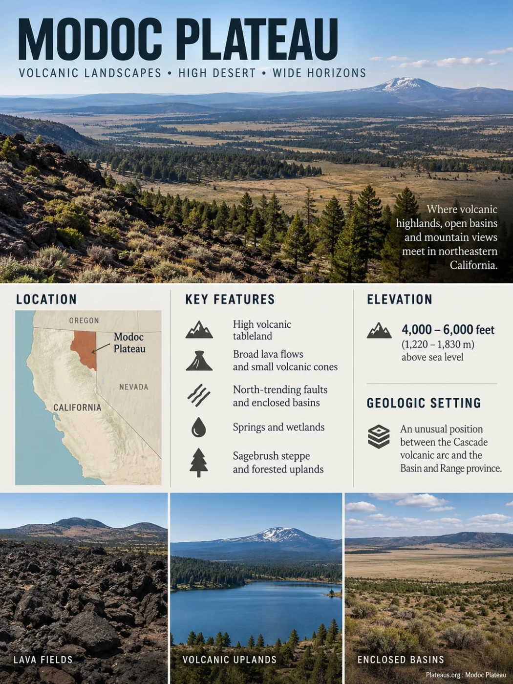
The Modoc Plateau is a high volcanic tableland in northeastern California where broad lava surfaces, small volcanic cones, north-trending faults, enclosed basins, springs, sagebrush steppe and forested uplands meet. Its geography reflects an unusual tectonic position between the Cascade volcanic arc and the Basin and Range province, so the landscape cannot be explained by volcanism alone.
Where the Modoc Plateau Fits in California
The Modoc Plateau occupies the northeastern corner of California. California’s geomorphic classification recognizes it as a distinct natural province, separate from the Cascade Range to the west and the Basin and Range terrain to the east and south. Much of its characteristic surface lies roughly 4,000–6,000 feet (1,220–1,830 m) above sea level.
Those boundaries are better understood as transitions than as sharp lines. Volcanic landscapes associated with the southern Cascades merge into the plateau on the west, while increasingly fault-bounded basins and ranges appear toward the east. The California–Oregon state line is an administrative boundary rather than a geological break, and broader ecological, hydrologic and geothermal studies sometimes use the term Modoc Plateau region for an area extending beyond the formal California geomorphic province.
Cascade volcanic terrain, including large volcanic systems and magma-related heat.
Lava-built tableland cut by faults, with volcanic uplands, shallow basins and high-desert surfaces.
Increasing Basin and Range influence, including crustal extension, fault blocks and internally drained basins.
Boundary Note
There is no single universally used outline for every place called the Modoc Plateau. California’s geomorphic province has transitional margins, while wildlife, forest, groundwater and geothermal studies may use broader regional boundaries. A single area figure can therefore imply more precision than the geography supports.
A Volcanic Tableland Built in Many Episodes
The plateau is made largely of thick sequences of lava flows and volcanic tuff, interrupted by numerous small eruptive centers. Much of the landscape was built by relatively fluid lava capable of spreading across wide areas rather than accumulating only around steep central volcanoes.
A commonly used geological description places a major phase of plateau-building volcanism between roughly 10 and 2 million years ago. The broader province contains volcanic rocks of different ages, however, and should not be treated as the product of one eruption, one lava flow or one moment in geological time. Miocene volcanic rocks, younger Pliocene and Pleistocene basalt fields, and much younger volcanic products around Medicine Lake all form parts of the regional story.
Older Volcanic Foundations
Volcanism affected northeastern California while the position and structure of the ancestral Cascade arc differed from the modern volcanic chain. Some volcanic rocks now incorporated into the regional plateau landscape date from this older phase.
Broad Plateau-Building Volcanism
Repeated lava flows, ash and tuff deposits, fissure eruptions and small volcanic cones accumulated across large areas, producing much of the characteristic volcanic tableland.
Basalt Fields Continued to Develop
Younger basaltic units covered parts of the plateau, while continued faulting modified the volcanic surface and helped create the modern pattern of uplands and basins.
Medicine Lake Added a Younger Volcanic Landscape
Volcanism continued around Medicine Lake long after much of the wider tableland was established. Some lava surfaces in this western part of the region are only thousands, rather than millions, of years old.
Basalt dominates many parts of the plateau, but the volcanic succession is not chemically or physically uniform. Tuff beds record explosive activity, while individual basalt flows can resemble one another closely enough that separating them on a geological map is difficult.
Why the Basalt Map Is Still Being Refined
Recent geological work on the large basalt field east of Medicine Lake has used paleomagnetic directions to distinguish lava units that can be difficult to separate by appearance or chemistry alone. When lava cools, magnetic minerals record the direction of Earth’s magnetic field. Matching or contrasting those directions can help determine whether apparently similar basalt surfaces belong to the same eruptive episode.
Faults Turned the Lava Surface Into a Broken Plateau
If volcanism explains what the Modoc Plateau is made of, faulting helps explain its modern shape. Numerous faults, many with a strong north–south trend, cut the volcanic rocks. They developed in a region where the crust has been stretched, linking the plateau structurally with the extensional tectonics of the Basin and Range.
Movement along these faults displaced parts of the once more continuous volcanic surface. Some blocks remained relatively high, others dropped, and some tilted. The result is a plateau containing low-relief lava plains alongside ridges, fault scarps, volcanic hills and structural basins.
Stacked lava and tuff form a relatively high block.
Crustal extension allows neighboring blocks to move relative to one another.
A down-dropped or lower surface can collect sediment, seasonal water or marshland.
Another volcanic block may form a ridge or tilted upland beyond the basin.
This structure is why calling the Modoc Plateau simply a flat lava plain is misleading. Plateau describes the broad elevated region, not a perfectly level surface.
The Plateau Sits Between Two Tectonic Systems
The Modoc Plateau occupies a position where two major geological environments overlap. To the west lies the Cascade volcanic arc, created by subduction along the Pacific Northwest margin. To the east lies the Basin and Range, where continental crust has been stretched and broken by normal faults.
The plateau contains evidence of both. Volcanic rocks and younger volcanic centers show its relationship with the Cascades, while abundant faults and structural basins show the influence of continental extension. This combination is more informative than describing the Modoc Plateau as a simple continuation of either neighboring province.
Cascade Influence
- Arc-related magma and volcanic centers
- Young volcanic rocks near the western plateau
- Medicine Lake Volcano east of the main Cascade axis
- Magmatic heat beneath parts of the region
Basin and Range Influence
- Crustal stretching and normal faulting
- Fault-controlled relief and structural basins
- North-trending fault systems across much of the plateau
- Fault-controlled pathways for groundwater and geothermal fluids
Medicine Lake Is a Volcano on the Plateau, Not the Plateau Itself
Medicine Lake Volcano is one of the most prominent volcanic features associated with the Modoc Plateau, but the two names are not interchangeable. The plateau is the broader geomorphic region. Medicine Lake is a large volcanic edifice built on its western part, slightly east of the main axis of the Cascade volcanic arc.
The volcano covers roughly 2,200 km² (850 mi²) and contains an estimated volcanic volume of about 600 km³. Its broad shield-like form differs from the steep profile associated with classic Cascade stratovolcanoes. The highest point on the rim of its summit caldera reaches about 2,412 m (7,913 ft), well above the more typical elevation of the surrounding plateau.
The summit contains a broad caldera approximately 7 by 12 km. Basalt and basaltic andesite dominate much of the lower volcano, while andesite and more silica-rich volcanic rocks become more important higher on the edifice. Subsurface drilling has also revealed more rhyolitic material than surface exposures alone would suggest.
Medicine Lake lies within a strongly extensional tectonic setting. Regional faults intersect around the volcano, creating zones of crustal weakness that can provide routes for rising magma. This helps explain why a major volcanic center developed east of the main Cascade arc axis.
Do Not Confuse the Elevations
The often-cited 4,000–6,000 ft range describes the general Modoc volcanic tableland. Medicine Lake Volcano rises above that surface, with its caldera rim reaching 7,913 ft (2,412 m).
Lava Beds Exposes the Younger Volcanic Landscape
Lava Beds National Monument occupies the northern flank of Medicine Lake Volcano near the California–Oregon border. It provides an unusually clear view of basaltic lava flows, cinder cones, spatter cones, craters, fault scarps and lava-tube systems that are much younger than many of the rocks forming the broader Modoc tableland.
Medicine Lake has erupted intermittently for roughly half a million years. Much of the lava within Lava Beds was produced tens of thousands of years ago, while still younger eruptions occurred elsewhere on the volcano. The Callahan Flow inside the monument is only about 1,100–1,200 years old, and the Glass Mountain eruption occurred about 950 years ago. Medicine Lake is therefore classified as an active volcano in the geological sense, although it is not currently erupting.
How the Lava Tubes Formed
Many basalt flows remained fluid beneath an already cooling surface. That allowed lava to travel through insulated channels before draining away and leaving hollow passages behind.
Basalt Flows Downslope
Hot, relatively fluid lava travels outward from a vent or crater.
The Surface Cools First
The exposed top and sides harden while molten lava continues moving inside.
An Insulated Channel Develops
The hardened crust allows lava to travel farther through the protected interior of the flow.
The Lava Drains Away
When the eruption or lava supply decreases, the remaining molten material leaves the channel and a hollow tube remains.
Lava Beds contains one of North America’s densest concentrations of lava-tube caves. Different inventories produce different totals because cave and lava-tube cave are not always counted in the same way. The protected area is currently described as containing more than 800 caves overall, while geological inventories identify up to about 500 known lava-tube caves. Roof collapse can divide one original tube into several separately accessible caves, making the distinction important.
Some lava tubes carried molten rock for many kilometers before the flows emerged or stopped. Later collapses opened entrances at the surface and also separated longer underground channels into the cave segments visible today.
Water Behaves Differently on a Fractured Volcanic Surface
The plateau’s dry appearance does not mean that water is absent. Its hydrology varies sharply according to the permeability of the underlying volcanic rock, the degree of fracturing, the soil cover and the presence of fine-grained basin sediments.
On some lava surfaces, precipitation and snowmelt can infiltrate rapidly through cracks, cooling joints and permeable zones between flows. Elsewhere, less permeable soils and sediments hold water near the surface, producing intermittent pools, marshes and wet meadows. The same landscape can therefore contain both areas with little visible surface drainage and areas with springs or seasonal wetlands.
Water reaches the high volcanic surface, with snowmelt providing an important seasonal pulse.
Water enters joints, porous volcanic layers and contacts between separate lava flows.
Subsurface flow can continue even where a continuous surface stream is absent.
Groundwater returns to the surface where geology and topography force it upward.
Large springs and seeps occur even in relatively dry parts of northeastern California. This helps explain the presence of localized wet habitats within an otherwise semiarid plateau.
Some Stream Networks Are Surprisingly Disconnected
Parts of the interior plateau contain few perennial streams. In areas such as the Devil’s Garden and Doublehead country, seasonal channels may end in reservoirs, ponds, swales or other depressions rather than joining a continuously connected river network. Some of that water infiltrates and contributes to groundwater recharge.
The contrast between rapid infiltration through volcanic rock and temporary surface storage in shallow basins is one of the defining hydrologic features of the Modoc landscape.
The Pit River Carries Plateau Water Through the Cascades
The Pit River is the principal large river associated with the interior Modoc Plateau. It gathers water from northeastern California, crosses volcanic and faulted terrain, then cuts westward through the Cascade Range before joining the Sacramento River system near Shasta Lake.
Springs, tributaries and seasonal runoff collect across parts of the plateau and neighboring highlands.
The river forms a major drainage corridor through the volcanic interior.
The river crosses the volcanic mountain belt rather than ending in an interior basin.
Pit River water ultimately becomes part of California’s major Pacific-draining river network.
Not all water on or around the plateau follows this route. Northern areas contribute to headwaters connected with the Klamath system, while some basins toward the eastern transition have internal drainage.
Closed Basins Appear Toward the Basin and Range Margin
At the eastern side of the broader northeastern California plateau region, fault-bounded basins become more prominent. Water entering some of these depressions does not have a permanent river outlet. It may collect in lakes or wetlands and eventually leave through evaporation or infiltration.
Goose Lake and Surprise Valley are useful regional examples of this transition, but they should not be treated as defining the same boundary as the narrower California geomorphic province. Their importance lies in showing how plateau drainage grades eastward into the internally drained geography characteristic of the Great Basin.
The Cascade Rain Shadow Creates a Cold High Desert
The Modoc Plateau lies east of mountains that intercept moisture carried inland from the Pacific. Air rising over the Cascades cools and loses part of its moisture on the western side of the mountain belt. The descending air reaching northeastern California is drier, helping produce the plateau’s semiarid high-desert climate.
Elevation keeps this landscape cooler than a low desert. Winters can be cold and snowy, while summers are generally dry and have large day-to-night temperature differences. Snow is especially important because meltwater can infiltrate permeable volcanic rocks and feed groundwater systems that later emerge as springs.
Local conditions still vary. Elevation, slope direction, soil depth, lava age and groundwater availability can change over relatively short distances, so a dry sagebrush basin may lie close to juniper woodland, pine forest or a spring-fed meadow.
Sagebrush, Juniper, Pine and Wetlands Form a Habitat Mosaic
The ecological pattern of the Modoc Plateau follows the interaction of moisture, elevation, soil and volcanic terrain rather than a single vegetation zone.
Open High Desert
Sagebrush and Shrub-Steppe
Dry, open surfaces support sagebrush, perennial grasses, bitterbrush and other Great Basin plant communities. These habitats are especially extensive across lower and more exposed parts of the plateau region.
Dry Woodland
Western Juniper
Western juniper is widespread on dry volcanic soils and forms open woodland across many intermediate elevations. Its distribution changes with soil, fire history and local moisture.
Cooler Uplands
Pine and Mixed Conifer Forest
Ponderosa pine and other conifers become more prominent on cooler or better-watered uplands, volcanic hills and higher terrain.
Wet Pockets
Springs, Meadows and Marshes
Groundwater-fed springs, wet meadows, riparian strips, vernal pools and marshes create small but biologically productive habitats within the much drier surrounding landscape.
In the broader northeastern California plateau bioregion, sagebrush communities provide habitat for wildlife closely tied to open shrub-steppe, including Greater Sage-Grouse and pygmy rabbit. Pronghorn use broad open country, while mule deer move across shrubland, woodland and forest environments.
Wetlands occupy far less area than sagebrush or forest, but their ecological role is disproportionate to their size. Springs and wet meadows provide water, plant diversity and feeding or breeding habitat in areas where permanent surface water can otherwise be scarce.
Fire Helps Determine Where Woodland and Steppe Meet
Fire has long influenced the balance among sagebrush, grassland, juniper woodland and dry conifer forest. Changes in fire frequency can alter tree density and allow western juniper to expand into some sagebrush landscapes. In other places, invasive annual grasses can increase the likelihood of repeated burning and push vegetation in a different direction.
This means the visible vegetation is not simply a direct response to climate. It also records disturbance history, soil conditions and the changing relationship between fire, shrubs and trees.
The Modoc Landscape Is Also a Homeland
The name Modoc refers to people as well as geography. The ancestral homeland of the Modoc people extended across what is now the California–Oregon border, including lakes, wetlands, lava country and the Medicine Lake highlands.
The physical landscape shaped seasonal movement and resource use. Communities around Tule Lake, Lower Klamath Lake and Clear Lake relied on fish, waterfowl, wetland plants and accessible water. During warmer months, seasonal movement extended into higher country around Medicine Lake, where hunting and plant gathering took place. Obsidian from the volcanic highlands provided exceptionally sharp stone for tools and projectile points.
This relationship is important to the geography of the plateau because the same contrast visible in the natural landscape—wet basins below, dry lava country between them and cooler volcanic highlands above—also structured how people moved through and used the region.
Geothermal Heat Reveals What Is Happening Beneath the Surface
The Modoc region’s position between the Cascades and Basin and Range is also visible underground. Both neighboring tectonic provinces can produce geothermal systems, but they do so in different ways.
Western Modoc Region
- Closer relationship with Cascade volcanism
- Heat can be linked to magma and young volcanic systems
- Medicine Lake contains a high-temperature geothermal system beneath the volcano
Eastern Modoc Region
- Stronger Basin and Range structural influence
- Regional heat flow combines with deep circulation of groundwater
- Faults can provide permeable pathways for rising thermal fluids
Some geothermal prospects may combine characteristics of both settings. Heat alone is not enough to produce a useful hydrothermal system; water also needs connected fractures or other permeable pathways through which it can circulate. The region’s abundant faults and fractured volcanic rocks therefore matter as much as its volcanic heat.
Medicine Lake illustrates the western end of this spectrum particularly well. Geological and geophysical evidence indicates high temperatures beneath the volcano, while regional faults pass through and around the volcanic edifice. The same tectonic weaknesses that help control magma pathways can also influence the circulation of subsurface fluids.
Several Similar Names Describe Different Geographic Units
Names used around northeastern California overlap enough that treating them as synonyms can lead to incorrect locations, elevations or boundaries.
| Term | What It Describes | Relationship to the Plateau |
|---|---|---|
| Modoc Plateau | A volcanic geomorphic province and tableland of northeastern California. | The principal landform discussed here; its margins grade into neighboring provinces. |
| Modoc Plateau Region | A broader term used in some ecological, hydrologic and geothermal studies. | May include adjoining parts of California, Oregon and Nevada depending on the study. |
| Modoc County | An administrative county in northeastern California. | County and geomorphic boundaries do not coincide. |
| Medicine Lake Volcano | A large active volcanic system east of the main Cascade arc axis. | Rises from the western Modoc Plateau and contains much younger volcanic terrain. |
| Medicine Lake Highlands | The high volcanic country associated with Medicine Lake Volcano. | A prominent elevated volcanic area within the western regional setting, not another name for the entire plateau. |
| Lava Beds National Monument | A protected volcanic landscape on the northern flank of Medicine Lake Volcano. | Preserves young lava flows, cones and extensive lava-tube cave systems related to Medicine Lake volcanism. |
| Warner Mountains | A faulted mountain range east of the main volcanic tableland. | Part of the transition toward Basin and Range topography; inclusion within broader “Modoc Plateau” regional definitions varies. |
| Surprise Valley | A fault-bounded basin east of the Warner Mountains. | Represents Basin and Range geography adjacent to the plateau rather than a typical Modoc lava-tableland surface. |