Southern Interior of British Columbia
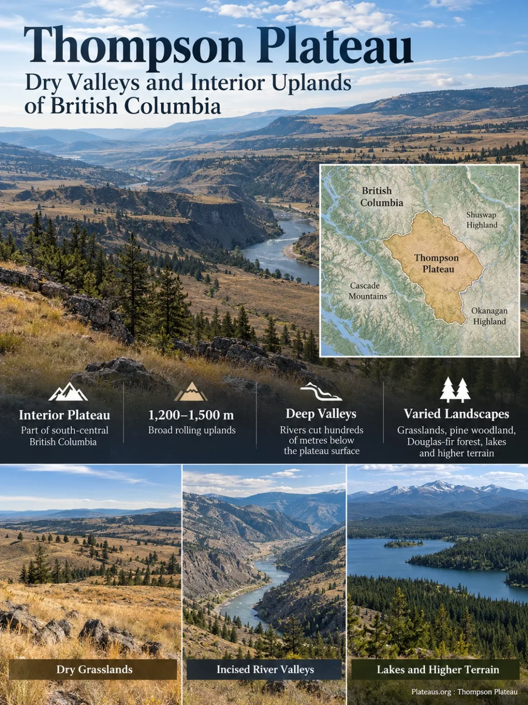
The Thompson Plateau is a broad, deeply dissected upland in the southern Interior of British Columbia. Much of its surface consists of rolling terrain around 1,200–1,500 metres above sea level, yet major rivers cut hundreds of metres below that surface. Dry grasslands, open pine woodland, Douglas-fir forest, lake-dotted uplands and colder high terrain can therefore occur within the same plateau system.
Where the Thompson Plateau Fits in British Columbia
The Thompson Plateau forms part of the Interior Plateau of south-central British Columbia. Its official geographic placement is between the Cascade Mountains and the Shuswap and Okanagan Highlands. Kamloops lies close to its northern side, while Merritt and much of the Nicola country occupy the plateau’s interior.
The eastern side approaches the Okanagan Valley and Okanagan Highland. Farther north and northeast, the terrain grades toward the Shuswap Highland. The southwestern side rises toward the Canadian Cascades, while the Similkameen drainage helps define the strongly dissected southern part of the plateau.
Boundary Note
The Thompson Plateau should not be treated as identical to the Thompson–Okanagan administrative region or the Thompson River watershed. Those areas overlap parts of the plateau but follow different boundaries. The treatment of the Bonaparte Plateau also varies among physiographic descriptions, so its northern limit is not represented identically on every map.
This boundary issue matters because the plateau does not end everywhere at a sharp escarpment. In several directions it grades into neighboring uplands, while major valleys provide much clearer breaks elsewhere.
Why a Deeply Cut Landscape Is Still a Plateau
The word plateau can suggest a flat tabletop, but the Thompson Plateau is better understood as an elevated surface with broadly similar summit levels. Large areas consist of gently rolling uplands rather than flat plains. Resistant hills and mountains rise above that general surface, while rivers and streams have cut deeply into it.
A commonly described elevation range for the main upland surface is roughly 1,220 to 1,520 metres. Local high ground rises well above that level. In contrast, some main valleys lie several hundred metres below the surrounding uplands.
Broad rolling terrain, commonly around 1,200–1,500 m
River erosion cuts far below the older upland surface
Similar summit levels can continue across adjoining high ground
Conceptual cross-section only; elevations and distances are not to scale.
This combination explains an apparent contradiction in the landscape. From the uplands, the terrain can look broad and subdued. From the bottom of a major river valley, the same region can appear steep and mountainous because the valley walls expose the depth of dissection.
The Plateau Surface Records More Than One Geological Episode
The Thompson Plateau is sometimes described too simply as a volcanic plateau. Basalt is part of its geology, but it is not the whole foundation.
Older volcanic and sedimentary rocks form much of the bedrock beneath the region. These rocks belong to the complicated geological history of the Canadian Cordillera and were later cut by large bodies of intrusive rock, including granitic rocks. Younger volcanic activity then placed basaltic lava over parts of the older landscape.
Flows associated with the Chilcotin Group occur in the southern Interior and cover parts of the Thompson Plateau. These lava remnants are not a single uniform slab extending across the entire landform. In some places the volcanic cover is thin or discontinuous; in others, lava occupied older valleys and accumulated more deeply.
Volcanic and Sedimentary Terranes Form the Foundation
Much of the plateau rests on older rock assemblages incorporated into the evolving western margin of North America.
Intrusive Magmas Cut Through the Older Rocks
Granitic and related intrusive bodies became part of the bedrock mosaic now exposed around the plateau and its valleys.
Basaltic Lava Spreads Across Parts of the Upland
Chilcotin Group lava covered sections of older terrain and locally filled pre-existing depressions and valleys.
Ice Reworks the Surface
Repeated glaciation covered the plateau, deposited till and redirected drainage across many upland areas.
Rivers Continue to Cut and Rework Valley Deposits
Modern streams inherited a landscape already shaped by bedrock structure, older valleys, glacial deposits and meltwater drainage.
Pleistocene Ice Reworked Much of the Upland Surface
Glaciation is one of the main reasons the Thompson Plateau has its present surface character. Pleistocene ice covered broad parts of south-central British Columbia and left extensive deposits over the plateau bedrock.
Till forms a widespread surface material in many upland areas. Glaciofluvial sand and gravel record flowing meltwater, while fine glaciolacustrine sediments mark places occupied by ice-dammed or proglacial lakes. River valleys later cut into and reworked many of these deposits.
The effects are visible at several scales. Some areas have streamlined or drumlin-like forms created beneath moving ice. Elsewhere, abandoned meltwater channels run across slopes and uplands that no modern stream could have carved under present drainage conditions.
Glaciers erode bedrock and move large volumes of sediment.
Unsorted glacial sediment remains across broad plateau areas.
Stagnant ice, meltwater channels and temporary lakes alter local drainage routes.
Rivers cut through glacial sediment, form terraces and deepen inherited valleys.
Why Small Lakes Are Scattered Across the Plateau
The numerous small lakes of the Thompson Plateau are closely tied to its glacial history and subdued upland relief. Ice erosion, irregular till deposition and disrupted drainage left many shallow depressions with no efficient outlet. Water collected in these basins after deglaciation.
Some depressions developed into permanent lakes, while others became wetlands, marshes or seasonally wet basins. Local geology, groundwater movement and evaporation determine which depressions retain water.
Lake clusters around places such as Roche Lake demonstrate this lake-dotted upland pattern. Eneas Lakes, farther south, occupy another part of the Thompson Plateau where fir and pine forest surrounds small interior lakes.
The lakes should therefore not be treated as isolated recreational features. Collectively, they are part of the plateau’s glacial geomorphology and hydrology.
River Valleys Expose the Depth of Plateau Dissection
The plateau’s large drainage systems show how far erosion has progressed below the old upland surface. The Thompson, Nicola and Similkameen systems, along with many smaller tributaries, occupy valleys that are much steeper than the rolling country above them.
In parts of the plateau, drainage lies roughly 300 to 600 metres below the general upland level. Local differences can be larger or smaller depending on the valley and surrounding relief.
Bedrock structure also affects valley position. Some streams follow faults or zones of weaker rock, while others occupy routes reorganized by glaciation. Valley floors may contain several generations of sediment: glacial lake silts, outwash gravel, river terraces, alluvial fans and younger floodplain deposits.
Why the Valleys Look So Different
The dry, open appearance of a low valley should not be used as a visual description of the entire Thompson Plateau. A valley floor and a plateau surface may differ sharply in elevation, temperature, moisture, soils and vegetation even when they are only a short horizontal distance apart.
The Nicola Country Shows the Plateau’s Interior Character
The Nicola area around Merritt provides one of the clearest examples of the plateau’s broad interior landscape. Rolling uplands, open grassland, dry forest, lakes and entrenched stream valleys occur within a relatively compact area.
The Nicola Plateau is one of the large physiographic units associated with the Thompson Plateau. Its terrain is mainly rolling upland, while steeper slopes are concentrated along deeply cut drainage lines. Resistant high ground rises above the surrounding surface in places.
Nicola Valley itself sits lower than much of the surrounding plateau. This elevation difference helps produce the familiar transition from open ranching country in lower and drier terrain to more continuous forest on cooler uplands.
The area also shows why the Thompson Plateau cannot be represented by a single elevation, climate station or vegetation type. Topographic position changes environmental conditions rapidly.
Rain Shadow and Elevation Create Strong Ecological Contrasts
The Thompson Plateau lies within the dry southern Interior of British Columbia, but dryness is not distributed evenly. Pacific air loses much of its moisture while crossing mountain barriers to the west. The resulting rain-shadow effect favors dry valleys and lower slopes.
Elevation then modifies that pattern. Air temperatures generally fall with height, snow lasts longer, and moisture stress decreases in many higher areas. As a result, dry grassland can give way to open ponderosa pine, Douglas-fir forest, cooler montane forest and, on sufficiently high ground, subalpine communities.
British Columbia’s biogeoclimatic classification separates these environments into zones based on regional climate, soils and vegetation. Several of those zones occur across the Thompson country.
| Landscape Position | Common Ecological Expression | Characteristic Vegetation | Main Environmental Control |
|---|---|---|---|
| Hot, dry valley bottoms and lower slopes | Bunchgrass and shrub-steppe | Bluebunch wheatgrass, sagebrush, scattered drought-tolerant shrubs | Low precipitation, strong summer moisture deficit and warm conditions |
| Dry lower slopes | Open pine woodland | Ponderosa pine with grasses and open understory | Slightly cooler or moister conditions than open grassland |
| Broad mid-elevation uplands | Interior Douglas-fir forest | Douglas-fir, lodgepole pine, pinegrass and associated shrubs | Moderate elevation with a dry continental climate |
| Cooler upper plateau | Montane forest | Lodgepole pine, hybrid spruce, Douglas-fir and subalpine fir | Lower temperatures, longer snow cover and greater available moisture |
| Highest terrain | Subalpine forest and openings | Engelmann spruce, subalpine fir and high-elevation meadow vegetation | Cold climate and short growing season |
The Sequence Is Not Universal
These vegetation belts do not form a perfectly ordered staircase everywhere. Slope direction, local precipitation, soils, drainage, wildfire history and bedrock can shift zone boundaries or cause one vegetation type to occur beside another.
Grassland Is Concentrated in the Warmest and Driest Terrain
The open grasslands associated with the Thompson country are most developed at lower elevations and on dry slopes. British Columbia’s Bunchgrass zone occurs in some of the hottest and driest Interior valleys, including parts of the Thompson system.
Bluebunch wheatgrass is one of the characteristic native grasses. Big sagebrush becomes common in drier settings, while prickly pear cactus can occur on dry sites. Cooler or slightly moister terrain supports more grass cover, rough fescue communities and eventually open forest.
A useful example occurs in the grasslands north of Kamloops, where ecological conditions change noticeably with elevation. Lower grassland is warmer and drier; middle grassland receives more moisture; upper grassland grades toward Interior Douglas-fir environments. Aspen groves can occupy moist depressions even within otherwise open grassland.
These transitions show why grasslands are not simply treeless versions of the surrounding forest. They occupy particular combinations of temperature, soil moisture, slope exposure, fire history and grazing conditions.
Open Forest and Closed Forest Can Occur on the Same Plateau
Interior Douglas-fir forest covers large parts of British Columbia’s southern Interior and is closely associated with the Thompson Plateau. Its appearance changes strongly with moisture.
On dry sites, Douglas-fir may form widely spaced, park-like stands with a grassy understory. Ponderosa pine can occur at lower elevations, especially on warm slopes. Cooler and wetter uplands support denser Douglas-fir forest, lodgepole pine and, with rising elevation, spruce and subalpine fir.
Wildfire has long influenced this structure. Frequent surface fires historically maintained many open forests and grassland edges by removing young trees and accumulated fuels. Where fire has been absent for long periods, tree establishment can reduce open grassland and create denser forest margins.
Wildlife Distribution Follows the Grassland–Forest–Wetland Mosaic
The plateau supports several distinct habitat types rather than one uniform wildlife community. Dry valleys, open forest, dense uplands, wetlands and lakes each support different groups of species.
Grasslands and Dry Slopes
Mule deer, California bighorn sheep in suitable terrain, grassland birds and several raptors use open environments where visibility and drought-tolerant vegetation dominate.
Forested Uplands
Douglas-fir and lodgepole pine forests provide habitat for animals such as moose, black bear, cougar and many forest birds and small mammals.
Lakes and Wetlands
Shallow lakes, marshes and wet depressions add waterfowl, amphibian and aquatic habitats to an otherwise dry Interior landscape.
Several plateau lakes also contain managed trout fisheries. Stocked fish populations should not be confused with the original ecological condition of every lake, since fish stocking has altered the biological character of many accessible waters.
Ranching Developed From the Geography of the Open Uplands
Cattle ranching became closely associated with parts of the Thompson Plateau because large areas combine open grassland, rolling terrain and dry forest with relatively long grazing seasons at lower elevations.
Ranching is especially visible around the Nicola country and other Interior grasslands. The distribution of rangeland is not random: it follows the same climatic and topographic gradients that produce the grassland and open Douglas-fir ecosystems.
Forestry is more important on wooded uplands, while mining has developed where the varied bedrock contains economically useful mineral deposits. Transportation routes tend to follow major valleys and lower passes rather than crossing the highest uplands directly.
Physiographic Boundaries Do Not Match Cultural Boundaries
The Thompson Plateau overlaps Indigenous cultural landscapes with histories much older than modern physiographic mapping. Nlaka’pamux, Secwépemc and Syilx territories meet or extend across parts of the broader plateau and adjoining valleys.
Those territories should not be forced into the outline of a geological or physiographic unit. Rivers, travel corridors, fishing places, grasslands, uplands and seasonal resource areas have their own cultural geography, while the term Thompson Plateau is a modern landform classification.
The same distinction applies to current administrative regions. The Thompson–Okanagan region includes land beyond the Thompson Plateau, while parts of the wider plateau landscape may be described through other regional or watershed boundaries.
Neighboring Landforms Help Define the Plateau
| Neighboring Area | Relationship | Landscape Contrast |
|---|---|---|
| Cascade Mountains | West and southwest of much of the plateau | Stronger mountain relief and steeper high terrain replace the subdued plateau surface |
| Shuswap Highland | East and northeast | More strongly dissected uplands form a gradual transition in some areas |
| Okanagan Highland | East and southeast beyond the Okanagan Valley system | Higher, more mountainous upland terrain contrasts with broad Thompson Plateau surfaces |
| Okanagan Valley | Major lowland along the eastern side | A deeply developed valley corridor separates high terrain on either side |
| Fraser–Thompson Valley System | Along the western and northern side of the wider plateau landscape | Low, deeply entrenched valleys expose the vertical difference between river level and upland surface |
The transitions are not equally sharp. A deep valley can create an obvious physiographic division, while an upland boundary may be drawn through terrain that changes gradually from one named unit to another.
Fire, Drought and Tree Encroachment Continue to Modify the Landscape
Dryness and wildfire are long-standing parts of the Thompson landscape, particularly in grassland, ponderosa pine and dry Interior Douglas-fir environments. Modern land use, past fire suppression, forest management and a warming climate now interact with those natural controls.
During 2026, prolonged drought remained evident across parts of the Lower and South Thompson and the Okanagan. Those regional conditions do not provide a single drought measurement for the entire Thompson Plateau, but they illustrate the moisture stress affecting many of its warmer valleys and lower uplands.
Another visible process is tree encroachment into grassland. When frequent fire is removed from dry forest–grassland boundaries, young trees can establish in places that previously remained open for longer periods. The result can be shrinking grassland, altered wildlife habitat and larger fuel loads.
Land managers north of Kamloops are using combinations of mechanical thinning and prescribed fire to reopen selected grassland and dry forest areas. The O’Connor Lake project, for example, is planned as a multi-year effort in which prescribed burning is used alongside fuel treatment to reduce tree encroachment, restore grass-dominated habitat and lower wildfire fuel accumulation.
These interventions reflect the same physical geography that shapes the plateau as a whole: low-elevation dryness favors grassland and open forest, higher terrain supports denser woodland, and fire helps maintain the boundary between them. Changes in moisture, fire frequency and forest density can therefore alter the visible structure of the Thompson Plateau even where the underlying landform remains unchanged.